
 Get Email Updates
Now is the time to get involved. Please sign up for project updates via email. (* required)
Information Center
Environmental Assessment
4.0 Affected Environment 
4.1 Introduction
This Section characterizes existing conditions in the NHHS rail corridor and in the study areas defined for purposes of environmental analysis, and discusses future conditions with the No-Build Alternative (i.e., future without the proposed project), and potential impacts that would result with the proposed project and measures to mitigate the impacts. The future analysis year for evaluation of potential impacts is 2030.
Corridor mapping widths of either 1-mile wide or 1000 feet wide were used for resources identified below.
- A corridor approximately 1 mile wide was used for Community Facilities, Median Household Income, Minority Population, Ground Water, and Surface Water.
- A corridor approximately 1000 feet wide was used for Farmland Soils, Hazardous Materials, Cultural Resources, Section 4(f) and 6(f) Resources, Floodplains and Stream Channel Encroachment Lines, Noise and Vibration, Wetlands, Critical Environmental Areas and Threatened and Endangered Species.
A study area of up to 5-mile radius was used around each station for Socioeconomics.
Section 4.0 is organized by environmental category. Each category-specific section discusses the following: summary of impacts and mitigation; applicable law pertinent to the environmental category; methodology used in the analysis; existing conditions in the applicable study area; potential impacts of, first, the No-Build Alternative, followed by potential impacts of the proposed project; and mitigation.
Although portions of the project are in Massachusetts the MassDOT has determined that the work proposed by the NHHS Project in Massachusetts does not trigger any thresholds under MEPA and, therefore, is not subject to review under MEPA. Related correspondence is included in Appendix 8. Future Tier 2 environmental documentation may require review under MEPA.
Detailed documentation of the analyses summarized in this section is found in one of the following locations:
- Volume II of this EA/EIE includes Concept Design Drawings (including a Design Report) and Environmental Resource Graphics;
- The Appendices referenced in the EA/EIA; or
- Various technical reference reports identified in Section 8.0 of this EA/EIE and available upon request.
The following Table 4-1 is a summary of improvements and environmental consequences. The table identifies, which improvements are included in this EA/EIE and which improvements are included in the Phase 1 and Phase 3A CEs. FRA issued environmental decision documents (CEs) for the Phase 1 and 3A improvements but the improvements require additional CEPA review in order to be included in the EIE.
Table 4-1 - Summary of Potential Environmental Consequences & Potential Mitigation
| Environmental Resources | Proposed Improvements | ||||||
|---|---|---|---|---|---|---|---|
| Environmental Assessment/Environmental Impact Evaluation | Phase 1 Categorical Exclusion | Phase 3A Categorical Exclusion | |||||
| Reinstall Track: Mile Posts 7.1 to 17.0, 31.1 to 35.1, 46.7 to 49.0 and 50.4 to 54.8; New Siding: Mile Posts 26.6 to 27.8 | Increased Passenger Train Frequency and Speed (Outcome of Proposed Improvements) | Springfield Layover and Maintenance (See Note 1) | Station Improvements (All stations identified are included in this project except for the future commuter stations printed in bold italics) | Reinstall Track: Mile Posts 20.3 to 31.1 | Reinstall Track and New Siding: Mile Posts 37.2 to 43.0 | ||
| 4.2.1 | Air Quality | No impacts anticipated. | No impacts anticipated. A shift to public transportation should reduce vehicle miles traveled and improve air quality. |
No impacts anticipated. | No impacts anticipated. | No impacts anticipated. | No impacts anticipated. |
| Proposed Mitigation: None | Proposed Mitigation: None | Proposed Mitigation: None | Proposed Mitigation: None | Proposed Mitigation: None | Proposed Mitigation: None | ||
| 4.2.2 | Noise and Vibration | No impacts anticipated. | Severe noise impacts at 1847 receptors; moderate noise impacts at 2767 receptors caused by horn noise at crossings and stations. Moderate wayside noise impacts to 214 receptors and 7 severe receptors. No vibration impacts anticipated. | Low to moderate impact; no mitigation required. | No impacts anticipated. The duration of train horn noise at stations would be very brief and not considered an adverse impact; no mitigation required. |
No impacts anticipated. | No impacts anticipated. |
| Proposed Mitigation: None | Proposed Mitigation: It is proposed that sever horn noise will be mitigated by establishing Quiet Zones. It is proposed the severe wayside noise impacts may be individually mitigated. | Proposed Mitigation: None | Proposed Mitigation: None | Proposed Mitigation: None | Proposed Mitigation: None | ||
| 4.2.3 | Topography and Geology | No impacts anticipated. | No impacts anticipated. | No impacts anticipated. | No impacts anticipated. | No impacts anticipated. | No impacts anticipated. |
| Proposed Mitigation: None | Proposed Mitigation: None | Proposed Mitigation: None | Proposed Mitigation: None | Proposed Mitigation: None | Proposed Mitigation: None | ||
| 4.2.4 | Floodplains and Stream Channel Encroachment Lines | Anticipated impacts of up to 0.5 acres floodway, 3.4 acres floodplains, and 2.0 acres SCEL from double-tracking and rail siding. Additional impacts from bridges and culverts. | No impacts anticipated. | No impacts anticipated. | Up to 3.4 acres of floodplain impacts from North Haven, Meriden, Newington, Windsor, and Windsor Locks (South Main St) stations (combined). | See Note 2. Impacts to up to 2.1 acres of 100-year floodplains, 0.5acres of floodway, and 0.1 acres of SCELs. Will be reduced by minimizing expansion of the trackbed. | Up to 1.8 acres of impact to 100-year floodplains. No other impacts. Will be reduced by minimizing expansion of the trackbed. |
| Proposed Mitigation: It is proposed that mitigation to be provided through coordination with CTDEEP and compliance with all federal requirements. | Proposed Mitigation: None | Proposed Mitigation: None | Proposed Mitigation: It is proposed that mitigation to be provided through coordination with CTDEEP and compliance with all federal requirements. | Proposed Mitigation: It is proposed that mitigation to be provided through coordination with CTDEEP and compliance with all federal requirements. | Proposed Mitigation: It is proposed that mitigation to be provided through coordination with CTDEEP and compliance with all federal requirements. | ||
| 4.3.1 | Critical Environmental Areas and Threatened and Endangered Species | 16 to 18 listed species and/or their habitats occur in CT in vicinity of double-track areas. USFWS has identified the dwarf wedge mussel has been known to occur within the Farmington River (MP44). | No impacts anticipated. | No impacts anticipated. | Between 2 and 15 listed species and/or their habitats occur in CT in vicinity of New Haven, North Haven, Wallingford, Windsor, Windsor Locks, and Enfield stations. | One potential sensitive/critical habitat at MP23. | 16 listed species and/or their habitats occur in CT at MP43 and in the Windsor area. |
| Proposed Mitigation: Work will be within existing RR ROW, minimizing potential risk to this habitat. Coordinate with USFWS if work occurs in Farmington River at MP 44. | Proposed Mitigation: None | Proposed Mitigation: None | Proposed Mitigation: Impacts will be avoided and/or mitigated through further design and coordination with CTDEEP. | Proposed Mitigation: Risk would be avoided by remaining within existing RR ROW. | Proposed Mitigation: Risk would be avoided by remaining within existing RR ROW. | ||
| 4.3.2 | Water Resources and Water Quality | No impacts anticipated to ground water, some potential impacts to surface water. | No impacts anticipated. | No impacts anticipated. | No impacts anticipated to ground water, some potential impacts to surface water. | No impacts anticipated. | No impacts anticipated. |
| Proposed Mitigation: Coordinate with CTDEEP and FRA, including appropriate mitigation and comply with all federal and state requirements. | Proposed Mitigation: None | Proposed Mitigation: None | Proposed Mitigation: Coordinate with CTDEEP and FRA, including appropriate mitigation and comply with all federal and state requirements. | Proposed Mitigation: None | Proposed Mitigation: None | ||
| 4.3.3 | Wetlands | Up to 1.3 acres of potential impact from double-tracking and rail siding. Additional impacts from bridges and culverts. | No impacts anticipated. | No impacts anticipated. | No impacts anticipated. | See Note 2. Up to 1.6 acres of potential impact. | Up to 1.0 acre of potential impact. |
| Potential Mitigation: Impacts to be reduced by minimizing expansion of ROW and mitigated through CTDEEP and USACE permitting process and appropriate compensatory mitigation. | Proposed Mitigation: None | Proposed Mitigation: None | Proposed Mitigation: None | Potential Mitigation: Impacts to be reduced by minimizing expansion of ROW and mitigated through CTDEEP and USACE permitting process and appropriate compensatory mitigation. | Potential Mitigation: Impacts to be reduced by minimizing expansion of ROW and mitigated through CTDEEP and USACE permitting process and appropriate compensatory mitigation. | ||
| 4.3.4 | Wild and Scenic Rivers, Navigable Waterways, and Coastal Resources | No impacts anticipated to the Connecticut River in Windsor Locks. | No impacts anticipated. | No impacts anticipated. | No impacts anticipated; however, Coastal Area Management review required for North Haven Station. | No impacts anticipated. | No impacts anticipated. |
| Proposed Mitigation: None | Proposed Mitigation: None | Proposed Mitigation: None | Proposed Mitigation: None | Proposed Mitigation: None | Proposed Mitigation: None | ||
| 4.3.5 | Prime Farmlands and Farmlands of Statewide Importance | Potentially a total of 4.0 acres of impact along the 62 mile corridor | No impacts anticipated. | No impacts anticipated. | No impacts anticipated. | No impacts anticipated. | No impacts anticipated. |
| Proposed Mitigation: Mitigation through application of the Farmland Conversion Impact Rating Form, and compensatory mitigation. | Proposed Mitigation: None | Proposed Mitigation: None | Proposed Mitigation: None | Proposed Mitigation: None | Proposed Mitigation: None | ||
| 4.4.1 | Land Use and Zoning | No impacts anticipated. | No impacts anticipated. | No impacts anticipated. | Proposed use is consistent with local zoning. Both beneficial and adverse impacts for 6 station locations. No other anticipated land use impacts. | No impacts anticipated. | No impacts anticipated. |
| Proposed Mitigation: None | Proposed Mitigation: None | Proposed Mitigation: None | Proposed Mitigation: Will maintain ongoing coordination with affected communities during final design. | Proposed Mitigation: None | Proposed Mitigation: None | ||
| 4.4.2 | Consistency with State, Regional and Local Plans | No impacts anticipated. | No impacts anticipated. | No impacts anticipated. | The Towns of Wallingford and Windsor Locks have not selected between two station locations options. | No impacts anticipated. | No impacts anticipated. |
| Proposed Mitigation: None | Proposed Mitigation: None | Proposed Mitigation: None | Proposed Mitigation: Continue to consult with Towns of Wallingford and Windsor Locks to reach consensus. | Proposed Mitigation: None | Proposed Mitigation: None | ||
| 4.4.3 | Property Acquisitions and Displacements | No impacts anticipated. | No impacts anticipated. | 2 full and 2 partial property acquisitions, which would be consistent with local development plans. | 16 full and 11 partial property acquisitions, which would be consistent with local development plans. | See Note 3. | Possible requirement for small takings, which will be mitigated by minimizing expansion of ROW. |
| Proposed Mitigation: None | Proposed Mitigation: None | Proposed Mitigation: Uniform Relocation Act will apply to any property acquisition or taking. | Proposed Mitigation: Uniform Relocation Act will apply to any property acquisition or taking. | Proposed Mitigation: Uniform Relocation Act will apply to any property acquisition or taking. | Proposed Mitigation: Uniform Relocation Act will apply to any property acquisition or taking. | ||
| 4.4.4 | Socio-economics | No impacts anticipated. | Project related impacts on socioeconomic conditions would be beneficial. | No impacts anticipated. | No impacts anticipated. | No impacts anticipated. | No impacts anticipated. |
| Proposed Mitigation: None | Proposed Mitigation: None | Proposed Mitigation: None | Proposed Mitigation: None | Proposed Mitigation: None | Proposed Mitigation: None | ||
| 4.4.5 | Community Resources and Neighborhood Character | No impacts anticipated. | Minimal impact due to noise and traffic congestion at grade crossings. Project related impacts on community resources and neighborhood character would be beneficial. | No impacts anticipated. | No impacts anticipated. | No impacts anticipated. | No impacts anticipated. |
| Proposed Mitigation: None | Proposed Mitigation: Horn noise will be mitigated by establishing Quiet Zones. Traffic congestion at grade crossings will be mitigated with traffic signal and intersection improvements. | Proposed Mitigation: None | Proposed Mitigation: None | Proposed Mitigation: None | Proposed Mitigation: None | ||
| 4.4.6 | Visual Resources and Quality | No impacts anticipated. | No impacts anticipated. | No impacts anticipated. | Potential adverse impacts at Berlin, Windsor Locks (North Main Street), Wallingford (Rt 5), Newington, Windsor and Enfield stations. No impacts anticipated at other station locations. | No impacts anticipated. | No impacts anticipated. |
| Proposed Mitigation: None | Proposed Mitigation: None | Proposed Mitigation: None | Proposed Mitigation: Impacts to be minimized and mitigated through ongoing community coordination and design reviews. | Proposed Mitigation: None | Proposed Mitigation: None | ||
| 4.4.7 | Cultural Resources | Impacts will be as stipulated in Programmatic Agreement | Impacts will be as stipulated in Programmatic Agreement | Impacts will be as stipulated in Programmatic Agreement | Impacts will be as stipulated in Programmatic Agreement | Impacts will be as stipulated in Programmatic Agreement | Impacts will be as stipulated in Programmatic Agreement |
| Proposed Mitigation: Mitigation will be as stipulated in Programmatic Agreement | Proposed Mitigation: Mitigation will be as stipulated in Programmatic Agreement | Proposed Mitigation: Mitigation will be as stipulated in Programmatic Agreement | Proposed Mitigation: Mitigation will be as stipulated in Programmatic Agreement | Proposed Mitigation: Mitigation will be as stipulated in Programmatic Agreement | Proposed Mitigation: Mitigation will be as stipulated in Programmatic Agreement | ||
| 4.4.8 | Section 4(f) | Impacts will be as stipulated in Programmatic Agreement | Impacts will be as stipulated in Programmatic Agreement | Impacts will be as stipulated in Programmatic Agreement | Impacts will be as stipulated in Programmatic Agreement | Impacts to historical bridges and culverts resulting from repairs/replacement. | Impacts to historical bridges and culverts resulting from repairs/replacement. |
| Proposed Mitigation: Mitigation will be as stipulated in Programmatic Agreement | Proposed Mitigation: Mitigation will be as stipulated in Programmatic Agreement | Proposed Mitigation: Mitigation will be as stipulated in Programmatic Agreement | Proposed Mitigation: Mitigation will be as stipulated in Programmatic Agreement | Proposed Mitigation: Mitigation through consultation and compliance with requirements of the SHPO and FRA and USACE permitting. | Proposed Mitigation: Mitigation through consultation and compliance with requirements of the SHPO and FRA and USACE permitting. | ||
| 4.4.9 | Section 6(f) Resources | No impacts anticipated. | No impacts anticipated. | No impacts anticipated. | No impacts anticipated. | No impacts anticipated. | No impacts anticipated. |
| Proposed Mitigation: None | Proposed Mitigation: None | Proposed Mitigation: None | Proposed Mitigation: None | Proposed Mitigation: None | Proposed Mitigation: None | ||
| 4.4.10 | Parkland Resources | No impacts anticipated. | No impacts anticipated. | No impacts anticipated. | No impacts anticipated. | No impacts anticipated. | No impacts anticipated. |
| Proposed Mitigation: None | Proposed Mitigation: None | Proposed Mitigation: None | Proposed Mitigation: None | Proposed Mitigation: None | Proposed Mitigation: None | ||
| 4.4.11 | Transportation | No impacts anticipated. | Project related impacts on transportation options available would be beneficial. Increased traffic congestion at 9 grade crossings. | No impacts anticipated. | Increased traffic congestion at 2 intersections. | No impacts anticipated. | No impacts anticipated. |
| Proposed Mitigation: None | Proposed Mitigation: Traffic congestion at grade crossings will be mitigated with traffic signal and intersection improvements. | Proposed Mitigation: None | Proposed Mitigation: Traffic congestion at intersections will be mitigated with traffic signal and intersection improvements | Proposed Mitigation: None | Proposed Mitigation: None | ||
| 4.4.12 | Public Utilities and Energy Requirements | No impacts anticipated. | No impacts anticipated. Project related impacts on energy would be beneficial. |
No impacts anticipated. | May require some utility relocation. | No impacts anticipated. | No impacts anticipated. |
| Proposed Mitigation: None | Proposed Mitigation: None | Proposed Mitigation: None | Proposed Mitigation: Coordinate with utilities to eliminate or minimize disruption. | Proposed Mitigation: None | Proposed Mitigation: None | ||
| 4.4.13 | Hazardous Materials | Waste and toxic materials typical of railroad rights-of-way. | No impacts anticipated. | Waste and toxic materials typical of railroad ROW. | Buildings requiring demolition can contain lead and asbestos. Potential hazardous waste at North Haven property to be acquired. | Waste and toxic materials typical of railroad ROW. | Waste and toxic materials typical of railroad ROW. |
| Proposed Mitigation: Investigation during final design. Develop and comply with Waste Management Plan. | Proposed Mitigation: None | Proposed Mitigation: Investigation during final design. Develop and comply with Waste Management Plan. | Proposed Mitigation: Investigation during final design. Develop and comply with Waste Management Plan. | Proposed Mitigation: Investigation during final design. Develop and comply with Waste Management Plan. | Proposed Mitigation: Investigation during final design. Develop and comply with Waste Management Plan. | ||
| 4.4.14 | Safety and Security | No impacts anticipated. | Increased Passenger Train Frequency and Speed | No impacts anticipated. | No impacts anticipated. | No impacts anticipated. | No impacts anticipated. |
| Proposed Mitigation: None | Proposed Mitigation: Grade crossings will be improved with supplemental safety devices. | Proposed Mitigation: None | Proposed Mitigation: None | Proposed Mitigation: None | Proposed Mitigation: None | ||
| 4.4.15 | Environmental Justice | No impacts anticipated. | Beneficial impact of new or improved access to regional rail service. Adverse impact from increased traffic congestion at several grade crossings. | No impacts anticipated. | Provide stations near to EJ Populations improving mobility options. Impact due to increased traffic congestion at several intersections. | No impacts anticipated. | No impacts anticipated. |
| Proposed Mitigation: None | Proposed Mitigation: Traffic congestion at grade crossings will be mitigated with traffic signal and intersection improvements. | Proposed Mitigation: None | Proposed Mitigation: Traffic congestion at intersections will be mitigated with traffic signal and intersection improvements | Proposed Mitigation: None | Proposed Mitigation: None | ||
| 4.4.16 | Secondary and Cumulative Impacts | No impacts anticipated. | Secondary impacts are generally beneficial due to induced development. | No impacts anticipated. | Secondary impacts are generally beneficial due to induced development. Potential for traffic congestion impacts at intersections as station development increases. | No impacts anticipated. | No impacts anticipated. |
| Proposed Mitigation: None | Proposed Mitigation: None | Proposed Mitigation: None | Proposed Mitigation: Traffic congestion at intersections will be mitigated with traffic signal and intersection improvements | Proposed Mitigation: None | Proposed Mitigation: None | ||
| 4.4.17 | Construction Impacts | Impacts will be temporary, including train speed restrictions, noise, air quality, water quality, disposal of construction waste, contaminated soils, and utility impacts. | No impacts anticipated. | Impacts will be temporary, including train speed restrictions, noise, air quality, water quality, disposal of construction waste, contaminated soils, and utility impacts. | Impacts will be temporary, including lane restrictions, train speed restrictions, noise, air quality, water quality, disposal of construction waste, contaminated soils, and utility impacts. | Impacts will be temporary, including train speed restrictions, noise, air quality, water quality, disposal of construction waste, contaminated soils, and utility impacts. | Impacts will be temporary, including train speed restrictions, noise, air quality, water quality, disposal of construction waste, contaminated soils, and utility impacts. |
| Proposed Mitigation: Mitigation incorporating Best Management Practices, maintenance of traffic, and compliance with permits. | Proposed Mitigation: None | Proposed Mitigation: Mitigation incorporating Best Management Practices, maintenance of traffic, and compliance with permits. | Proposed Mitigation: Mitigation incorporating Best Management Practices, maintenance of traffic, and compliance with permits. | Proposed Mitigation: Mitigation incorporating Best Management Practices, maintenance of traffic, and compliance with permits. | Proposed Mitigation: Mitigation incorporating Best Management Practices, maintenance of traffic, and compliance with permits. | ||
| 4.4.18 | Irreversible and Irretrievable Commitment of Resources | No impacts anticipated. | No impacts anticipated. | No impacts anticipated. | No impacts anticipated. | No impacts anticipated. | No impacts anticipated. |
| Proposed Mitigation: None | Proposed Mitigation: None | Proposed Mitigation: None | Proposed Mitigation: None | Proposed Mitigation: None | Proposed Mitigation: None | ||
| Note 1. The impacts for the Springfield Layover are based on using the Armory site. If the Springfield station or the Sweeny Yard are used, there would be no impacts anticipated. Note 2. Based on the information available during the preparation of the CE and knowing that the corridor historically carried two tracks, it was expected that the new track could be installed without permanent wetland or flood plain impacts; wetland impacts would be temporary during bridge and culvert work. During PE, with the topographical/ROW survey completed and design criteria established for track centers and shoulders, it is now recognized that permanent impacts would occur to avoid new retaining walls. However, Amtrak has indicated that it will work with CTDOT to avoid any such adverse impacts. Note 3. Based on the information available during the preparation of the CE and knowing that the corridor had historically carried two tracks, it was expected that the new track could be installed without ROW takes. During PE, with the topographical/ROW survey completed and track center design criteria established, it has been recognized that sliver takes may be required. Any necessary property takes would comply with federal requirements. |
|||||||
4.2 Physical Environment
The study area for the New Haven-Hartford-Springfield Line High Speed Intercity Passenger and Regional Rail Service Project has been generally established as a 1000-foot-wide corridor encompassing the rail line its full length from New Haven to Springfield. This study area was broadened to 1 mile or more from the rail line for the consideration of some social and community resources such as neighborhoods. For example, an even wider study area was included for the air quality and socio-economic analyses to take into consideration the logical extent (i.e. an entire cohesive neighborhood) of existing conditions important to the resource being evaluated.
Evaluation of the potential environmental impacts from restoration of the second track between Meriden and Newington (MP 20.3 to 31.1) and between Hartford and Windsor (MP 37.2 to 43.0) was completed in separate environmental documents (CEs for Phase 1 and Phase 3A). This EA/EIE includes information on existing conditions relative to those segments on the maps and identifies potential project impacts. The impacts and identified mitigation for the proposed project are also summarized in Table 4-1.
4.2.1 Air Quality
Summary
The proposed project would not result in any local or regional short-term or long-term adverse air quality impact. As the proposed project complies with current control measures and is consistent with emissions budgets, it is determined to be in conformity with the Clean Air Act, as amended, pursuant to all applicable U.S. Environmental Protection Agency (EPA) regulations.
Details of the applicable law, methodologies, air quality analyses and findings are provided in the Air Quality Results Technical Report. See Section 8 for technical report availability.
Applicable Law
The EPA established National Ambient Air Quality Standards (NAAQS) for six commonly found air pollutants (criteria pollutants) in the Clean Air Act and 1990 Clean Air Act Amendments (CAAA). These pollutants are carbon monoxide (CO), ozone, particulate matter (PM), nitrogen dioxide (NO2), sulfur dioxide (SO2) and lead. The CAA defines nonattainment areas as geographic regions that have been designated as not meeting one or more of the NAAQS; it requires that a State Implementation Plan (SIP) be prepared for each non-attainment area and a maintenance plan be prepared for each former non-attainment area that subsequently demonstrated compliance with the standards. EPA's Conformity Rule (40 CFR 93) requires SIP conformity determinations on transportation plans, programs and projects before they are approved or adopted. Conformity is defined as conformity to a SIP's purpose of eliminating or reducing the severity and number of violations of the NAAQS and achieving expeditious attainment of the standards. The Conformity Rule also establishes the process by which federal agencies determine conformance of proposed projects; federal activities may not cause or contribute to new violations of air quality standards, exacerbate existing violations or interfere with timely attainment or required interim emissions reductions toward attainment.
Methodology
As FRA is the lead agency, a General Conformity analysis was conducted. Because the proposed project is also an FTA project a Transportation Conformity analysis was also completed.
The air quality analysis was conducted in June 2011 with data from and in accordance with the procedures outlined in EPA guidance documents including Transportation Conformity Guidance for Qualitative Hot-spot Analyses in PM2.5 and PM10 Nonattainment and Maintenance Areas (March 2006) and the EPA Region 1 2009 Annual Report on Air Quality in New England (October 2010) report.
Local impact analysis is conducted at the project level and focuses on potential project-related carbon monoxide (CO) impacts on local air quality. A modeling analysis was conducted to calculate CO concentrations at sensitive receptor locations near intersections most likely to be impacted by the proposed project; concentrations were calculated for existing conditions, the No-Build Alternative, and the proposed project without and with mitigation. The modeling analysis determined whether changes in vehicular traffic conditions on local roadways would create violations of federal CO standards. The analysis was conducted using the EPA MOBILE6.2 emissions factor model and the CALQVIEW2 (Windows version of CAL3QHC Version 2) model.
Existing Conditions
The NHHS rail corridor is located in New Haven and Hartford counties in Connecticut and Hampden County in Massachusetts. The most current available data for air quality monitoring locations, exceedances, and attainment designations for the six criteria pollutants in New Haven, Hartford, and Hampden counties are displayed in Table 4-2. Connecticut ceased monitoring lead in 2002 because of extremely low ambient levels. Massachusetts does not have a lead monitoring site in the project area.
Table 4-2 - Project Area Air Quality Status
| Pollutant | Number of Monitors | Monitor Locations | Exceedance | Attainment Status |
|---|---|---|---|---|
| CO | 4 | 1 James Street, New Haven McAuliffee Park, East Hartford 155 Morgan Street, Hartford Liberty Street, Springfield |
None | Attainment |
| Ozone | 4 | 1 James Street, New Haven Hammonasset State Park, Madison McAuliffee Park, East Hartford Anderson Road AFB, Chicopee |
At all monitors | Nonattainment in all areas of CT and MA |
| PM10 | 4 | 1 James Street, New Haven Meadow and Bank Street, Waterbury McAuliffee Park, East Hartford 1860 Main Street, Springfield |
None | Attainment |
| PM2.5 | 10 | 1 James Street, New Haven Woodward Avenue, New Haven 715 State Street, New Haven Huntington Street, New Haven Meadow and Bank Street, Waterbury McAuliffee Park, East Hartford 85 High Street, East Hartford 1860 Main Street, Springfield Liberty Street, Springfield Anderson Road AFB, Chicopee |
At New Haven County Monitors. | Nonattainment in New Haven County. Attainment in all other areas. |
| NO2 | 4 | 1 James Street, New Haven McAuliffee Park, East Hartford Liberty Street, Springfield Anderson Road AFB, Chicopee |
None | Attainment |
| SO2 | 3 | 1 James Street, New Haven 85 High Street, East Hartford Liberty Street, Springfield |
None | Attainment |
Source: EPA Region 1, 2009 Annual Report on Air Quality in New England, October 2010.
For transportation projects, the criteria pollutants of greatest concern are CO and ozone as they are predominantly influenced by motor vehicle activity. PM2.5 (particulate matter smaller than or equal to 2.5 microns in size) is also a key pollutant because of the relative proximity of the study corridor to the New York Metropolitan Area, which is in nonattainment. In the past 9 years, overall trends in annual concentration of PM2.5 show a downward trend (with the exception of a slight increase in 2005).
Impacts
No-Build Alternative
The No-Build Alternative would constitute a continuance of existing rail operations to existing rail stations. With no new track, no station improvements or relocations and no new stations, the No-Build Alternative would not result in change to air quality conditions.
Proposed Project
General Conformity Determination: In the Connecticut Statewide Transportation Improvement Program (STIP), there are FRA funds for project # 170-2296, New Haven - Springfield Corridor Second Track. Because this project is listed in the STIP, it has been included in the statewide model, which, when run, did not exceed the budgets allowed for in the SIP. On that basis, the proposed project demonstrates General Conformity.
Transportation Conformity Determination: The proposed project is included in the current Regional Transportation Plans (RTP) of the four Metropolitan Planning Organizations1 (MPO) but is not included in their Transportation Improvement Programs (TIP). The proposed project must meet the following criteria for determining conformity of a project that is not from a conforming RTP and TIP:
- Transportation Control Measures (TCMs) - As there are no TCMs in the current SIP, the proposed project does not interfere with their implementation.
- Currently Conforming Regional Transportation Plan and TIP - In Connecticut, the MPOs' current 2007 Long-Range Transportation Plan (LRTP) and the 2010-2013 Statewide Transportation Improvement Program (STIP), which incorporates the MPOs' current TIPs, were determined to be in conformity by FHWA and FTA on November 13, 2009. In Massachusetts, the 2007 Update to the RTP for the Pioneer Valley MPO and the 2011-2014 TIP were both found to conform to the SIP.
- CO, PM10 and PM2.5 Hot Spots - The proposed project would not cause or contribute to any new localized CO, PM2.5 and/or particulate matter between 2.5 and 10 microns in diameter (PM10) violations or increase the frequency or severity of any existing CO, PM10 and/or PM2.5 violations in CO, PM10and/or PM2.5nonattainment and maintenance areas. None of the improvements with the proposed project would cause or contribute to any new violations or increase the frequency or severity of any existing CO violations in CO nonattainment or maintenance areas.
The proposed project is partially located in a PM2.5 nonattainment area. The proposed project could potentially be a project of local air quality concern because of the potential increase of diesel vehicles along the rail line. Beginning in December 2012, a quantitative PM2.5 hot spot analysis will be required; at that time, the EPA MOVES model will be required as the industry standard. Future Tier 2 environmental documentation involving FTA would require this analysis. The new MOVES model will be a more stringent analysis (incorporating more variables) than the model in use today. Consequently, based on application of the new, more stringent analysis, the potential for PM2.5 hot spots along the study corridor from the increased rail activity with the proposed project could theoretically be higher than that with the No-Build Alternative. However, the most likely scenario is that emissions and hot spots would be less likely along the study corridor in the future because of the overall significant reductions in emissions projected by EPA for the study corridor and the region.
- PM10 and PM2.5 Control Measures - The proposed project must comply with PM10 and PM2.5control measures in the SIP. There are no PM10 or PM2.5 control measures in the current SIPs, so this criterion is met.
- Emissions Budget or Emissions Reduction - The proposed project has been demonstrated to be consistent with the motor vehicle emissions budgets in the SIPs as evidenced by Connecticut's Ozone Air Quality Conformity Determination, dated February 2006, and Massachusetts' Ozone Conformity Determination, dated June 2005.
In summary, because the proposed project complies with current control measures and is consistent with emissions budgets, it is determined to be in conformity with the Clean Air Act, as amended, pursuant to all applicable EPA regulations.
Local Impacts: To assess potential project-related CO impacts on local air quality, a modeling analysis was conducted in August 2011 to calculate CO concentrations in existing conditions (2011), with the No-Build Alternative and with the proposed project in the opening year of operation (2016) and the design year (2030). Concentrations were calculated at sensitive receptor locations near intersections most likely to be affected by the proposed project. The modeling analysis determined that the proposed project would not create violations of federal CO standards.
Capacity and queuing analyses were performed for the three highest volume intersections and three signalized intersections having the worst levels of service (LOS) in the study corridor (Table 4-3). Four intersections were analyzed because both the Chapel Street/State Street and the Asylum Avenue/Spruce Street intersections show the highest volumes and worst LOS.
Table 4-3 - Highest Volume and Worst LOS Intersections
Source: CTDOT, June, 2011
The highest CO reading for each of 42 model runs are presented in Table 4-4.
Table 4-4 - Highest Predicted CO Results by Analysis Period and Year and Receptor Location
Source: CALQView2 Model Runs, August 2011.
Note: NAAQS for CO: 1-hour standard of 35.0 ppm, 8-hour standard of 9.0 ppm.
PPM - parts per million
The highest future CO concentration would occur at the Asylum Avenue/Spruce Street intersection in the 2011 existing PM condition, with a 1-hour CO concentration of 7.5 parts per million (ppm) and an 8-hour CO concentration of 5.3 ppm. The results show that no violations of federal CO standards are expected near the regional rail stations forecast to have the highest traffic volumes and worst LOS with the proposed project. As the four intersections analyzed would have the worst impacts with the proposed project but would not result in a violation of the federal CO standards, there is little concern regarding air quality impacts at all other signalized intersections near the stations.
These findings appear to be reasonable, based on the following:
- Air quality monitoring data show that existing CO levels in the overall region and states are well below the CO NAAQS. Therefore, CO hot spots would be highly unlikely in the vicinity of the proposed project.
- The low level of auto trips generated by the proposed project relative to total regional trips is unlikely to negatively impact regional air quality. The VOC, NOx and CO emissions from the transportation system are currently below those allowed in the SIP. Thus, the effects of increased travel near the stations can be accommodated without causing the emission budgets to be violated and, therefore, would not cause or contribute to further violations of the NAAQS. Furthermore, recent monitored ozone exceedances are primarily due to the transport of ozone and other pollutants from beyond Connecticut. The low number of additional vehicle trips is unlikely to cause or contribute to further ozone exceedances.
Mitigation
No short-term or long-term adverse air quality impacts are anticipated as a result of the proposed project, therefore air quality mitigation measures are not proposed.
4.2.2 Noise and Vibration
Summary
Noise: Train-horn noise at grade crossings and existing and new regional rail stations would result in potential severe noise impacts at 1,804 Category 2 noise-sensitive receptors where nighttime quiet is important and 43 Category 3 receptors with daytime noise-sensitive activities. Moderate train-horn noise impacts would occur at 2,730 Category 2 nighttime noise-sensitive receptors and 37 Category 3 daytime noise-sensitive receptors. Wallingford, Meriden, and Windsor would have the most train-horn noise impacts, as each has multiple grade crossings amid residences, parks, churches, schools and other noise-sensitive receptors. However, designation of Quiet Zones, which eliminates horn-noise impacts at public crossings, would be used to mitigate severe train-horn noise impacts. As part of the proposed project, Amtrak will add supplemental safety devices at all public crossings along the NHHS rail corridor, as necessary, to meet Quiet Zone requirements and to provide additional safety protection to prevent motorists from attempting to drive around the gates. This would enable the affected municipalities and Amtrak to jointly apply to FRA, which would make a determination on the appropriateness of the Quiet Zone designations. Other options for horn noise mitigation include wayside horns, barriers, or insulation.
Seven noise-sensitive residential receptors that abut the rail corridor in the Town of Berlin would experience severe impact from project-related wayside train noise. As the residences are not clustered, increased noise insulation and/or other home-specific improvements could be considered as mitigation to reduce the potential severity of indoor noise impacts. Project-related wayside train noise may also result in moderate impact to 214 residential receptors, predominantly in the towns of Berlin, Enfield, Wallingford, Newington, and Windsor. Each receptor, both severely and moderately impacted would be evaluated on a case-by-case basis during the proposed project's final design phase to ascertain the need for mitigation, the level of noise reduction that could be achieved and the most cost-effective solution and could include insulation or barriers.
Vibration: No vibration sensitive receptors are located near the tracks, however, CTDOT will evaluate potential vibration-sensitive receptors on a case-by-case basis and determine the impact and the need for mitigation, based on the proposed project's track configuration determined during the final design phase or project development.
The following is organized as two sub-sections, addressing noise- and vibration-related analyses and findings, respectively.
Applicable Law
NEPA requires Federal agencies to consider the noise and vibration impacts of Federal actions. Federal guidance is provided for noise and vibration evaluation for rail projects, as described below. There are no additional governing State of Connecticut statutes applicable to noise and vibration.
Noise
Methodology
Federal guidance manuals and models used to assess potential noise impacts are as follows:
- The general noise assessment procedures in Section 4 of FRA's High-Speed Ground Transportation Noise and Vibration Impact Assessment manual (October 2005) were used to evaluate potential wayside train noise impacts in the study corridor;
- FRA's Horn Noise Model was used to assess impacts to noise-sensitive receptors near at-grade crossings and stations; and
- FTA's Transit Noise and Vibration Impact Assessment manual (FTA-VA-90-1003-06; May, 2006) was used to assess potential noise (and vibration) impacts on sensitive receptors from the proposed train layover/maintenance facility and station parking.
The analysis methodology and findings summarized in this section are detailed in the Noise Technical Memorandum. Data inputs for the analyses were obtained and/or developed for each town in the NHHS rail corridor, and existing train schedules, speeds and other relevant data were gathered from the preliminarily defined Passenger Service Plan.
Because the predominant source of noise from implementation of the project would result from the increased sounding of train horns, CTDOT used the FRA Horn Noise model to conduct the noise impact assessment. The model uses a spreadsheet train horn noise model to predict noise levels to the side of the railway and anticipated effects using FRA noise impact criteria. See http://www.fra.dot.gov/Pages/254.shtml . As inputs into the model, existing noise levels were estimated at noise-sensitive receptors based on identification of the major noise source, typically the existing rail line, affecting each receptor. However, in portions of West Hartford, Hartford, North Haven, and Windsor Locks, the major noise source is a highway (I-84 or I-91) rather than rail due to the proximity of highways to some of the noise-sensitive receptors in the study corridor. The existing noise levels calculated by the FRA model were successfully validated using ambient noise measurements taken by CTDOT in 2009 at five noise-sensitive receptors in the study corridor.
Characteristics of Noise: Noise is generally defined as unwanted sound. Human response to sound depends on the magnitude of a sound (how loud) as a function of its frequency (pitch) and duration. Because the range of magnitude, from the faintest to the loudest sound the human ear can detect is very large, sound is expressed on a logarithmic scale in units called decibels (dB). Loudness refers to how a person subjectively judges a sound, which varies from person to person.
Environmental noise comprises many frequencies with each sound occurring simultaneously. The commonly used frequency weighting for environmental noise is the A-weighted decibel (dBA), which is most similar to how humans perceive sounds of low to moderate magnitude. Typical A-weighted sound levels associated with both transit and non-transit sources are presented in Figure 4-1. Because of the logarithmic decibel scale, a doubling of the number of identical noise sources increases noise levels by only 3 dBA. Thus, two noise sources, each emitting a noise level of 50 dBA, yield a combined noise level of 53 dBA. A tenfold increase in the number of identical noise sources adds 10 dBA to the overall noise level. Thus, ten similar sources, each emitting a noise level of 50 dBA, yield a combined noise level of 60 dBA. Studies have shown that a 3 dBA increase in noise is barely perceptible to the human ear, whereas a change of 5 dBA is readily perceptible; as a general rule, an increase or decrease of 10 dBA in noise level is perceived by a person to be a doubling or halving of the sound, respectively.
Figure 4-1 - Typical A-weighted Sound Levels for Transit and Non-transit Sources
Source: Federal Transit Administration (FTA) Transit Noise and Vibration Impact Assessment (FTA-VA-90-1003-06; May, 2006).
Noise Level Descriptors: The preferred descriptor for environmental noise assessments is the day-night sound level (Ldn). Ldn provides an accurate measure of the overall "noise climate "of an area. Rather than representing the moment-to-moment variation in sound levels, Ldn describes the cumulative effect of all noise sources over a longer period of time. Typical Ldn levels in various areas are shown in Figure 4-2.
Figure 4-2 - Comparison of Various Noise Levels
Source: Federal Railroad Administration, 2011: http://www.fra.dot.gov/Pages/1173.shtml
Wayside Train Noise Analysis Methodology:Because noise is a function of distance, train-related noise level was first estimated at 50 feet from the centerline of the tracks, and then at successively greater (and lesser) distances until a noise-versus-distance curve was derived. Then, the distance at which project-related noise exposure would result in a moderate or severe impact was derived based on noise impact criteria established by FTA/FRA. Moderate and severe noise-impact contours, which vary in width by municipality due to existing ambient noise levels and train speeds, were drawn onto aerial photo base-mapping of the study corridor. This information is presented in detail in the Noise Technical Memorandum.
Based on this analysis, it was determined that moderate noise-impact contours for wayside train noise range from a minimum of 50 feet (from the tracks) in Hartford to a maximum of 270 feet (from the tracks) in Newington. Severe noise impact contours for wayside train noise range from a minimum of 20 feet (from the tracks) in Hartford to a maximum of 100 feet (from the tracks) in Newington. Noise-sensitive receptors located within the moderate and severe impact contours were identified (see Table 4-5) and shown in Section 2.9 Volume II of this EA/EIE.
Horn Noise Modeling: The FRA Horn Noise model was used to conduct the noise impact assessment. As output, the model produces moderate- and severe-impact contours centered on at-grade rail crossings. The resultant contour intervals for each at-grade crossing were then overlain on aerial base mapping. Noise-sensitive receptors within the moderate- and severe-impact contours were then tabulated for each location (see Table 4-5).
Station Parking and Layover/Maintenance Facility Analysis Methodology: The proposed new and expanded station parking facilities and the proposed Armory Street location for the train layover/maintenance facility were screened to determine whether detailed noise impact analyses were warranted. In accordance with Transit Noise and Vibration Manual 2006 Table 4-2 parking facilities of 1,000 vehicles per peak hour require analysis. Therefore, analysis is not required for the new or expanded parking facilities as each would have a capacity well below 1,000 vehicles http://www.fta.dot.gov/documents/FTA_Noise_and_Vibration_Manual.pdf .
The FTA screening distance for potential noise impacts associated with layover/maintenance facilities is 1,000 feet (unobstructed) and 650 feet (obstructed) from noise-sensitive receptors, assuming the facility provides capacity for 20 train movements. As noted below, noise at residential receptors located southeast and north of the area generated by train movements in the layover area would be in the low to moderate impact range, given the existing urban nature of the proposed site's vicinity, and would not need to be mitigated. Interim use of the Springfield station or the Amtrak Sweeney Yard site for the layover of two trains is not anticipated to generate measurable incremental noise at receptors, as both facilities currently support existing train operations of a comparable nature.
Additional analysis will be required when the permanent layover/maintenance facility is advanced to Tier 2 environmental documentation to support the 2030 level of train service, as there are residences within 250 feet of the proposed facilities and tracks.
Cumulative Noise Impact
FTA/FRA noise criteria were developed to consider the cumulative effect of a proposed project on the sound environment. For locations with low ambient noise, similar to more rural areas in portions of Windsor and Longmeadow in the study corridor, the proposed project may create noticeable additional noise without causing severe impact. For locations with higher background noise levels, such as in urban areas like New Haven, Meriden, Hartford and Springfield, the amount of project-generated noise that may be added without causing a severe impact decreases. While the proposed project would add to total noise levels along the entire NHHS rail corridor, it would create severe impacts primarily at grade crossings where train engineers are required to sound train horns.
Existing Conditions
Overall, existing ambient noise levels in the study corridor range from a low of approximately 45 decibels in more rural areas to a high of approximately 75 decibels in more urbanized areas, depending on the major noise source and the distance between the major noise source and the noise-sensitive receptor (see Noise Technical Memorandum for details).
Impacts
No-Build Alternative
The No-Build Alternative would constitute a continuance of existing rail operations to existing rail stations. With no new trackage, no station improvements or relocations and no new stations, the No-Build Alternative would not result in direct or indirect noise impacts.
Proposed Project
Train Horn Noise at Grade Crossings and Stations: Train-horn noise at grade crossings would result in the greatest noise impacts along the rail corridor. The duration of the train horn noise at stations would be very brief (two short "bumps"), this sound would not be considered an adverse impact and would not require mitigation. Table 4-5 details the potential project-related train-horn noise impacts by city or town and grade crossing or station where the impact would occur, and the number of noise-sensitive receptors impacted, identified by noise-receptor category (Category 2 comprises nighttime receptors, including residences or hotels where people sleep; Category 3 comprises parks, churches, schools and other land uses with noise-sensitive daytime activities). The Project Totals shown in Table 4-5 include the larger number of receptors at the Proposed Windsor Locks Station in lieu of the existing station. Therefore, the total receptors impacted are:
|
Category 2 | 1804 |
|
Category 3 | 43 |
|
Total | 1847 |
|
Category 2 | 2730 |
|
Category 3 | 37 |
|
Total | 2767 |
The number of receptors impacted is shown in the mapping of Section 2.9 Volume II of this EA/EIA as a combination of Category 2 and Category 3 receptors.
Wallingford, Meriden, and Windsor would have the most noise impacts, as each has multiple grade crossings amid residences, parks, churches, schools and other noise-sensitive receptors.
Table 4-5 - Train Horn Noise Impacts at Grade Crossings and Stations
| City/Town | Location of Grade Crossing or Station | Moderate Impacts; Number of Receptors | Severe Impacts; Number of Receptors | Comments | ||||
|---|---|---|---|---|---|---|---|---|
| Cat. 2 | Cat. 3 | Total on Mapping | Cat. 2 | Cat. 3 | Total on Mapping | |||
| New Haven | Union Station (Existing) | 9 | 0 | 9 | 0 | 0 | 0 | Tallies are for the entire area within the contours |
| State Street Station (Existing) | 23 | 5 | 28 | 1 | 0 | 1 | ||
| Total - New Haven | 32 | 5 | 1 | 0 | ||||
| Hamden | Benton Street | 89 | 0 | 89 | 12 | 2 | 14 | Tallies are for the entire area within the contours |
| Winchester | 23 | 0 | 23 | 24 | 0 | 24 | Seven moderately impacted receivers are located north of the Hamden/North Haven line | |
| Total - Hamden | 112 | 0 | 36 | 2 | ||||
| North Haven | Winchester | 7 | 0 | 7 | 0 | 0 | 0 | |
| Sacket Point Road | 4 | 0 | 4 | 0 | 0 | 0 | ||
| Stiles Lane, North Haven Station (Proposed), and Devine Street | 15 | 0 | 15 | 0 | 0 | 0 | Tallies are for the entire area within the contours | |
| Total - North Haven | 26 | 0 | 0 | 0 | ||||
| Wallingford | Toelles Road | 17 | 0 | 17 | 0 | 1 | 1 | |
| Ward Street, Quinnipiac Street, Wallingford Station (Proposed), Hall Avenue, Parker Street | 429 | 7 | 436 | 594 | 8 | 602 | Tallies are for the entire area within the contours. Reported impact of proposed station is for Judd Square site, where slightly more receptors would be impacted than at the North Colony Street site. | |
| North Plains Road | 65 | 0 | 65 | 28 | 1 | 29 | ||
| Pent Highway | 0 | 0 | 0 | 40 | 0 | 40 | Trailer park adjacent to rail corridor | |
| Total - Wallingford | 511 | 7 | 662 | 10 | ||||
| Meriden | Cooper Street, South Colony Street, East Main Street, Meriden Station (Existing), and Cross Street | 326 | 9 | 335 | 165 | 7 | 172 | Tallies are for the entire area within the contours |
| Britannia Street and North Colony Drive | 192 | 0 | 192 | 141 | 1 | 142 | Tallies are for the entire area within the contours | |
| Total - Meriden | 518 | 9 | 306 | 8 | ||||
| Berlin | Berlin Station (Existing) | 81 | 0 | 81 | 18 | 0 | 18 | Tallies are for the entire area within the contours |
| Total - Berlin | 81 | 0 | 18 | 0 | ||||
| Newington | Newington Junction Station (Proposed) | 129 | 1 | 130 | 126 | 2 | 128 | Tallies are for the entire area within the contours |
| Total - Newington | 129 | 1 | 126 | 2 | ||||
| West Hartford | Oakwood Avenue, Flatbush Station (Proposed), and Flatbush Avenue | 135 | 0 | 135 | 114 | 4 | 118 | Tallies are for the entire area within the contours |
| Total - West Hartford | 135 | 0 | 114 | 4 | ||||
| Hartford | Flatbush Avenue | 4 | 0 | 4 | 0 | 0 | 0 | |
| Hamilton Street, | 45 | 4 | 49 | 70 | 2 | 72 | Tallies are for the entire area within the contours | |
| Flower Street | 59 | 0 | 59 | 0 | 0 | 0 | ||
| Union Station (Existing) | 1 | 1 | 2 | 1 | 1 | 2 | ||
| Meadow Road | 0 | 1 | 1 | 0 | 0 | 0 | ||
| Total - Hartford | 109 | 6 | 71 | 3 | ||||
| Windsor | Meadow Road, Wilson Avenue, and East Barber Street | 108 | 2 | 110 | 34 | 1 | 35 | Tallies are for the entire area within the contours |
| Island Road | 116 | 0 | 116 | 38 | 1 | 39 | ||
| Central Street and Windsor Station (Existing) | 99 | 1 | 100 | 33 | 4 | 37 | Tallies are for the entire area within the contours | |
| Pierson Lane | 46 | 1 | 47 | 7 | 1 | 8 | ||
| Macktown Road | 78 | 0 | 78 | 67 | 0 | 67 | ||
| Hayden Station Road | 49 | 0 | 49 | 52 | 0 | 52 | ||
| Total - Windsor | 496 | 4 | 231 | 7 | ||||
| Windsor Locks | Existing Station | 27 | 0 | 27 | 0 | 0 | 0 | Tallies are for the entire area within the contours. Reported impact is for the alternate station site, where slightly more receptors would be impacted than at the existing station site |
| Windsor Locks Station (Proposed) | 194 | 3 | 197 | 77 | 4 | 81 | ||
| Total - Windsor Locks | 221 | 3 | 77 | 4 | ||||
| East Windsor | Existing Station | 18 | 0 | 18 | 0 | 0 | 0 | No grade crossings in East Windsor but horn noise moderate impact contours associated with the new Windsor Locks station and grade crossings in Windsor Locks extend across the CT River and affect receptors in East Windsor |
| Windsor Locks Station (Proposed) | 49 | 0 | 49 | 0 | 0 | 0 | ||
| Total - East Windsor | 67 | 0 | 0 | 0 | ||||
| Enfield | Parsons Road (Dares) | 46 | 0 | 46 | 28 | 0 | 28 | |
| Bridge Lane | 55 | 0 | 55 | 42 | 0 | 42 | ||
| Enfield Station (proposed) | 35 | 2 | 37 | 56 | 3 | 59 | ||
| Total - Enfield | 136 | 2 | 126 | 3 | ||||
| Suffield | Bridge Lane | 12 | 0 | 12 | 0 | 0 | 0 | No grade crossings in Suffield but horn noise impact contours associated with grade crossings and station in Enfield extend across the CT River and affect receptors in Suffield |
| Enfield Station (proposed) | 43 | 0 | 43 | 22 | 0 | 22 | ||
| Total - Suffield | 55 | 0 | 22 | 0 | ||||
| Longmeadow | Birnie Road | 21 | 0 | 21 | 0 | 0 | 0 | |
| Emerson Road | 126 | 0 | 126 | 14 | 0 | 14 | ||
| Total - Longmeadow | 147 | 0 | 14 | 0 | ||||
| Springfield | Union Station (Existing) | 0 | 0 | 0 | 0 | 0 | 0 | Tallies are for the entire area within the contours |
| Total - Springfield | 0 | 0 | 0 | 0 | ||||
| PROJECT TOTALS | 2730 | 37 | 1804 | 43 | ||||
Source: Fitzgerald & Halliday, Inc., September 2011
Wayside Train Noise: Wayside train noise contours for moderate and severe impacts to receptors are shown in Section 2.9 Volume II of this EA/EIE as narrow bands that occur between the grade crossings and stations. Table 4-6 identifies the locations and quantities of moderately and severely impacted receptors due to wayside train noise along the length of the project. These receptor counts are not shown on the mapping.
Table 4-6 - Potential Project-related Wayside Train Noise Impacts
| City/Town | Location | Moderate Impact # of Receptors |
Severe Impact # of Receptors |
||
|---|---|---|---|---|---|
| Cat. 2 | Cat. 3 | Cat. 2 | Cat. 3 | ||
| New Haven | William Street | 1 | 0 | ||
| Wallingford | Gypsy Lane/Route 71 | 22 | 0 | ||
| Meriden | Fawn Drive/Gracey Avenue | 2 | 0 | ||
| Berlin | Renn Lane, Arbor Lane, Sugar Maple Lane, Four Rod Road | 83 | 1 | 7 | |
| Newington | scattered locations | 20 | 0 | ||
| Windsor | Woodland Park neighborhood, David Circle Neighborhood, Winthrop Road neighborhood | 10 | 0 | ||
| Windsor Locks | Fairview and Maple Avenues | 3 | 0 | ||
| Enfield | scattered locations | 71 | 1 | 0 | |
| PROJECT TOTALS | 212 | 2 | 7 | 0 | |
Source: Fitzgerald & Halliday, Inc., September, 2011
There are a total of 7 severely impacted noise sensitive receptors. There are a total of 214 moderately impacted noise sensitive receptors including one home in Enfield that is near the track.
Potential Noise Impact Areas: The noise mapping in Section 2.9 Volume II of this EA/EIA also includes a designation for areas as "Potential Noise Impact Areas." These are small locations that are between, but outside of, the train horn noise impact areas of adjacent grade crossings (Panels 7A and 7B for example).
Based on FRA/FTA noise modeling methodology, these areas do not have impacted receptors. It is recommended that these areas be reviewed during final design to confirm that there are no impacts.
Station Parking and Layover/Maintenance Facility Noise: As noted in the discussion of methodology, above, potential project-related noise from parking facilities is considered to be minor and inconsequential. Based on the FRA/FTA noise modeling methodology of the proposed Springfield layover/maintenance facility at Armory Street does not impact any receptors. It is recommended that nearby receptors (approximately 35 residential receptors located south east of the facility site and eight residential receptors located north of the facility site) be reviewed during the future Tier 2 environmental documentation to confirm that there are no impacts. The existing Springfield station or the Amtrak Sweeney Yard site for the layover of two trains is not anticipated to generate measurable incremental noise at receptors, as both facilities currently support existing train operations of a comparable nature.
Mitigation
FRA's High-Speed Ground Transportation Noise and Vibration Impact Assessment and FTA's Transit Noise and Vibration Impact Assessment guidance is that mitigation must be considered if a proposed project has severe noise impacts and there is no feasible and reasonable alternative at another location or on a different alignment that would avoid the severe impacts. FTA and FRA incorporate mitigation measures in rail projects to substantially reduce noise impacts unless there are extenuating circumstances preventing implementation of mitigation. Factors that determine whether a mitigation measure is feasible and reasonable include its noise-reduction potential, effect on transit operations and maintenance, environmental impacts associated with its implementation, and cost, among others.
Impacts in the moderate range may also require consideration and adoption of mitigation measures, if it is determined to be feasible and appropriate, based on the nature of impact on the community. The FTA manual (May 2006) includes a list of factors and/or considerations that help project planners reach a decision about whether or not mitigation is feasible and appropriate for moderate impact. Quiet Zones are an option available to mitigate impacts from train horn noise at grade crossings in the NHHS rail corridor. Train horns are not sounded within a Quiet Zone because supplemental safety devices - such as four-quadrant gates or non-mountable median dividers - are installed at crossings to provide extra safety protection and to prevent motorists from attempting to drive around the gates. Quiet Zone applications must be jointly submitted by the local municipality and the rail operator. In addition, supplementary safety measures must have been installed and a risk analysis must be prepared to demonstrate that safety would not be compromised by eliminating train horns in the area receiving quiet zone designation.
As part of the project, Amtrak will install supplemental safety devices required for Quiet Zone designation at all public crossings along the NHHS rail corridor, enabling mitigation of train horn noise. Amtrak and the local municipalities affected would need to jointly sponsor Quiet Zone applications for FRA approval. While all communities in the study corridor would benefit from quiet zones, the towns of Wallingford, Meriden and Windsor would recognize the greatest benefit, given the number of receptors that would otherwise be affected by project-related severe horn-noise impacts. With Quiet Zones in place, horn-noise impacts would be eliminated at public crossings. Other options for train noise mitigation include wayside horns, barriers, or insulation which would be evaluated based on the number and location of impacted receptors. The only remaining noise impact at such locations would be from passing trains (wayside train noise) or from the bells mounted directly at the crossing. Only those receptors located very near the tracks or the grade crossing would be impacted by project-related train noise. As the duration of the train horn at stations would be very brief (two short "bumps"), this sound would not be considered an adverse impact, and would not require mitigation.
Only seven noise-sensitive receptors along the study corridor would have severe impacts from project-related wayside train noise. These are located in the Town of Berlin's residential neighborhoods that abut the rail corridor. The impacted receptors are scattered along a one-mile-long stretch of the corridor where higher than average train speeds would occur. These receptors are not located in a discrete cluster so it would not be feasible to erect a noise wall; it may be more appropriate to provide increased noise insulation for homes to reduce the severity of indoor noise impacts. Project-related wayside train noise may result in moderate impact to 214 receptors located per Table 4-6. CTDOT is committed to evaluating each receptor on a case-by-case basis during the proposed project's final design phase to ascertain the need for mitigation, and the most cost-effective solution in the event mitigation is warranted. A trailer home park with 19 moderately impacted and tightly clustered homes along Gypsy Lane in Wallingford may benefit from a noise barrier.
Vibration
Methodology
The screening process to identify potential vibration effects was based upon the FRA manual "High Speed Ground Transportation Noise and Vibration Impact Assessment" (FRA guidance manual) and the FTA manual "Transit Noise and Vibration Impact Assessment" (FTA guidance manual). This process is referred to as a General Assessment in the FRA guidance manual. FTA's ground-borne vibration criteria define vibration-sensitive receptors as buildings where low ambient vibration is essential for interior operations, residences and other buildings where people normally sleep and institutional land uses with primarily daytime use. Aerial imagery was used to locate vibration-sensitive receptors within 60 feet from the tracks where rail vibration sources would be most perceptible to people in buildings. Receptors located beyond 60 feet from the track are outside the distance where vibration would have adverse impacts. The determination that high speed rail service has little impact on receptors in the corridor is further reinforced by technical information contained in the Amtrak study "Amtrak Acela High Speed Rail Northeast Corridor." That study was conducted to determine vibration impacts when there is a high frequency of passenger trains.
Existing Conditions
There are no vibration-sensitive receptors located 60 feet or less from the tracks.
Impacts
No-Build Alternative
As the No-Build Alternative would not result in changes to the study area's current experience of rail-associated vibration, there would be no vibration impacts in the future without the project.
Proposed Project
Vibration from Passing Trains: Insofar as there are no vibration-sensitive receptors located within 60 feet of the tracks, no adverse impacts are anticipated due to project-related vibration. CTDOT will evaluate the potential vibration sensitive receptors based on final design alignment on a case by case basis. The affect of the proposed project vibration are also presented in the reference technical report "Environmental Resource Analysis."
Mitigation
Well-maintained equipment and track eliminate adverse vibration impacts from passenger service, such that mitigation is not required.
4.2.3 Topography and Geology
Summary
Overall, the topography, geology, seismicity, and soils within the study corridor are stable and suitable for the proposed project, which would not result in impact to topography or geology. During the design phase of the proposed project, more detailed geotechnical analyses would be performed, including test borings along the corridor to enable the final design to accommodate all of the conditions encountered at specific locations of construction. Details of this analysis are provided in the Environmental Resource Analysis reference document.
Applicable Law
NEPA requires Federal agencies to consider the geologic impacts of Federal actions. There are no additional governing statutes applicable to this analysis.
Methodology
The inventory of topography and geology of the study corridor was developed using Connecticut and Massachusetts Quaternary Geologic maps, Surficial Geology Maps, and Bedrock Geologic Maps; Supplemental U.S. Geological Survey (USGS) regional maps for surficial soils and bedrock; and the City of Meriden Shallow Depth to Bedrock Map. Complete soils and geotechnical information and Meriden bedrock map is in the Soils and Geotechnical Report included in the References.
Existing Conditions
The study corridor comprises an existing track bed with little variation in topography along its entire length between New Haven and Springfield (Table 4-7).
Table 4-7 - Summary of Track Elevations
| Station | Approximate Milepost |
Approximate Track Elevation (ft.) |
|---|---|---|
| New Haven Union Station | 0 | 25 |
| New Haven State Street Station | 0.6 | 20 |
| North Haven | 6.5 | 25 |
| Wharton Brook | 9.3 | 50 |
| Wallingford | 12.8 | 70 |
| Meriden | 18.9 | 130 |
| Berlin | 25.9 | 65 |
| Newington | 31.8 | 55 |
| Hartford (Elevated) | 36.7 | 40 (Ground) |
| Windsor | 42.9 | 40 |
| Windsor Locks | 47.4 | 30 |
| Enfield | 54.2 | 75 |
| Springfield | 62 | 70 |
Source: NHHS 2011
From south to north, the study corridor passes through three major geologic basins. It begins in the Long Island Sound Basin (LISB), passes through the Farmington-Quinnipiac Basin (FQB) and reaches the Upper Connecticut Basin (UCB).
The study corridor runs through the central lowlands of Connecticut, where predominately sedimentary bedrock exists. Some basalts and dolerites are also present in this area. Sedimentary rocks consist primarily of brown, reddish-brown, and gray sandstone, siltstone, and conglomerate of the Connecticut and Pomperaug Valleys. These rocks belong to the Portland Arkose, East Berlin, and Shuttle Meadow Formations (Jurassic) as well as New Haven Arkose (Triassic) Formations. The basalts and dolerites, or "traprock," are lava flows and intrusive igneous bodies in and near the sedimentary rocks of the Connecticut and Pomperaug valleys. These rocks are classified more specifically as Hampden, Holyoke, and Talcott Basalts, and Dolerites of the West Rock and Buttress classifications (Jurassic). Review of the City of Meriden Shallow Depth to Bedrock Soils Map confirms the existence of rock at or near the surface of the Meriden Station site.
The lack of historical and instrumental reports of strong earthquakes in Connecticut suggests the State is a region of very minor seismic activity, even when compared to other states in the Northeast. Seismic design requirements for buildings in the State of Connecticut are based on the Connecticut State Building Code, which incorporates the Seismic Design Category approach from the 2003 International Building Code. The Seismic Design Category determination is based on building importance (grouping based on use of building), mapping factors (expected maximum considered ground motions) and site classification (soil type). Seismic design requirements for tracks and rail infrastructure in the State of Connecticut are based on American Railway Engineering & Maintenance-of-Way Association (AREMA) code.
Impacts
No-Build Alternative
The No-Build Alternative would be a continuation of existing railroad track to existing rail stations. Therefore, the No-Build Alternative wound not result in direct or indirect impacts to the topography and geology.
Proposed Project
There are some areas where native in situ soils could potentially be unstable (Table 4-8). As there is an existing track bed, which had previously operated with two or more parallel tracks for over a century, it is assumed that previous track bed construction through these areas has mitigated any potential track sub-grade problems. It is anticipated that additional ground modifications for track improvements would not be needed unless the track alignment extends beyond the limits of previous construction. However, geotechnical borings and analysis would be conducted during final design to confirm this before new construction occurs.
Table 4-8 - Potential Soft or Unsuitable In situ Soils
| Approx. M.P. | Soil Condition | |
|---|---|---|
| From | To | |
| 6.5 | 7.5 | Swamp and alluvial deposits |
| 28.0 | 31.5 | Swamp, alluvial-flood plain |
| 31.5 | 33.5 | Fines, varied silts and clays |
| 33.5 | 37.5 | Fines, varied silts and clays |
| 37.5 | 43.0 | Fines, varied silts and clays |
| 43.0 | 43.5 | fines |
| 56.0 | 57.0 | fines |
Source: WSA Soils and Geotechnical Report 2008
While excavation and construction of pavement and structural foundations would occur at station locations and at at-grade crossing areas, no impact is anticipated. Table 4-9 indicates recommendations for ground improvement for pavement and foundation for structures.
Table 4-9 -Foundation and Excavation/Ground Improvement Considerations
| Station | MP | Ground Improvement for Pavement |
Foundations for Structures |
|---|---|---|---|
| New Haven Union State Street | 1 | Normal Subgrade Prep. | Spread Footing |
| North Haven | 6.5 | Undercut | Piles, 120 Ft. |
| Wallingford | 12.6 | Normal Subgrade Prep. | Spread Footing |
| Meriden | 18.8 | Rock Excavation | Spread Footing |
| Berlin | 25.9 | Normal Subgrade Prep. | Spread Footing |
| Newington | 31.7 | Undercut | Piles, 50 Ft. |
| Hartford | 36.6 | Undercut | Piles, 60 Ft. |
| Windsor | 42.8 | Undercut | Spread Footing |
| Windsor Locks | 47.4 | Normal Subgrade Prep. | Spread Footing |
| Enfield | 54.0 | Normal Subgrade Prep. | Spread Footing |
Source: WSA Soils and Geotechnical Report 2008
Mitigation
Since adverse impacts are not anticipated, mitigation is not required.
4.2.4 Floodplains and Stream Channel Encroachment Lines
Impact Summary
Implementation of the proposed project would result in potential impacts in the Connecticut portion of the NHHS rail corridor. There would be no impacts in Massachusetts.
Impacts to 100-year floodplains, floodways, and stream channel encroachments lines (SCEL's) would be:
| Floodplains (Acres) |
Floodway (Acres) |
SCEL (Acres) |
|
|---|---|---|---|
| Double Track and New Sidings | 3.4 | .5 | 2.0 |
| Station Improvements and New Stations | 3.4 | 0 | 0 |
| Phase 1 CE | 2.1 | .5 | .1 |
| Phase 3A CE | 1.8 | 0 | 0 |
| 10.7 | 1.0 | 2.1 |
Some of the station work in floodplains is for surface parking lots, parking garages, and overpass structures. Surface parking lots would be constructed to match existing grades to the extent possible thereby minimizing fill volumes in the floodplain.
CTDOT will be required to secure Flood Management Certification (FMC) from CT DEEP for all work involving impacts to the 100-year floodplain or floodways in Connecticut. In addition, a SCEL permit will be required from CT DEEP. Permit applications will include the results of detailed hydraulic analysis. For any locations where flood storage volumes and/or flooding are projected to be adversely affected, compensatory mitigation may be required. This may involve the creation of new flood storage capacity to offset lost flood storage, provided either at or immediately adjacent to the site of the impact.
Relative to Executive Order (EO) 11988 on floodplain management, every effort will be made to avoid project-related impacts to floodplains. However, in some cases, there may be no practicable alternative to encroachment on 100-year floodplains and floodways. Impact avoidance, minimization, and mitigation measures will be investigated and implemented, as appropriate, in conformance with FEMA and State of Connecticut regulations.
Applicable Law
Federal and state laws that govern activities in federally designated floodplains and floodways and Connecticut-designated SCELs are described below. In most situations, restrictions on development and other activities apply to floodways and 100-year floodplains. A "100-year floodplain" is an area that has a one percent chance of being inundated in a given year. Coastal flood hazard areas (CFHAs) are included in the broad definition of 100-year floodplains, being lands inundated during coastal 100-year storm events or subject to erosion induced by such events.
The federal law applicable to floodways and 100-year floodplains is as follows:
- Executive Order 11988 on Floodplain Management, under the purview of the Federal Emergency Management Agency (FEMA), directs federal agencies to plan and design projects so as to avoid floodplain impacts. Pursuant to regulations and processes codified in 44 CFR Part 9, if a proposed project activity is located in a floodplain, alternatives that avoid direct or indirect support of development in the floodplain must be evaluated. Any project activity proposed in a floodplain must be designed to minimize the risk of aggravating flood hazards.
There are no floodways or 100-year floodplains located within vicinity of proposed project improvements in Massachusetts. Therefore, at the state level, only the following Connecticut laws are applicable:
- Sections 25-68b through 25-68h inclusive of the Connecticut General Statutes (CGS), Connecticut's Flood Management Program. This program, administered by the CT DEEP, regulates state agency actions affecting floodplains and natural man-made storm drainage facilities. Agencies undertaking such actions must submit a Flood Management Certification (FMC) describing the project activities and the measures taken to meet the program's standards. Project-related improvements that result in the loss of flood storage capacity may be required to provide flood storage compensation.
- The Connecticut SCEL program (CGA 22a-342 through 22a-350) administered by the CT DEEP, regulates activities within designated SCELs and issues permits only if there is a clear demonstration that the project would not cause an increase in flood hazard or other adverse effects.
Methodology
Information on 100-year floodplains, floodways and SCELs in the study corridor was obtained from existing digital mapping from the CT DEEP GIS 2011, MassGIS 2011, and the 2011 FEMA National Flood Hazard Layer (NFHL) GIS dataset. The 2011 NFHL data for the study corridor include changes that updated the FEMA Flood Insurance Rate Maps (FIRMs) through the Letter of Map Change (LOMC) and Letter of Map Revision (LOMR) process. The GIS data were overlain on U.S. Geological Survey (USGS) topographic quadrangle maps and aerial photos of the corridor to portray their boundaries for purposes of project analyses (see Flood Maps in Section 2.8 of Volume II of this EA/EIE).
Project impacts in 100-year floodplains, floodways, and SCELs were evaluated by comparing the mapping of these resources with the locations of the proposed project improvements. Where preliminary conceptual footprints of the improvements have been developed, such as the station sites, direct impacts were estimated. Direct impacts from restoration of the second track were estimated based on the possible widening of the railroad track bed on its eastern side by as much as 5 feet, to reflect Amtrak's effort to update the rail corridor with wider track centers (15-foot versus the current 13-foot track centers) and shoulders (up to an additional 3 feet). Where the rail bed is adjacent to regulated flood zones, Amtrak has indicated a willingness to evaluate each impact area for avoidance alternatives, including using a track separation distance of less than 15 feet, reducing the width of shoulders, and using retaining walls rather than fill slopes within the railroad ROW. However, in order to estimate potential impacts in the event that rail bed widening cannot be avoided, direct impacts of a 5-foot track bed expansion on the flood zones were estimated over the entire distance of the rail segments adjacent to mapped floodways, 100-year floodplains and SCELs, on the east side of the track.
Indirect impacts were assessed by considering the potential for off-site or delayed effects such as changes in flooding patterns and/or increased risks of flooding.
Existing Conditions
The study corridor lies predominantly within the lowlands of the Quinnipiac and Connecticut River valleys. Therefore, the rail corridor crosses and/or parallels numerous perennial streams and rivers, many of which have designated floodways, 100-year floodplains, and SCELs (see Floodplains Mapping in Section 2.8 of Volume II of this EA/EIE).
Impacts
No-Build Alternative
The No-Build Alternative would be a continuation of existing railroad track to existing rail stations. Therefore, the No-Build Alternative would not result in direct or indirect impacts to floodways, 100-year floodplains, or SCELs.
Proposed Project
There are potential impacts to floodplains, floodways, and SCELs in the Connecticut portion of the study corridor. There are no floodways or 100-year floodplains located within vicinity of the Massachusetts improvements (e.g., Springfield Layover site), and SCELs are only applicable to Connecticut. Therefore, there would be no direct or indirect impacts to these resources in Massachusetts.
The estimated surface areas of direct impact in Connecticut, based on conceptual design, are listed below under each project improvement type. A detailed hydraulic analysis will be conducted during final design to determine the exact amount of encroachment, if any, on floodplains, floodways, and/or SCELs. A FMC from CT DEEP (for impacts on floodplains or floodways in Connecticut) and a SCEL permit (for impacts on SCELs in Connecticut) will be required. In the event that flood storage volumes are adversely affected (reduced), compensatory mitigation may be required to replace the loss of flood storage capacity.
Specifically, all design and construction are subject to:
- Amtrak design standards for railroad bridges, track bed, track, and other railroad infrastructure;
- CTDOT's Standard Specifications for Roads, Bridges, and Incidental Construction (Form 816) for non-railroad infrastructure;
- CTDOT's Drainage Manual and the FEMA National Flood Insurance Program (NFIP) so that site runoff does not cause adverse flooding or indirect scour effects on adjacent or downstream lands;
- CT DEEP Connecticut Stormwater Quality Manual (2004); and
- FEMA NFIP requirements to reduce the potential for offsite flooding impacts associated with drainage and stormwater runoff.
Low-impact development and other innovative techniques, such as the use of pervious pavements and rain gardens, will be considered by designers during final design to minimize potential stormwater and flooding impacts.
Double Tracking: The track improvements will be constructed on previously engineered, Amtrak-owned railroad track bed originating in the mid-1800s. As stated above, the NHHS rail corridor crosses existing floodplains. Amtrak is seeking to update the NHHS track cross section with wider track centers and more consistent shoulders. This could result in minor changes to the existing track alignment and potential expansion of the track bed on the east side of the existing single track areas, where the second track would be restored. As such, the proposed improvements - such as grading, filling, and excavation - have the potential to adversely impact existing floodplains.
Two segments where double tacking would be restored as part of the Phase 1 and Phase 3A CEs have separately been evaluated by the FRA, resulting in a determination by the FRA that the proposed work in these two segments is categorically excluded from further review under NEPA. These segments are, however, included in this document to be reviewed under CEPA and evaluated in this EIE. In the event that track bed must be widened, there would be potential effects on 100 year floodplain, floodways, and SCELs from the restoration of double track. These direct impacts are described below for the Phase 1 and Phase 3A CEs. Amtrak has indicated that it will seek to avoid adverse impacts to the floodplains by minimizing expansion of the track bed. The impacts noted below do not reflect any potential avoidance mitigation:
Phase 1 CE MP20.3 to MP 31.3
- 100-year floodplain - 2.1 acre
- Floodway - .5 acre
- SCEL - .1 acre
Phase 3A CE MP 37.2 to MP 43.0
- 100-year floodplain - 1.8 acre
- Floodway - 0 acre
- SCEL - 0 acre
Three segments where double tracking would be restored as part of the proposed project are evaluated in this EA/EIE. In the event the track bed must be widened, there would be potential effects on floodways, 100-year floodplains, and SCELs from the proposed restoration of double track. These direct impacts are described below for each of the three double-tracking segments. While Amtrak has indicated that it will seek to avoid adverse impacts to the floodplains, the impacts noted below do not reflect any such mitigation:
North Haven to Meriden (MP 7.1 to MP 17)
- Floodway - 0.3 acre (13,070 square feet)
- 100-year floodplain - 0.2 acre (8,712 square feet)
- SCEL - 0.34 acre (14,810 square feet)
Hartford (MP 33.4 to MP 36.5)
- No impacts anticipated
Windsor to Enfield (MP 46.7 to MP 49.0 and MP 50.4 to MP 54.8)
- 100-year floodplain -1.29 acres (56,192 square feet)
- SCEL - 1.67 acres (72,745 square feet)
These direct impacts would be caused primarily by fill to construct the additional rail bed, resulting in loss of flood storage capacity and potentially adverse flooding effects (upstream and/or downstream). With the implementation of BMPs, described above, indirect impacts beyond the direct fill areas are not anticipated. A detailed hydraulic analysis will be required during final design to determine and quantify potential impacts and to support the required permitting application for FMC from CT DEEP. In the event that flood storage volumes would be adversely affected, compensatory flood storage will be required to mitigate the loss of flood storage capacity.
Bridges and Culverts: There are 73 bridges and 176 culverts located along the study corridor. Many of these structures in Connecticut are old and may require repair or replacement (see Tables 3-2 through 3-4). While engineering is not sufficiently advanced at the EA/EIE stage of project development to definitively identify necessary repair or replacement actions for each bridge and culvert, Tables 3-2 through 3-4 indicate preliminarily identified actions as part of the proposed project. The potential impacts on floodplains, floodways, and SCELS from these improvements cannot yet be specifically assessed, but some level of impacts can be anticipated due to the many flood zones along the rail line. As the design of the improvements advances, every effort will be made by the design engineers to avoid direct impacts to floodplains, floodways, and SCELS, including potential temporary impacts from construction access and staging. Where impacts cannot be avoided, the design will include various measures to minimize impacts to the greatest extent practicable. Adverse impacts that cannot be avoided will be mitigated as part of the FMC process.
Rail Siding: Construction of rail siding from approximately MP 26.6 to MP 27.8 in Berlin and New Britain would require extending the existing toe of slope approximately 18 feet on the east side of the tracks. Based on this footprint, direct impacts would be the following:
- Floodway - 0.16 acre (6,969 square feet)
- 100-year floodplain - 1.85 acres (80,586 square feet)
These direct impacts would be caused primarily by fill and thus result in loss of flood storage capacity, which, in turn, could cause adverse flooding effects (upstream and/or downstream). With the implementation of BMPs, described above, indirect impacts beyond the direct fill areas are not anticipated. As the design advances, every effort will be made by the design engineers to avoid impacts in the floodway and minimize impacts overall. Adverse impacts that cannot be avoided will be mitigated as part of the FMC process.
Springfield Layover: There are no floodways or 100-year floodplains located within vicinity of the Springfield layover and maintenance facility site, and SCELs are only applicable to Connecticut. Therefore, there would be no direct or indirect impacts to these resources in Massachusetts.
Station Locations: Five of the existing or proposed station locations could directly impact 100-year floodplains (totaling 3.4 acres), but no floodways or SCELS, as described below. With the implementation of BMPs described above, including selection of equipment staging and construction access areas outside of regulated flood zones, indirect impacts beyond the direct fill areas are not anticipated.
North Haven Station
The eastern portion of the station's proposed footprint would be located partially within a 100-year floodplain associated with the Quinnipiac River. Construction activities may include clearing and grubbing, as well as the placement of fill to bring the elevation of the station (surface parking lot) to final design grades. Construction of the surface parking lot is estimated to directly disturb 0.41 acre (18,000 square feet) of 100-year floodplain. However, the proposed parking lot would be similar to the existing surfaces and grades of the site, so its construction would not be expected to alter or exacerbate flooding conditions in the area. As the design for this station site progressed, this assessment will be confirmed by a detailed hydraulic analysis.
Meriden Station
The existing station site is located within a 100-year floodplain associated with Harbor Brook. The watercourse is piped underground where it passes the station site within an urbanized portion of Meriden. Since being directed underground, the watercourse has had a history of flooding. During periods of flooding, the open (non-piped) portions of Harbor Brook (located north and south of the piped section) overflow into the developed neighborhood where the existing station is located. The City of Meriden has conducted a Flood Management Study and is presently in the process of designing drainage and other improvements to help alleviate the flooding problems in the area.
The proposed structural improvements at the existing station site (platforms, a new pedestrian overpass and a new two-story parking garage) are located within the 100-year floodplain. The improvement footprints, primarily from the garage, would directly impact 0.95 acre (41,400 square feet) of the floodplain. There may be loss of flood storage capacity associated with these improvements, which could exacerbate flooding conditions in the local area. As the station design progresses into the permitting stage, a detailed hydraulic assessment will need to be conducted to identify specific effects of the development; it will also consider the measures being planned by the City of Meriden. If flood storage volumes are confirmed to be reduced, mitigation will likely be needed at this site.
Newington Station
The proposed Newington Junction Station concept provides a paved surface parking area and a grass swale within the 100-year floodplain associated with Piper Brook. Approximately 0.41 acre (18,000 square feet) of 100-year floodplain would be directly impacted by the proposed station improvements. However, the station would have surfaces and grades similar to existing conditions, so its construction would not be expected to diminish flood storage or exacerbate flooding conditions in the area. Final site selection will include assessment of other potential sites that could be available in this area and are not in the floodplain. As the design progresses, flood plain impacts will be completed by a detailed hydraulic analysis for the selected site upon which further minimization and mitigation measures will be based, pursuant to the required FMC.
Windsor Station
There are 100-year floodplains associated with the Farmington River throughout the majority of the Windsor station site. The footprint of the proposed improvements, which include a new parking structure, high-level rail platforms on both sides of the tracks, and a new pedestrian overpass, takes up 0.39 acre (17,000 square feet) of the 100-year floodplain. Loss of some flood storage capacity would be anticipated from the placement of fill and the parking structure within the floodplain, with resultant potential adverse flooding effects. Minimization of adverse effects and/or mitigation will be needed as the design progresses.
Windsor Locks Station
The existing Windsor Locks Station site alternative on South Main Street (Route 159) is located entirely within the 100-year floodplain associated with the Connecticut River. Proposed improvements include an expanded surface parking lot, a new entrance to the station site, new high-level platforms, and a pedestrian overpass structure. A total of 1.26 acres (54,800 square feet) of 100-year floodplain would be affected by these station improvements. Much of that impact would be associated with the expanded surface parking lot, where ground elevations would remain essentially the same as existing conditions and , therefore, would not likely result in adverse flooding effects. However, if this site is selected as the final station site, a detailed hydraulic analysis will be conducted to determine its effect on flood storage volume and flood elevations and to support the required application for FMC. The second station alternate - adjacent to the historic train station - lies outside of floodways, 100-year floodplains, and SCELs; no direct or indirect impacts would be anticipated based on the conceptual layout of that site.
Mitigation
Mitigation measures will follow a hierarchy of avoidance, minimization, and compensatory mitigation for impacts to floodways, floodplains, and SCELs. Where adverse impacts cannot be avoided, mitigation will be developed in coordination with the CT DEEP and USACE during the FMC application and the SCEL permitting processes. Where new structures or fill would result in loss of flood storage volumes, compensatory mitigation may be required. Where mitigation measures include the creation of new flood storage capacity to offset lost flood storage, the objective will be to provide the new capacity either at or immediately adjacent to the site of the impact. This could be accomplished by constructing a detention/retention basin that provides enough storage capacity to handle not only the runoff from the site but also the lost flood storage capacity within the 100-year floodplain.
4.3 Natural Environment
4.3.1 Critical Environmental Areas and Threatened and Endangered Species
Summary
A variety of Threatened and Endangered (T&E) species and/or their habitats (as defined by state and federal agencies) occur near many of the proposed project's improvements in Connecticut. No species or habitats of concern were identified near the proposed Armory Street site being considered for a layover/maintenance yard in Springfield. The other layover/maintenance sites under consideration (Springfield Union Station and the Sweeny site) would require virtually no improvements. Therefore, no impacts to T&E species and/or their habitats would result from the Massachusetts portion of the project. As many as 18 Connecticut-listed species are located in the vicinity of several regional rail station sites and double-tracking segments in Connecticut, indicating potential impacts along the corridor. There would be a possibility of additional impacts at the bridge and culvert repair/replacement sites in Connecticut once those locations are identified.
CTDOT will design the railroad track bed upgrades to avoid or minimize to the greatest extent possible adverse ecosystem impacts. As the project's design plans are further developed, additional coordination with the CT DEEP would be required to determine whether the species and habitats of interest actually occur at the specific improvement sites and to identify the need for field surveys and avoidance and/or protective measures for the particular location. Based on the results of this coordination, field studies may be required prior to final identification of impact avoidance and minimization measures. Depending on the proximity of species and habitats, the proposed project would include a variety of impact avoidance and minimization measures, as recommended by the CT DEEP. Where adverse impacts to T&E species and/or their habitats cannot be avoided, mitigation of unavoidable adverse impacts may be required. Mitigation may be fulfilled in the course of other required actions such as wetland mitigation or may consist of stand-alone measures such as pre- and/or post-construction monitoring of wildlife or plant populations, restoration, or enhancement of habitat, and preservation of high quality existing habitats.
Details of the impact analysis of critical environmental areas and threatened and endangered species are provided in the Environmental Resource Analysis reference document.
Applicable Law
Federal and state laws govern review of the proposed project's effects on threatened and endangered (T&E) species. At the federal level, major applicable legislation is as follows:
- The Fish and Wildlife Coordination Act (FWCA), as amended in 1964, was enacted to protect fish and wildlife when federal actions result in the control or modification of a natural stream or body of water. The statute (16 USC 661-667) requires federal agencies to take into consideration the effect that water-related projects would have on fish and wildlife resources; take action to prevent loss or damage to these resources; and provide for the development and improvement of these resources.
- The Endangered Species Act (ESA) of 1973 (16 USC 1531 et seq.) implemented the Convention on International Trade in Endangered Species of Wild Fauna and Flora (T.I.A.S. 8249), signed by the United States on March 3, 1973, and the Convention on Nature Protection and Wildlife Preservation in the Western Hemisphere (50 Stat. 1354), signed by the United States on October 12, 1940. Through federal action and by encouraging the establishment of state programs, the 1973 Endangered Species Act provided for the conservation of ecosystems upon which threatened and endangered species of fish, wildlife, and plants depend. The Act:
- Authorizes the determination and listing of species as endangered and threatened;
- Prohibits unauthorized taking, possession, sale, and transport of endangered species;
- Provides authority to acquire land for the conservation of listed species, using land and water conservation funds;
- Authorizes establishment of cooperative agreements and grants-in-aid to States that establish and maintain active and adequate programs for endangered and threatened wildlife and plants;
- Authorizes the assessment of civil and criminal penalties for violating the Act or regulations; and
- Authorizes the payment of rewards to anyone furnishing information leading to arrest and conviction for any violation of the Act or any regulation issued thereunder.
Section 7 of the Act requires federal agencies to insure that any action authorized, funded or carried out by them is not likely to jeopardize the continued existence of listed species or modify their critical habitat.
At the state level, the following legislation applies:
- The Connecticut Endangered Species Act (CGS 26-303) declared a policy of the state to conserve, protect, restore, and enhance any endangered or threatened species and essential habitat. The act requires that any action authorized, funded or performed by a state agency does not threaten the continued existence of any endangered or threatened species or result in the destruction or adverse modification of habitat designated as essential to such species, using the best scientific data available.
- The Massachusetts Endangered Species Act (M.G.L. c.131A ) provides for the protection of significant habitat, among other provisions.
Methodology
The locations of T&E species and/or their habitats and other significant natural areas were identified through available GIS data layers and coordination with natural resource agencies. For the portion of the study corridor located within Connecticut, the latest available CT DEEP Natural Diversity Database (NDDB) data (dated December 1, 2010) was consulted. For the study corridor in Massachusetts, the Massachusetts Natural Heritage and Endangered Species Program (MA NHESP) MassGIS mapping (October 2008) was consulted. The proposed project's improvements were overlain on base mapping containing NDDB and NHESP data to identify potential locations of conflict.
Proposed improvements that were encircled (overlapped) by one or more NDDB records or MA NHESP records were evaluated for potential impacts to T&E species and/or habitat. Improvements not within NDDB/NHESP records were assumed to have no potential impacts and required no evaluation.
Written inquiries to the U.S. Fish and Wildlife Service (USFWS), CT DEEP NDDB and MA NHESP were made to request information about the specific species and habitats associated with the NDDB and NHESP records. Responses from agencies provided the basis for evaluating whether the proposed project would affect the type of habitats indicated by the records. See Appendix 8 for Agency Correspondence. The coordination provided recommended protection actions (i.e., avoidance, minimization, and mitigation measures) required as a result. In locations recommended by NDDB where species were identified, CTDOT conducted site surveys.
Existing Conditions
USFWS identified one federally listed species in the project corridor. The dwarf wedgemussel (Alasmidonta heterodon) is known to occur within the Farmington River, south of milepost (MP) 44. USFWS recommended further coordination if construction, maintenance and repair activities would occur in the waters of this area of the Farmington River.
The Connecticut portion of the study corridor is overlain by 17 CT DEEP NDDB records; of these, one is a contiguous linear zone along the entire length of the Connecticut River made up of many overlapping data circles. The Massachusetts portion is overlain by one NHESP record, which is one contiguous zone along the entire length of the Connecticut River.
Coordination from CT DEEP revealed that there are a variety of extant populations of state-listed Endangered, Threatened, or Species of Special Concern species potentially occurring in the study corridor; for example the sickle-leaved golden aster (Pityopsis falcata) (Figure 4-3). None of these species are federally-listed under the ESA. The dwarf wedge mussel is not a state-listed species and is not an area of work. Therefore, it is not included in Table 4-10.
Figure 4-3 - State-Endangered Sickle-Leaved Golden Aster Near Wharton Brook, North Haven

Source: Fitzgerald & Halliday, Inc. 2011
The coordination indicated the generalized area where each species has been documented, rather than specifying its presence at the sites of the proposed improvements. With the exception of the municipalities of New Britain, Newington, and West Hartford, for which there are no NDDB records, the species potentially occurring within the study corridor in Connecticut (Table 4-10) are located throughout the corridor. Coordination from the NHESP did not reveal Massachusetts-designated priority habitats or T&E species that would be a concern for the proposed project in Massachusetts.
Table 4-10 - Connecticut-Listed Endangered, Threatened, and Species of Special Concern near the Proposed Project's Improvements
| Proposed Action Improvement | Town | No. of State-Listed Species** | Species Common Name (State Listing Status in Connecticut*) |
|---|---|---|---|
| New Haven State Street Station | New Haven | 2 | American kestrel (T), Saltmarsh sharp-tailed sparrow (SOSC) |
| North Haven Station | North Haven | 2 | Short-eared owl (T), Dark-bellied tiger beetle (SOSC) |
| Double tracking (MP 7.1 to 17) | North Haven, Wallingford, & Meriden | 17 | Short-eared owl (T), Dark-bellied tiger beetle (SOSC), Savannah sparrow (SOSC), Short-eared owl (T), Pine barrens tiger beetle (SOSC), Ground beetle - Amara (SOSC), Ground beetle - Bembidion lacunarium (SOSC), Ground beetle - Helluomorphoides (SOSC), Cicada (SOSC), Grassland thaumatopsis (T), Apamea moth (SOSC), Noctuid moth - Eucoptocnemis (SOSC), Noctuid moth - Schinia (SOSC), Noctuid moth - Zale curema (T), Noctuid moth - Zale oblique (SOSC), Violet dart moth (T), sickle-leaved golden aster - Pityopsis falcata (E),Low frostweed -Helianthemum propinquum (T) |
| Double Tracking and Sidings MP 20.3 to 31.3 Phase 1 CE |
Meriden & Berlin | 1 | Chamadaphne kettle bog, also known as a "poor fen". |
| Wallingford Station | Wallingford | 2 | Savannah sparrow (SOSC), Ground beetle - Bembidion lacunarium (SOSC) |
| Double tracking and sidings (MP 38.9 to 43) Phase 3A CE |
Hartford & Windsor | 16 | Red bat (SOSC), Bald eagle (T), Blue-winged teal (T), Brown thrasher (SOSC), Common moorhen (E), Least bittern (T), Pied-billed grebe (E), Savannah sparrow (SOSC), Vesper sparrow (E), Northern leopard frog (SOSC), Cobra clubtail (SOSC), Midland clubtail (T), Riverine clubtail (T), Eastern pond mussel (SOSC), Yellow lamp mussel (E), Tidewater mucket (SOSC) |
| Proposed Action Improvement | Town | No. of State-Listed Species** | Species Common Name (State Listing Status in Connecticut*) |
| Windsor Station | Windsor | 15 | Bald eagle (T), Blue-winged teal (T), Brown thrasher (SOSC), Common moorhen (E), Least bittern (T), Pied-billed grebe (E), Savannah sparrow (SOSC), Vesper sparrow (E), Northern leopard frog (SOSC), Cobra clubtail (SOSC), Midland clubtail (T), Riverine clubtail (T), Eastern pond mussel (SOSC), Yellow lamp mussel (E), Tidewater mucket (SOSC) |
| Double tracking (MP 46.3 to 54.7) | Windsor Locks & Enfield | 18 | American kestrel (T), Bald eagle (T), Bobolink (SOSC), Eastern meadowlark (SOSC), Northern harrier (E), Peregrine falcon (T), Savannah sparrow (SOSC), Northern leopard frog (SOSC), Eastern box turtle (SOSC), Wood turtle (SOSC), Bombardier beetle (SOSC), Ground beetle - Bembidion carinula (SOSC), Cobra clubtail (SOSC), Riverine clubtail (T), Skillet clubtail (SOSC), Yellow lamp mussel (E), Tidewater mucket (SOSC), Aquatic snail (SOSC) |
| Windsor Locks Station (South Main St. alternative) |
Windsor Locks | 7 | Northern leopard frog (SOSC), Eastern box turtle (SOSC), Ground beetle - Bembidion carinula (SOSC), Cobra clubtail (SOSC), Riverine clubtail (T), Yellow lamp mussel (E), Tidewater mucket (SOSC) |
| Windsor Locks Station (North Main St. alternative) |
Windsor Locks | 6 | Bald eagle (T), Eastern box turtle (SOSC), Wood turtle (SOSC), Bombardier beetle (SOSC), Cobra clubtail (SOSC), Riverine clubtail (T) |
| Enfield Station | Enfield | 3 | Bald eagle (T), Peregrine falcon (T), Aquatic snail (SOSC) |
Source: CT DEEP, 2011
*State Listing Status: E = Endangered; T =Threatened; SOSC - Species of Special Concern
**There are no federally-listed threatened and endangers species or species of special concern near the proposed project improvements that are not included as state-listed.
Coordination with the USFWS revealed one federally-listed species in the project corridor. The dwarf wedgemussel (Alasmidonta heterodon) is known to occur within the Farmington River, south of milepost (MP) 44. USFWS recommended further coordination if construction, maintenance, and repair activities would occur in the waters of this area of the Farmington River. See Appendix 8.
Impacts
No-Build Alternative
The No-Build Alternative would not impact significant habitats or Federal or state threatened and endangered species.
Proposed Project
The proposed track improvements would be constructed on previously engineered, Amtrak-owned railroad ROW originating in the mid 1800s. Amtrak is seeking to update the NHHS cross section with wider track centers and more consistent shoulders, which could result in minor changes to the existing track alignment and potential expansion of the ROW boundaries. The proposed improvements that could cause disruption or destruction of habitats -- such as clearing and grubbing, grading, filling, and excavation -- have the potential to affect T&E species and/or habitats in Connecticut. Between 2 and 18 Connecticut-listed species are located in the vicinity of several regional rail station sites and double-tracking segments in Connecticut, indicating potential impacts along the corridor. Impacts to the federally-listed dwarf wedge mussel and Massachusetts-listed species and/or habitats along the Connecticut River are not anticipated.
As the project design advances, additional coordination with the CT DEEP will be required to determine whether the species and habitats of interest actually occur at the specific improvement sites and to identify the need for field surveys and avoidance and/or protective measures for the particular location(s). Based on the results of this coordination, field studies may be required prior to final identification of impact avoidance and minimization measures.
Mitigation
Where adverse impacts to listed T&E species and/or their habitats cannot be avoided, mitigation may be required. Mitigation could be a condition for obtaining state permits from the CT DEEP for impacts to wetlands, watercourses, and/or floodplains. Where there would be the possibility of an incidental take of listed T&E species from the construction, additional coordination would be carried out with CT DEEP and the Connecticut Office of Policy and Management (OPM) on the details of the impacts, avoidance/minimization measures, and mitigation prior to project approval. If it is determined that work would be required within the Farmington River, further coordination with the USFWS will occur to identify any mitigation requirements to protect the federally-listed dwarf wedgemussel (Alasmidonta heterodon).
Depending on the proximity of species and habitats, the proposed project would include a variety of impact minimization measures, as recommended by the CT DEEP:
- Minimize removal of vegetation in critical areas;
- Minimize temporary and permanent water quality impacts to aquatic species;
- Implement seasonal work windows to avoid/minimize impacts during critical life cycle stages;
- Incorporate temporary measures to minimize obstruction of mobile and migratory species or isolate work areas to access;
- Educate construction staff working within the study area;
- Conduct pre-construction sweep to remove any T&E individuals;
- Maintain buffer zones around special habitat areas where possible;
- Minimize erosion and siltation in and around aquatic resources; and
- Utilize best management practices (BMPS) during construction.
Mitigation may be fulfilled in the course of other required actions such as wetland mitigation or may consist of stand-alone measures. Such measures may include (but are not limited to) the following: pre- and/or post-construction monitoring of wildlife or plant populations; restoration or enhancement of habitat; restoration or enhancement of habitat connectivity, for example, by installing culverts adapted for wildlife passage or removing physical barriers; and preservation of high quality existing habitats at risk of development (e.g., through purchase or acquisition of development rights).
4.3.2 Water Resources and Water Quality
Summary
No impacts to groundwater are anticipated with the proposed project. Some potential exists for adverse impacts to surface waters from changes in stormwater flows from impervious surfaces and erosion and sedimentation during the period of active construction. Consequently, drainage system designs will be devised to comply with the 2004 CT DEEP Stormwater Quality Manual and, for the layover/maintenance facility in Massachusetts, with the 2008 Massachusetts Stormwater Handbook, to ensure runoff is properly treated prior to it being discharged to receiving waters. Compliance with the stormwater quality manual and the stormwater handbook will effectively mitigate potential adverse water quality impacts.
Applicable Law
The following standards, developed under CGS Section 22a-430, are applicable to the surface water resources and groundwater resources throughout the study corridor and the proposed project:
- Connecticut Surface Water Quality Standards (CTDEEP, Effective February 25, 2011)
- State of Connecticut Integrated Water Quality Report (Draft, April 11, 2011)
- CT DEEP Groundwater Quality Standards (Effective April 12, 1996)
- Massachusetts Water Quality Standards (MassDEP, Division of Water Pollution Control; January, 2007)
- Massachusetts Groundwater Quality Standards (MassDEP)
For more detailed information regarding these regulations, their policies, and specific surface water quality and groundwater classifications and designations, refer to the Environmental Resource Analysis reference document.
Methodology
United States Geological Survey (USGS) quadrangle maps, aerial photos, CT DEEP and MassDEP water quality publications and regulations and Geographic Information System (GIS) data were used to identify existing and/or impaired surface water resources that are either crossed or are located immediately adjacent to the proposed rail corridor.
For groundwater resources, CT DEEP GIS and MassDEP GIS, as well as the USGS Hydrologic Atlas produced by the USGS Water Resources Discipline (WRD), were used to obtain information regarding the existing groundwater quality within the study corridor. Aquifer protection areas (APA) and wellhead protection areas (WPA) are regulated by the CT DEEP, MassDEP, and by state and local health departments. APAs and WPAs generally indicate a high potential for drinking water use of high quality groundwater. Therefore the location of these areas within the study corridor was identified.
CT DEEP Water Quality Classifications
CT Surface Water Quality Classifications: Surface water quality classifications and designated uses defined in the CT DEEP Surface Water Quality Standards (Effective February 25, 2011) are presented in Table 4-11. Freshwater streams not classified by the CT DEEP for water quality are presumed to be Class A, which is the default classification where there are no known sources of contamination or empirical water quality data is unavailable.
Table 4-11 - CT DEEP Surface Water Quality Classifications and Designated Uses
| Class | Designated Uses |
|---|---|
| AA | Freshwater - Existing or proposed drinking water supplies; habitat for fish and other aquatic life and wildlife; recreation; and water supply for industry and agriculture |
| A | Freshwater - Habitat for fish and other aquatic life and wildlife; potential drinking water supplies; recreation; navigation; and water supply for industry and agriculture |
| B | Freshwater - Habitat for fish and other aquatic life and wildlife; recreation; navigation; and water supply for industry and agriculture. |
| SA | Marine and/or Brackish Water - Habitat for marine fish, other aquatic life, and wildlife; shellfish harvesting for direct human consumption; recreation; industrial water supply; and navigation. |
| SB | Marine and/or Brackish Water - Habitat for marine fish, other aquatic life, and wildlife; commercial shellfish harvesting; recreation; industrial water supply; and navigation. |
CT Groundwater Quality Classifications: Groundwater quality classifications and designated uses for Connecticut are presented in Table 4-12. According to the CT DEEP Groundwater Quality Standards (Effective April 12, 1996), much of Connecticut is presumed to be Class GA.
Table 4-12 - CT DEEP Groundwater Quality Classifications
| Class | Designated Uses |
|---|---|
| GAA | Existing or public water supply or water suitable for drinking without treatment; baseflow for hydraulically connected surface water bodies. |
| GA | Existing private and potential public or private supplies of water suitable for drinking without treatment; baseflow for hydraulically connected surface water bodies. |
| GB | Industrial process water and cooling waters; baseflow for hydraulically connected surface water bodies; presumed not suitable for human consumption without treatment. |
Massachusetts Surface Water Quality Classifications
MA Surface Water Quality Classifications: The Massachusetts Water Quality Standards as codified in 314 CMR 4.00 define three surface water quality classifications:
- Class A: These waters include those designated as a source of public water supply and their tributaries. They are designated as excellent habitat for fish, other aquatic life, and wildlife, and for recreation. These waters are protected as Outstanding Resource Waters.
- Class B: These waters as designated as habitat for fish, other aquatic life, and wildlife and for recreation. They are suitable as a source of public water supply with appropriate treatment. Class B waters are also suitable for irrigation and other agricultural uses and for compatible industrial cooling and process uses.
- Class C: These waters are designated as a habitat for fish, other aquatic life, and wildlife and for recreation. These waters shall be suitable for the irrigation of crops used for consumption after cooking and for compatible industrial cooling and process uses.
Like Connecticut, MassDEP assigns a default classification to surface water resources when there is a lack of empirical water quality data for a particular surface water resource. This default classification is Class B.
MA Groundwater Quality Classifications: The Massachusetts Groundwater Quality Standards as codified in 314 CMR 6.00 define three groundwater classifications:
- Class I: Groundwaters assigned to this class are fresh ground waters found in the saturated zone of unconsolidated deposits or consolidated rock and bedrock, and are designated as a source of potable water supply.
- Class II: Groundwaters assigned to this class are saline waters found in the saturated zone of unconsolidated deposits or consolidated rock and bedrock, and are designated as a source of potable mineral waters, for conversion to fresh potable waters, or as raw material for the manufacture of sodium chloride or its derivatives or similar products.
- Class III: Groundwaters assigned to this class are fresh or saline waters found in the saturated zone of unconsolidated deposits or consolidated rock and bedrock, and are designated for uses other than as a source of potable water supply; a source of non-potable water which may come in contact with, but is not ingested by humans.
Existing Conditions
Surface Water Resources: Table 4-13 below presents a summary of the surface water bodies crossed by the study corridor, their respective classifications and impaired uses by jurisdiction within the study corridor. Surface water resources within the rail corridor are depicted on the Surface Water Quality map tiles included in Section 2.10 of Volume II of this EA/EIE. There are no public surface water supply watersheds, aquifer protection areas, or wellhead protection areas in proximity to the rail corridor.
Table 4-13 - Existing Conditions of Surface Water Resources Crossed by the Study Corridor
| Jurisdiction | Surface Water Resource(s) | Water Quality Classification (see Table 4-11 for CTDEEP Surface Water Quality Classifications) |
|---|---|---|
| New Haven | Mill River | SB |
| Hamden | Davis Clay Pit Pond, Shares Clay Pit Ponds #1, #2, and #3, and Twin Clay Pit Ponds #1 and #2 | A |
| North Haven | Quinnipiac River | B |
| Wallingford | Wharton Brook | A* |
| Unnamed Stream | A* | |
| Meetinghouse Brook | A* | |
| Meriden | Harbor Brook | A* |
| Meriden & Berlin Phase 1 CE |
Beaver Pond | A* |
| Silverlake | B/A | |
| Belcher Brook | B/A | |
| Crooked Brook | A* | |
| Hatchery brook | A* | |
| Mattabesset River | B/A | |
| Willow Brook | C/B | |
| Newington | Piper Brook | B |
| Unnamed Stream | A | |
| West Hartford | Trout Brook | B/A |
| Hartford | Unnamed Stream | A* |
| Park River | A* | |
| Windsor | Meadow Brook | SB |
| Decker's Brook | A* | |
| Unnamed Stream | A* | |
| Unnamed Stream | A* | |
| Mill Brook | B/A | |
| Farmington River | B | |
| Unnamed Streams | A* | |
| Unnamed Stream | A* | |
| Windsor Locks Phase 3A CE |
Dibble Hollow Brook/ Waterworks Brook | B/A |
| Kettle Brook | A* | |
| Outlet of Cannon Pond | A* | |
| Connecticut River | B | |
| Enfield | Beeman's Brook | A* |
| Freshwater Brook | B/A | |
| Waterworks Brook | A* | |
| Longmeadow | Raspberry Brook | B** |
| Longmeadow Brook | B** | |
| Wheel Meadow Brook | B** | |
| Cooley Brook | B** | |
| Springfield | Outlet Stream of Porter Lake | B** |
| Mill River | B** |
n.a. - not applicable
*Not classified by CTDEEP for water quality; therefore, water body is presumed to be Class A per CTDEEP Surface Water Quality Standards.
**Not classified by MassDEP for water quality; therefore water body is presumed to be Class B per MassDEP Water Quality Standards.
Groundwater Resources: Table 4-14 presents a summary of the existing Connecticut groundwater resource underlying the study corridor and their respective classifications.
Table 4-14 - Existing Conditions of Connecticut Groundwater Resources Crossed by the Study Corridor
| Jurisdiction | Quantity of Aquifer Protection Areas | Connecticut Groundwater Quality Classification (See Table 4-12 for Groundwater Quality Classifications) |
|---|---|---|
| New Haven | Not Present | GB |
| Hamden | Not Present | GB |
| North Haven | Not Present | GB, GA, GA/GAA |
| Wallingford | Present (1) | GA/GAA, B |
| Meriden | Present (1) | GA/GAA, B, GA |
| Newington | Not Present | GB |
| West Hartford | Not Present | GB |
| Hartford | Not Present | GB |
| Windsor | Not Present | GB, GA, GA/GAA |
| Windsor Locks | Not Present | GB, GA |
| Enfield | Not Present | GA, GB |
Groundwater quality along the study corridor in Longmeadow and Springfield has not been specifically designated by MassDEP. Per the Massachusetts Groundwater Quality Standards (314 CMR 6.00), groundwater in undesignated areas is considered to be Class I; a source of potable water supply.
Groundwater resources in relation to the rail corridor are depicted on the Groundwater Quality map tiles included in Section 2.5 of Volume II of this EA/EIE. Private, non-community wells are abundant throughout the study corridor in both states. Because of their heavy distribution, they are not depicted on any of the maps.
Impacts
Direct and indirect water quality impacts to surface and groundwater resources were assessed for the corridor by overlaying the proposed project onto GIS-based maps depicting water resources and surface and groundwater quality classifications.
No-Build Alternative
The No Build Alternative would constitute a continuance of existing rail operation to existing rail stations only. Since no new track would be installed, stations constructed, or improvements made to existing stations, the No-Build Alternative would not result in direct or indirect water quality impacts to surface or groundwater resources.
Proposed Project
Double-Tracking: No impacts to any surface or groundwater resource are anticipated with the restoration of double track for the proposed project. However, although work is anticipated to be performed on the railroad track bed, there may be temporary impacts to some surface waters during construction, particularly during repairs and/or replacement of culverts and bridges. Thus Best management practices relative to erosion and sedimentation control will be followed during the period of active construction to reduce the potential for sedimentation, (and other pollutant) impacts. These controls are detailed in more depth in the Construction Period Impacts Section.
Rail Siding: The installation of the proposed new siding has the potential to affect Piper Brook near the Newington/New Britain Town Line. During final design the track length, track centers, and track bed will be adjusted to avoid impact to this waterway and its tributary. In addition, best management practices relative to erosion and sedimentation control will be followed during the period of active construction to reduce the potential for sedimentation, (and other pollutant) impacts. These controls are detailed in more depth in the Construction Period Impacts Section. No impacts are anticipated for the installation of the new siding in the existing Harford yard.
Springfield Layover: Based on a review of existing surface water and groundwater resources, the proposed project would not result in impacts to surface water and groundwater quality at any of the proposed options for the Springfield Layover Area.
Station Locations: Anticipated impacts at station locations are detailed below. In these cases, in order to minimize potential adverse impacts, drainage design associated with the station work and parking facilities will comply with the 2004 CT DEEP Stormwater Quality Manual to ensure runoff is properly treated prior to it being discharged to receiving waters. Construction best management practices relative to erosion and sedimentation control will be followed during the period of active construction such that all exposed soil surfaces are adequately stabilized. No impacts to water quality are anticipated at New Haven Union, New Haven State Street, North Haven, Wallingford, Meriden, Berlin, West Hartford, Hartford Union, and Springfield Union. Station locations where impacts to water quality may be anticipated include:
Newington Station
Runoff from impervious surfaces at the proposed surface parking lot would ultimately be discharged into Piper Brook. There also is the potential for increased sedimentation to Piper Brook and its tributary stream. Thus, impacts to water quality are possible from the proposed Newington Junction Station. The new station, with a fully compliant stormwater drainage design, would be an improvement over the quality of runoff that currently enters Piper Brook from the existing site.
Windsor Station
There is a potential for water quality impacts to nearby surface water resources (the pond) during the period of active construction as well as from stormwater runoff from the site once it is fully developed and operational.
Windsor Locks Station
Due to the proximity of the Connecticut River to the proposed station site, there is a potential for water quality impacts during the period of active construction as well as from stormwater runoff from the site once it is fully developed and operational.
Windsor Locks (new alternate station location - historic former station site)
Due to the proximity of the Connecticut River and Kettle Brook to the proposed station site, there is a potential for water quality impacts during the period of active construction as well as from stormwater runoff from the site once it is fully developed and operational.
Enfield Station
Due to the proximity of the Connecticut River and Kettle Brook to the proposed station site, there is a potential for water quality impacts during the period of active construction as well as from stormwater runoff from the site once it is fully developed and operational.
Mitigation
In order to avoid or substantially reduce potential water quality impacts associated with the proposed project, design details will be developed to avoid adverse impact. Final designs will be coordinated and permitted with the CT DEEP and MADEP and other resource agencies. All construction activities will comply with the CT DEEP 2004 Stormwater Quality Manual and the CT DEEP 2002 Erosion and Sedimentation Control Guidelines, as well as the 2008 Massachusetts Stormwater Handbook and 2003 Erosion and Sediment Control Guidelines for Urban and Suburban Areas. These measures will minimize potential water quality impacts associated with the proposed project.
4.3.3 Wetlands
Summary
Restoration of double-tracking and construction of rail sidings would directly impact approximately 0.7 acre and .6 acre of wetlands, respectively, along the NHHS rail corridor in Connecticut. Restoration of double track could impact 1.6 acre of wetlands in the Phase 1 CE (Meriden and Newington) and 1.0 acre of wetlands in the Phase 3A CE (Hartford and Windsor). Together, a total of approximately 3.9 acres of wetlands would be impacted in Connecticut. No wetland impacts are anticipated in Massachusetts. Compensatory wetland mitigation will be provided through a wetland mitigation plan developed in coordination with the U.S. USACE and Connecticut Department of Energy and Environmental Protection (CT DEEP). Potential indirect impacts to off-site wetlands, particularly from stormwater runoff, would be negligible through application of pertinent design and construction standards during later design phases of the proposed project. Some as-yet-undetermined level of wetland impact is anticipated from culvert and bridge repairs or replacements; as the proposed project's design progresses, any direct wetland impact that cannot be avoided will be minimized through design measures, to the greatest extent practicable. Based on conceptual layouts, no wetland impacts are anticipated from improved or new stations.
Impact avoidance, minimization and mitigation measures will continue to be implemented as the proposed project progresses, in conformance with applicable law.
Applicable Law
Federal law applicable to the proposed project's potential impact to wetlands is as follows:
- Section 404 of the federal Clean Water Act (CWA), administered by USACOE
- Section 401 of the (CWA), administered by CT-DEEP
- Executive Order 11990 Protection of Wetlands
- Sections 9 and 10 of the Rivers and Harbors Act of 1899
Principal applicable state law is as follows:
- The Connecticut Inland Wetlands and Watercourses Act (CGS Section 22a-36 through 22a-45a, inclusive);
- The Connecticut Coastal Management Act (CCMA) (CGS Sections 22a-90 through 22a-112, inclusive);
- Connecticut Tidal Wetlands Act (CGS Sections 22a-28 through 22a-35)
- Connecticut Structures and Dredging Act (CGS 22a-359 through 22a-363f)
The Massachusetts Wetlands Protection Act (MGL Chapter 13 Section 40).
Methodology
Wetlands were identified using GIS data obtained from CT DEEP (2009) and Massachusetts GIS wetland mapping (MassGIS 2011). The most recent National Resources Conservation Service (NRCS 1995) and National Wetland Inventory (NWI 1977) maps also were reviewed.
The GIS wetland data layers were superimposed on study corridor base mapping on aerial photos. Wetlands within the 1/4-mile-wide study corridor were mapped to display proximity to the rail corridor and their connection to the larger landscape (see Wetlands and T&E Species, Section 2.11 of Volume II of this EA/EIE). Wetland systems within 250 feet of the tracks - where the likelihood of potential impact is greatest - were numbered and described in terms of their characteristics, and primary functions and values were identified based on the USACE Highway Methodology Workbook Supplement, Wetland Functions and Values: A Descriptive Approach (1995).
Wetland mapping at the existing and new station sites was generally confirmed in the field by inspection from the rail line; the observations were used to develop more accurate wetland mapping at the station sites, to enable wetlands avoidance during development of conceptual station layouts. Project-related impacts to wetlands were estimated by overlaying the locations of project improvements on the wetland mapping. Direct impacts were estimated where conceptual footprints of the improvements have been developed, such as for station sites and double tracking areas.
Restoration of double track is planned to take place on the east side of the existing single track within the existing rail track bed. However, because of Amtrak's stated objective to increase track centers by 2 feet (to 15 feet) and the track bed shoulder by 3 feet, where feasible, a worst-case scenario has been developed assuming up to 5 feet of additional track bed would be required on the east side of the ROW. As the final design advances, efforts will be taken to avoid wetland impact, potentially including accommodating a track-separation distance of less than the desired 15 feet, reducing the width of shoulders, and using retaining walls rather than fill slopes within the railroad track bed. However, an estimate of the direct impact to wetlands was made based on the wider railroad track bed.
Existing Conditions
The wetland mapping from available GIS data indicates 40 wetland systems in the study corridor from Hamden, Connecticut, to Longmeadow, Massachusetts (see Wetlands and Natural Diversity Database, Section 2.11 of Volume II of this EA/EIE). No wetlands were shown to occur south of Hamden or in the footprint of the proposed improvements in the towns of New Haven, West Hartford, Windsor Locks, and Springfield. Three of the wetland systems closest to Long Island Sound, located in Hamden and North Haven in association with the Quinnipiac River, are characterized as tidal wetlands (marshes). The remaining 37 wetland systems are characterized as freshwater inland wetlands and are associated with the major and minor waterways of the Quinnipiac and Connecticut rivers' watersheds. (See Environmental Resources Analysis reference document for details.)
Impacts
No-Build Alternative
No wetland impacts would result with the No-Build Alternative.
Proposed Project
Project improvements that may result in wetland impact include restoration of double track; construction of new siding; existing station improvements and relocations and construction of new stations; and repair or replacement of bridges and culverts. Activities such as clearing and grubbing, grading, filling and excavation associated with implementation of the proposed project also have the potential to impact existing wetlands. There are no wetlands at the proposed Armory Street site for the permanent train layover and light maintenance facility, nor at the alternate Sweeney or Springfield Union Station platform sites. While the locations of project improvements have been identified to the level of conceptual design, enabling evaluation of potential wetland impacts, the bridges and culverts in need of repair or replacement (Tables 3-2 through 3-4) require detailed bridge rating and engineering analyses, which will not take place until the project's preliminary design stage. Therefore, while wetland impacts may be anticipated with bridge and culvert improvements, wetland impacts will be minimized through project design and construction techniques, as stipulated in CTDEEP and USACE permits and using best management practices, to the maximum extent practicable.
Double-Tracking: The proposed track improvements would be constructed on previously engineered, Amtrak-owned railroad track bed originating in the mid-1800s. As the second track is restored, Amtrak intends to update the NHHS rail corridor's cross-section with wider track centers and more consistent shoulders, which could result in minor changes to the existing track alignment and potential expansion of the track bed boundaries. As noted in the Methodology section:
- For analysis of potential wetland impacts, it is assumed that the bottom of the track bed would be expanded 5 feet on the east side of single-track areas to accommodate the second track for the track sections described below. This is a "worst-case" scenario used for evaluation purposes only.
- During final design efforts will be taken to avoid wetland impacts, potentially including accommodating a track-separation distance of less than desired 15 feet, reducing the width of shoulders, and using retaining walls rather than fill slopes within the railroad track bed.
Figure 1-2 identifies the locations where the project is reinstalling double track; in summary they are:
- MP 7.1 to MP 17.0 - Included in this EA/EIE
- MP 20.3 to MP 31.1 - Included in Phase 1 CE and this EIE
- MP 31.1 to MP 35.1 - Included in this EA/EIE
- MP 37.2 to MP 43.0 - Included in Phase 3A CE and this EIE
- MP 46.7 to MP 49.0 - Included in this EA/EIE
- MP 50.4 to MP 54.8 - Included in this EA/EIE
The following details the potential wetland impacts associated with the various sections of reinstalling double track. The wetland numbers referenced below are included in the Wetlands and T&E Species mapping, Section 2.11 of Volume II of this EA/EIE. The function and value of the various wetlands is included in the Environmental Analysis Technical Report. Double tracking will potentially impact approximately 3.3 acres of wetlands; .7 acres included in this EA/EIE and 2.6 acres included in the two Categorical Exclusions. The volumes of affected wetlands by milepost and municipality would be as follows:
- MP 7.1 to MP 17.0
In North Haven (MP 10.5 to MP 10.65), just south of the intersection of Route 5 and the Wharton Brook Connector, double tracking will directly impact approximately 4,340 square feet (0.1 acre) of state and federal wetlands. This wetland is referenced as #6 in the Wetlands and T&E Species mapping, Section 2.11 of Volume II of this EA/EIE. This wetland is primarily forested but scrub-shrub and emergent vegetation can also be found interspersed throughout the wetland. This wetland is associated with Allen Pond, a popular recreational fishing hole and part of Wharton Brook State Park. Primary functions of this wetland system include flood control, wildlife habitat, and recreation.
In Wallingford (MP 14 to MP 14.1), approximately 0.28 miles north of the intersection of North Plains Highway and the tracks, double tracking will impact approximately 2,630 square feet (0.06 acre) of state and federal wetlands. This wetland is referenced as #7 in the Wetlands and T&E Species mapping, Section 2.11 of Volume II of this EA/EIE and is surrounded by commercial and industrial developments and vast amounts of impervious parking surface. The primary function of this wetland is sediment and toxicant removal.
In Wallingford (MP 15.6 to MP 15.75), approximately 0.4 miles northwest of the intersection of Route 15 and the tracks, double tracking will impact approximately 3,380 square feet (0.08 acre) of state and federal wetlands. This forested and scrub-shrub wetland is referenced as #8 in the Wetlands and T&E Species mapping, Section 2.11 of Volume II of this EA/EIE. Primary functions include flood storage and attenuation as well as sediment/toxicant retention and transformation. - MP 20.3 to MP 31.1 - Included in Phase 1 CE and this EIE
There is a potential for up to 1.6 acres of wetland impact, which would be reduced by minimizing expansion of track bed and mitigated through CTDEEP and USACE permitting process and appropriate compensatory mitigation. - MP 31.1 to MP 35.1
There are no wetland impacts anticipated for this section of reinstalling double track (West Hartford and Hartford). - MP 37.2 to MP 43.0 - Included in Phase 3A CE and this EIE
In Hartford (MP 38.45 to MP 38.48), approximately 136 feet northeast of the intersection of Route 91 and the tracks, double tracking will impact approximately 925 square feet (0.02 acre) of state and federal wetlands. This wetland is referenced as #22 in the Wetlands and T&E Species mapping, Section 2.11 of Volume II of this EA/EIE. The wetland is associated with Meadow Brook and is classified by NWI as a temporarily flooded forested wetland. It has a centralized area of open water. Primary functions include flood-flow alteration as well as sediment/toxicant retention and transformation.
In Windsor (MP 40.1 to MP 40.14), approximately 0.17 miles southwest of the intersection of Route 291 and the tracks, double tracking will impact approximately 1,055 square feet (0.02 acre) of state and federal wetlands. This wetland is referenced as #23 in the Wetlands and T&E Species mapping, Section 2.11 of Volume II of this EA/EIE. This forested wetland is associated with the Connecticut River floodplain and Decker's Brook. Primary functions include flood storage/attenuation and wildlife habitat.
In Windsor (MP 40.9 to MP 42.7), approximately 0.6 miles northeast of the intersection of Route 291 and the tracks, double tracking will impact approximately 42,190 square feet (1 acre) of both state wetlands and state and federal wetlands. These wetlands are referenced as #24, #25, and #26 in the Wetlands and T&E Species mapping, Section 2.11 of Volume II of this EA/EIE. These wetlands are associated with the Connecticut River floodplain and gradually transition from forested to scrub-shrub and emergent types. Functions include flood storage/attenuation, wildlife habitat, and sediment/toxicant retention and transformation. - MP 46.7 to MP 49.0
In Windsor Locks (MP 46.85 to MP 47.42), approximately 0.75 miles south of the intersection of Route 91 and the tracks, double tracking will impact approximately 15,430 square feet (0.35 acre) of both state wetlands and state and federal wetlands. This wetland is referenced as #32in the Wetlands and T&E Species mapping, Section 2.11 of Volume II of this EA/EIE. Vegetative cover types in this wetland include forested, emergent, and scrub-shrub broad-leaved deciduous. Functions and values include floodflow alteration, wildlife habitat, and nutrient retention and transformation. - MP 50.4 to MP 54.8
In Enfield (MP 50.4 to MP 50.31), approximately 750 feet northwest of the intersection of Route 91 and Depot Hill Road, double tracking will impact approximately 350 square feet (0.008 acre) of state and federal wetlands. This wetland is referenced as #32B in the Wetlands and T&E Species mapping, Section 2.11 of Volume II of this EA/EIE. Vegetation in this wetland is predominately forested. Functions and values include floodflow alteration, wildlife habitat, and nutrient retention and transformation.
In Enfield (MP 51.6 to MP 51.7), approximately 390 feet north of the intersection of Parsons Road and the tracks, double tracking will impact approximately 3,515 square feet (0.08 acre) of both state wetlands and state and federal wetlands. This wetland is referenced as #33in the Wetlands and T&E Species mapping, Section 2.11 of Volume II of this EA/EIE. This forested wetland is associated with Beemans Brook. Primary functions include sediment/toxicant retention and transformation and floodflow alteration.
Bridges and Culverts: There are 149 bridges and 176 culverts located along the study corridor of which all but eight bridges and nine culverts occur in Connecticut portion of the study area. A complete summary of bridges and culverts within the project area is included in Appendix 3. Tables 3-2 through 3-4 list the bridges and culverts identified as affected by this project. Some of the structures require rehabilitation or replacement and, in some cases, removal. While the extent of the activities will not be fully defined until detailed bridge rating and engineering analyses are completed during the project's preliminary design stage, some level of impacts can be anticipated due to the extent of wetlands in the study corridor. As the proposed project's design advances, effort will be made to avoid direct impact to wetlands, including potential temporary impacts from construction access and staging. Where impacts cannot be avoided, the design will include measures to minimize impacts to the greatest extent practicable. Adverse impacts that cannot be avoided will be mitigated through the CT DEEP and USACE permitting processes.
Rail Siding: Construction of the proposed rail siding, from approximately MP 26.6 to MP 27.8 in Berlin and New Britain, would require extending the existing toe of slope approximately 18 feet on the east side of the tracks. From MP 27.7 to MP 27.8, on the Newington and New Britain town line and approximately 1,340 feet north of the intersection of South Street and the tracks, the rail siding would impact approximately 26,100 square feet (0.6 acre) of state and federal wetlands referenced as #18 in the Wetlands and T&E Species Mapping, Section 2.11 of Volume II of this EA/EIE. Associated with Piper Brook, with emergent and scrub-shrub vegetation encircled by forested wetland, the wetlands' functions include flood storage and attenuation, sediment/toxicant retention and transformation and, to a lesser extent, wildlife habitat.
Station Locations: While many of the station sites have wetlands on abutting properties and/or nearby, no direct wetland impacts are anticipated within the footprints of the conceptual station layouts. Wetlands avoidance will be incorporated into the design of all proposed improvements, including the stations, to the greatest extent practicable.
The potential exists for wetlands to be indirectly impacted by surface runoff from expansion of parking lots and creation of other impervious surfaces associated with station construction. However, to prevent or minimize off-site impacts from runoff, stormwater management designs at stations will adhere to Connecticut DEEP's Connecticut Stormwater Quality Manual (2004) for both the construction period (temporary) and the finished condition (permanent). Low-impact development and other innovative techniques, such as use of pervious pavements and rain gardens, could be considered during detailed project design to maximize retention of water on-site. Drainage systems at new stations and at existing stations where expanded surface parking and other upgrades are planned will be designed in conformance with CTDOT's Drainage Manual (2007), as well as with the Federal Emergency Management Agency's National Flood Insurance Program to ensure that site runoff does not cause indirect scour or flooding effects on adjacent or downstream lands. Furthermore, CT DEEP's 2002 Erosion and Sedimentation Control Guidelines will be followed at all sites.
Mitigation
All potential wetland impacts from restoration of double-tracking, construction of rail siding and bridge/culvert rehabilitation or replacements will be mitigated. Compensatory wetland mitigation will be provided through a wetland mitigation plan developed in coordination with the USACE and CT DEEP and following the guidelines set forth in the USACE New England District Compensatory Mitigation Guidance (July 20, 2010). The guidance identifies compensation area (acreage) ratios based on impacted wetland type, as well as technical and procedural guidelines. The mitigation strategy will begin by identifying wetland mitigation sites located on-site or adjacent to the impacted wetlands and within the same watershed, if at all possible. While the priority mitigation options are wetland restoration and creation, the mitigation package may include a combination of restoration, creation, enhancement, and preservation to adequately compensate for the lost acreage, types, and functions-values of the impacted wetlands.
4.3.4 Wild and Scenic Rivers, Navigable Waterways, and Coastal Resources
Summary
There is some potential for impact to the Connecticut River in Windsor Locks and to coastal resources. A Coastal Consistency Review per the Connecticut Coastal Management Act (CCMA) and coordination with the CT DEEP Office of Long Island Sound Programs (OLISP) will be conducted during project permitting and final design, which will take place during 2012-13.
Applicable Law
The following regulations are applicable to the consideration of wild and scenic rivers, navigable waterways and coastal resources in the NHHS rail corridor:
- Wild & Scenic Rivers Act, October 2, 1968;
- Navigable waterways of the United States are defined (33 CFR Part 329) as "those waters that are subject to the ebb and flow of the tide and/or are presently used, or have been in the past, or may be susceptible for use to transport interstate or foreign commerce;
- Navigable waterways are also regulated by the CT DEEP, and bridges that cross them may be regulated by the U.S. Coast Guard;
- Connecticut's Coastal Management Act;
- Section 22a-94 of the Connecticut General Statutes, in which coastal waters are defined by the state as those waters of Long Island Sound and other associated waters that contain a salinity of at least 500 ppm under low flow stream conditions; and
- Massachusetts Rivers Protection Act as Amended, 1996.
Methodology
Information on wild and scenic rivers was obtained from the National Wild and Scenic Rivers Site Index. Information on navigable waters was obtained from the USACE web-publication Navigable Waters of the United States in New England - Subject to Section 10, Rivers and Harbors Act Jurisdiction. Information on Connecticut's coastal zone where it interfaces with the study corridor was obtained and mapped from existing digital mapping (CT DEEP GIS 2011).
Existing Conditions
Wild and Scenic Rivers
None of the watercourses within the study corridor is included in the National Wild and Scenic Rivers System or is currently under consideration for such a designation.
Navigable Waterways
Navigable waterways that cross the study corridor include major rivers, tidal waters and tributaries to the river's head or upper limit of tide and include the Mill, Quinnipiac and Connecticut rivers. The NHHS rail corridor crosses the Mill River at a location just south of Interstate 91 near Exit 6 in New Haven. The Mill River is tidally influenced at the crossing location. At one time, boats could travel along the Mill River, a navigable waterway, from New Haven Harbor north of the Chapel Street Bridge to the railroad tracks. The NHHS rail corridor runs west of and parallel to the Quinnipiac River in New Haven and North Haven, where the rail corridor crosses the river. The Quinnipiac River is navigable from New Haven Harbor to just south of the railroad tracks. The Connecticut River is a navigable waterway from Long Island Sound through Connecticut and Massachusetts. A National Heritage River, the Connecticut River enters the NHHS rail corridor in Windsor Locks. The rail corridor crosses the Connecticut River on an existing rail bridge located south of Kings Island in Windsor Locks, and essentially parallels the Connecticut River on the west from the Windsor town line north to this rail bridge. North of this location, the NHHS rail corridor parallels the Connecticut River on the east to the proposed project's northern terminus in Springfield, Massachusetts.
Coastal Resources
Only portions of the City of New Haven and Towns of Hamden and North Haven in the NHHS rail corridor lie within Connecticut's designated coastal zone. However, tidal influences along the Connecticut River extend as far north as South Windsor. The coastal boundary includes lands located within: the 100-year frequency coastal flood zone; a 1,000-foot setback from the mean high water mark in coastal water; and a 1,000-foot setback from the inland boundary of tidal wetlands (see Wetlands and Natural Diversity Database map-tiles, Environmental Resource Analysis reference document).
The southernmost portion of the study corridor, from Union Station in New Haven northeast to Chapel Street, is within the CT DEEP designated coastal boundary. The corridor then exits the coastal boundary briefly from Chapel Street north to a location just west of I-91 Exit 4. From this location, the corridor re-enters the coastal boundary and remains within it on its journey north along the western edge of the expansive Quinnipiac River tidal marsh. Continuing northward, the corridor finally exits the coastal boundary just south of where it crosses the Quinnipiac River in North Haven. Coastal resources within this portion of the study corridor are predominantly shorelands. Other coastal resources within the study corridor include coastal hazard areas (floodplains within the coastal boundary area), freshwater wetlands, and tidal wetlands.
Impacts
No-Build Alternative
As the No-Build Alternative comprises continuation of current rail operations without infrastructure improvements, it would have no direct or indirect impact to navigable waterways or coastal resources within the study corridor.
Proposed Project
There are no navigable waterways or costal resources near the proposed rail siding or train layover/maintenance facility sites. Resources and potential impacts near double-track and station elements of the proposed project are summarized below.
Double-Tracking: The NHHS rail corridor is already double-tracked where it crosses the Mill River in New Haven; any improvements to the existing bridge structure would not impact the navigability of the Mill River waterway. Restoration of double track from Windsor Locks (MP 46.7) to the Connecticut River (MP 49.0) would be done in coordination with the U.S. Coast Guard, USACE and CT DEEP; final track design will locate the track improvements to avoid encroaching on the Connecticut River. The proposed project includes no improvements to the Connecticut River Bridge.
Most of the NHHS rail corridor within Connecticut's coastal boundary is already double-tracked with the exception of a small, single-track segment in North Haven, which was double-tracked until the early 1980s when Amtrak removed the second track. Restoration of the second track would occur within the existing railroad track bed and consistent with the transportation use of the existing facility. Accordingly, no impact to coastal resources is anticipated with the proposed project; this will be confirmed during the 2012 CT DEEP Coastal Area Management review.
Station Locations: Neither improvements to existing stations nor the construction of new proposed stations would result in any impact to navigable waterways. Two stations, New Haven's Union Station and the proposed new North Haven Station, are within Connecticut's coastal boundary. As the proposed project does not involve improvements at New Haven's Union Station, there would be no project-related impact. Construction of the proposed North Haven Station is not anticipated to have any impact on the Quinnipiac River, which is the nearest coastal system, located several hundred feet east of the station site. However, because the proposed project is located within Connecticut's designated coastal boundary, the CT DEEP will undertake a Coastal Area Management review during the permitting process in 2012-13 to ensure compliance with Coastal Policies.
Mitigation
Potential impacts to navigable waterways and coastal resources will require further assessment and agency coordination to identify possible avoidance/minimization measures. This assessment will occur during project design and permitting. The design of the new North Haven station will incorporate effective storm-water management measures per CT DEEP Stormwater Quality Manual (2004), ensuring that runoff from the site is properly treated and controlled and will not impact the quality of receiving waters. Due to this site's location, a Coastal Consistency Review per the Connecticut Coastal Management Act (CCMA) and coordination with the CT DEEP Office of Long Island Sound Programs (OLISP) will take place in 2012-13 as part of the project permitting.
4.3.5 Prime Farmlands and Farmlands of Statewide Importance
Summary
The proposed project would have no impacts to prime and statewide important farmland soils as a result of construction of the Springfield layover area or station improvements. Over the 62 miles of the project there is a potential for up to 4 acres of impact to Prime Farmlands and Farmlands of Statewide Importance due to the restoration of double track and proposed sidings in the event track centers and track bed shoulders are widened. The potential amounts by milepost location are shown in Table 4-15 below.
Table 4-15 - Area of Potential Farmland Soils Impacts Due to Restoration of Double Track and Proposed Sidings
| Project Improvement | From MP | To MP | Estimated Area (AC) |
|---|---|---|---|
| Proposed Siding | 26.6 | 27.8 | 0.3 |
| Restoration of Double Track | 7.0 | 17.0 | 1.9 |
| 46.7 | 49.0 | 0.4 | |
| 50.4 | 54.8 | 1.4 | |
| TOTAL | 4.00 |
This potential impact will be further evaluated. If needed, a Farmland Conversion Impact Rating Form (Form AD-1006) will be completed in coordination with the Natural Resource Conservation Service (NRCS) and possible mitigation will be identified. Construction-related impacts would be mitigated through the use of best management practices, including erosion and sediment control plans developed in accordance with the 2002 Connecticut Guidelines for Soil Erosion and Sediment Control.
Applicable Law
Applicable farmland protection law includes the Farmland Protection Policy Act (FPPA) of 1994 (Public Law 97-98, 7 U.S.C. 4201).
The U.S. Department of Agriculture (USDA) recognizes several categories of important farmlands based on vicinity, conditions, and soil characteristics. Prime farmlands are of major importance in the production of the nation's food supplies. Farmlands of statewide importance are similar to prime farmlands, but have certain characteristics, such as soils that are wetter or slopes that are steeper, that require greater inputs of energy or resources to maintain high yield crops.
Methodology
Prime and statewide important farmland soils in the study corridor were identified and mapped in GIS using USDA NRCS data, as mapped by CT DEEP (1996) for the towns in Connecticut and by the USDA-NRCS Soil Survey for Hampden County, Massachusetts, Central Part (1994) for the towns in Massachusetts. To determine if identified farmland soils are in use for active agriculture or non-agricultural uses, more recent aerial photos were used to assess general development relative mapped farmland soils. To identify potential impacts, the proposed project improvements were overlaid onto the aerial photo GIS mapping containing NRCS farmland soils data. An impact would occur if the proposed project results in the conversion of farmland soils subject to FPPA protection to non-agricultural uses.
Approximations of potential area of impact were identified by measuring the distance along the tracks by milepost where the mapping indicates presence of farmland soils and multiplying that by the anticipated expansion of the toe of slope for the rail siding area and area of restoration of double tracking.
Existing Conditions
Several varying sized areas of prime farmlands and areas of statewide important farmland soils are scattered along the entire rail corridor. Some of the larger areas exist in undeveloped and forested lands and along the expansive tidal marsh system associated with the Quinnipiac River and areas associated with the Connecticut River and Farmington River. More detailed information on these soils can be found in the Technical Paper for Environmental Resource Analysis included as a reference document. The locations of all prime and statewide important farmland soils along the rail study corridor are shown in Farmland Soils map-tiles found in Section 2.4 of Volume II of this EA/EIE.
Impacts
No-Build Alternative
The No-Build Alternative would continue current rail operations without new track or station construction and would have no impacts to prime farmlands or areas of statewide important farmland soils.
Proposed Project
The soils within the rail track bed have previously been disturbed and converted to rail use, such that no active farmlands or important farmland soils occur within the rail ROW. No actively farmed land is located sufficiently close to the rail line to be temporarily impacted by construction.
Impacts from the proposed project would be as follows:
Double-Tracking: Proposed double tracking is planned to take place within the existing rail ROW. However, because of Amtrak's stated objective to increase track centers and the track bed shoulder where feasible and not in conflict with wetlands or other physical restrictions, a worst-case scenario has been developed that assumes up to five feet of property would be impacted on the east side of the existing track bed in single-track territory. Using this approach, the double tracking could impact up to 3.7 acres of both Prime Farmlands and Farmlands of Statewide Importance outside of existing rail ROW.
Sidings: There is an area of statewide important farmland soils at the very northern end of the proposed rail siding area in the vicinity of MP 28.6 and within an undeveloped area near Piper Brook. The area is not in active agricultural use. Construction of the siding would convert approximately 0.3 acres both Prime Farmlands and Farmlands of Statewide Importance outside of existing rail ROW. It should be noted, however, this area is also a wetlands area, as described in Section 4.3.3 of this EA/EIS, and already subject to potential mitigation. The proposed siding in Hartford does not impact any farmland soil.
Springfield Layover/Maintenance Area: No impacts to prime and statewide important farmland soils would occur at any of the three potential Springfield layover/maintenance areas.
Stations: No impacts to prime and statewide important farmland soils would occur at any of the station locations.
Mitigation
Once the direct impacts are quantified, a Farmland Conversion Impact Rating Form (Form AD-1006) will be completed in coordination with the NRCS if needed. The NRCS will evaluate the information using a land evaluation and site assessment (LESA) system to establish a farmland conversion impact rating score. From this, mitigation will be determined. Farmland conversion mitigation may include paying a fee to protect farmland or providing permanent protection of comparable farmland.
4.4 Human Environment
4.4.1 Land Use and Zoning
Summary
The proposed project would result in no direct or indirect land use impacts associated with non-station area improvements. No direct impacts would result from the proposed improvements at six station locations. At the remaining stations, direct impacts would be either neutral or positive and could include complementing TOD plans and other improvements planned by others for the station areas, while increased activity at the stations could result in direct adverse impacts to access to surrounding land uses. Increased rail service frequency and some station improvements would have an indirect benefit to future development patterns and stimulate TOD and other sustainable development patterns. Mitigation will include ongoing coordination with affected communities and following through on final design considerations agreed to during municipal coordination meetings.
Applicable Law
NEPA requires Federal agencies to consider the land use and zoning impacts of Federal actions. There are no governing state statutes that are applicable to the preparation of this section of the EA/EIE. While the State of Connecticut and the Commonwealth of Massachusetts are not required to comply with local zoning regulations, CTDOT and MassDOT strive to develop projects in a manner that does not conflict with local zoning objectives.
Methodology
For the purposes of the land use and zoning evaluation, the study corridor covers the area of roughly one-half mile on both sides of the existing railroad line from its southern end in New Haven, Connecticut, to its northern end in Springfield, Massachusetts. Data on existing land use and zoning were derived from review of the 2005 New Haven-Hartford-Springfield Commuter Rail Implementation Study, data provided by municipal planning staff/offices, limited field review, and review of current aerials (2010) of the study corridor. More detailed information on existing land use can be found in the Environmental Resource Analysis reference document.
Potential impacts to land use were qualitatively evaluated, based on the proposed facilities' similarity to and compatibility with:
- Existing adjacent structures;
- Predominant development and land use types in the broader surrounding area;
- Existing intensity, scale and density of surrounding development;
- Existing travel patterns to access development, and barriers that may be created to that access; and
- Allowable uses in the zoning district where the proposed project element would occur.
Existing Conditions
Land use data provide meaningful information when considering the potential location of new train stops and viability of new rail service. Land use patterns can be one indicator of rail service demand and how increased rail service can interface with where people live and work. Current zoning ordinances also provide a basis for anticipating how future development patterns would evolve, and can be used as the basis for recommendations on the integration of possible stations into the communities. Existing land use in the study corridor can be summarized as follows, traveling from south to north.
New Haven to Hartford: The rail corridor begins in New Haven, a large urban center with land uses that reflect a common urban mix of intermingled commercial, residential, and industrial activity. In New Haven, the study corridor land use is mostly commercial with some high-density residential uses nearby. On its way north, the rail line traverses five of New Haven's mixed-use neighborhoods.
Hamden is the next municipality traveling north. In general, industrial uses abut the rail line along its length in Hamden with the exception of one natural area on the south side of the tracks.
In North Haven, industrial land uses dominate the south side of the rail line with some big-box commercial uses, as well. Land uses traveling northward transition to areas that are mostly vacant and heavily forested.
As the study corridor enters the Town of Wallingford, land use on both sides of the tracks is predominantly industrial close to the rail line, with single-family residential and commercial uses immediately beyond. The corridor becomes more predominantly residential and commercial as the rail line travels north. The study corridor also passes through the east edge of the central business district of Wallingford where the Wallingford Amtrak Station is located.
The study corridor runs approximately north-south through the middle of the City of Meriden. The land uses adjacent to the rail line through the center of the City are mostly industrial, intermixed with medium- and low-density residential uses. The city is advancing a plan to redevelop the area surrounding the current rail station as mixed-use TOD. The area targeted for this redevelopment sits across State Street from the existing rail station and is currently vacant.
The study corridor moves south to north roughly through the middle of Berlin. Land use along the rail line consists of very low-density residential and neighborhood commercial uses on the west side of the tracks and industrial uses on the east side of the tracks. Closer to the center of the town, single-family dwellings on large lots appear on both sides of the tracks. Near the Kensington-Berlin Amtrak Station, the landscape becomes more industrial. Berlin is proposing new development in the center of town that would capitalize on proximity to the rail station.
As the study corridor moves into the Town of Newington, land use varies along the tracks, including industrial uses in southern Newington, residential neighborhoods and vacant, forested lands. North of Cedar Street, the Newington High School football and baseball fields are located on the east side of the tracks. Land use at the proposed station area and along the track is predominantly industrial. Adjacent to this area is a single-family residential area in an historic district.
As the study corridor travels southwest to northeast through the Town of West Hartford, it first traverses an area of predominantly industrial land use. The type of land use transitions, traveling northward, to mostly big-box commercial uses surrounded by large expanses of surface parking. The land use at the proposed station location is of similar character.
The study corridor traverses diagonally through the City of Hartford, moving closer to the Connecticut River as it heads north. There is an existing Amtrak station on the west side of the downtown area. This is a typical urban mixed-use city center, with areas of mostly residential use concentrated along the track south of the downtown. Business, offices, and industrial uses along the rail line are most concentrated at the northern end of the downtown. Land use in the vicinity of the existing Amtrak station is a mix of commercial types.
Hartford to Springfield: The study corridor north of Hartford follows a path along the eastern edge of Windsor, close to the Connecticut River. In Windsor, land use adjacent to the rail line through the town is predominantly residential. The rail corridor also passes through the western edge of the downtown where the land use is predominantly commercial and government. The Windsor Meadows State Park is also located nearby, directly adjacent to the Connecticut River. The existing rail station in Windsor is located on the west side of the tracks and behind the municipal complex and post office, which front on Main Street. The vicinity of the rail station is a redeveloped mill complex with condominiums and some office space. The Town of Windsor is promoting TOD near the rail line.
As the study corridor enters the Town of Windsor Locks, land use is a mixture of low-density, single-family dwellings and industrial complexes. Traveling northward, and north of Elm Street, land use is predominantly local government, institutional and commercial along Main Street with low-density residential, single-family homes to the west. The existing rail station in Windsor Locks is located along the Connecticut River, which abuts the tracks to the east. The surrounding land is primarily vacant. However, there is a small cluster of homes immediately southeast of the rail station and along the waterfront. The alternate location considered for the Windsor Locks rail station is at the site of the former station and is occupied by businesses including the Windsor Locks Redevelopment Agency. It is abutted by a mix of vacant land and commercial uses. The previous rail station structure remains on this site.
As the rail line passes through southern Enfield, the land use along the edges of the rail line is mostly undeveloped/open space transitioning to single-family residential. Further north is a mix of high-density residential and retail land uses in a typical older neighborhood/village setting. Beyond this village cluster immediately to the north, land use close to the rail line is more than half vacant or undeveloped, with some agricultural uses. This transitions again to a mix of suburban uses as the rail line travels north. The proposed rail station site in Enfield is adjacent to several vacant and older manufacturing buildings. It is surrounded by residential land use, in particular, the Bigelow Mills condominium complex, a redeveloped mill complex. The station site abuts the Connecticut River to the west.
As the rail line approaches the Massachusetts State Line, land use becomes largely undeveloped and thickly forested. Land use along the rail line in Longmeadow is predominantly agricultural, open or transportation-related with I-91 located within the study corridor. All land on both sides of the tracks is currently undeveloped.
As the study corridor enters the City of Springfield, it is bordered by the Connecticut River on the west and large, industrial land uses and I-91 on the east. The rail line then traverses the Metro Center (downtown Springfield) with offices, retail and government, uses typical of an urban setting. East of the rail line and north of the Metro Center, land use is more varied approaching the northern terminus of the proposed project. The Springfield site proposed for the permanent layover and light maintenance facility (Armory Street site) is located in a predominantly industrial area with some office buildings present.
Zoning
The study corridor for the proposed project passes through a wide variety of zoning districts unique to each municipality. The districts range from park district zones to low-density residential to mixed-use and heavy industrial. For a complete list of zones occurring in each municipality in the study corridor, refer the Environmental Resource Analysis reference document.
Impacts
No-Build Alternative
The No-Build Alternative would not result in direct or indirect impacts to land use within the analysis area. The No-Build Alternative would constitute the same track configuration and continuation of existing service to existing stations, with no additional stations. This would result in no change to compatibility with land uses, land use patterns, character of existing adjacent development, access to land or compatibility with existing zoning.
Proposed Project
None of the proposed project's elements would conflict with current zoning. Potential impacts to land use are summarized below.
Double-Tracking and Rail Siding: The railroad ROW is wide enough to accommodate both tracks where double-tracking is proposed, with no other land required to be used. Re-installation of the double-track would occur primarily where two tracks existed previously. For this reason, there would be no direct or indirect land use impacts in the study corridor where double-track construction would occur.
Increase in Train Frequency and Speed: This change would not change existing land usage. The expected increase in human activity related to enhanced rail service (i.e., travelers at the stations more frequently and in greater numbers throughout the day) would have an indirect beneficial effect on sustainability of future development patterns in communities in the NHHS rail corridor, consistent with the communities' future land use visions.
Springfield Layover and Maintenance Site: The Armory Street Springfield Layover site was selected as the best long-term location for the 2030 level of service, and would be located on a vacant site previously used for vehicle storage. The surrounding land use is a mix of commercial, office, and industrial uses. Areas further east and west are predominantly residential. The proposed project would redevelop this site for rail storage, yet would not change the composition, intensity, scale, or density of land use, alter travel patterns, or create barriers to movement in this area of Springfield. Use of the tracks at Springfield Union Station for long-term maintenance and layover needs of three trains is not feasible, as there is insufficient space and little opportunity for future expansion in the station area. The Sweeney Yard site also lacks sufficient space to meet the long-term requirements presented by the 2030 level of service, and its riverfront location is not suitable for this type of use. However, use of the existing tracks at Springfield Union Station for the interim layover and maintenance of up to two trains would be consistent with existing uses, without adverse impacts. The City of Springfield has requested that the Sweeney Yard site be used only as a last resort for short-term, interim layover needs, which is consistent with its plans for riverfront redevelopment. Springfield Union Station and the Sweeney Yard site are currently being used for passenger rail operations; therefore, potential interim layover and maintenance operations at either of these sites would not result in any permanent impacts to land use.
Station Locations: Use of land for a new train station is generally considered to have both positive and negative direct impact, in terms of compatibility with residential neighborhoods (areas predominantly in use for residences) due to the benefits of new access to rail, balanced against some additional noise, traffic, and night-time activity. The presence of a station may also have an indirect beneficial effect of supporting sustainability of surrounding land uses for residential purposes. Potential impacts at each station location would be as described below.
New Haven State Street Station
The existing State Street Station is located in densely developed, urban downtown New Haven with mixed uses. Improvements at this station would not change the composition, intensity, scale, or density of existing land uses, or alter the relationship between the existing station and surrounding development. The proposed project would not alter existing travel patterns to access the development, nor create any barriers to movement. Therefore, there would be no impacts to land use.
North Haven Station
The proposed rail station in North Haven would be located on approximately 7 acres of land that are currently occupied by a surface parking (park and ride lot); additional parking would be located on a vacant industrial site. The proposed station site is surrounded primarily by commercial, industrial, and high- and medium-density residential uses. The proposed project, which would retain much of the existing surface parking and expand it into the vacant industrial property to the north, would not change the composition, intensity, scale, or density of land uses, alter travel patterns, or create barriers to movement in this suburban area of North Haven. Therefore, there would be no impacts to land use.
Wallingford Station (alternate new station location - North Colony Street)
In Wallingford, the proposed project would discontinue the use of the existing Amtrak station and include construction of a new station in one of two locations. The first of these alternate locations is at North Colony Street. The proposed project would require the acquisition of one commercial building there. The new Parker Street parking lot across the tracks to the north would utilize vacant land. The loss of one commercial building on North Colony Street would not adversely affect the overall pattern, intensity, or scale of mixed commercial and residential land use in this area. The proposed station design would not substantially affect access to the adjacent commercial plazas or other uses along North Colony Street.
The location of a rail station in this area would be compatible with the mixed-use environment and would support potential future transition to a more transit-oriented, pedestrian-scale neighborhood. The minor potential adverse effect of increased local traffic on ease of access to adjacent properties would be balanced with the benefits of improved commuter rail services. (Impacts to traffic are discussed in more detail in Section 4.4.10, Transportation.)
Wallingford (alternate new station location - Judd Square)
The alternative Judd Square site for the Wallingford Station would require the acquisition of a vacant industrial site, a house, and the Knights of Columbus building on Ward Street. The loss of these buildings would not adversely affect the overall pattern, intensity, or scale of mixed commercial and residential land use in this area. The proposed station design is also not expected to significantly affect access to the Judd Square commercial complex or other uses along South Cherry Street.
The location of a rail station in this area would be compatible with the mixed-use environment and would support potential future transition to a more transit-oriented, pedestrian-scale neighborhood. The minor potential adverse effect of increased local traffic on ease of access to adjacent properties would be balanced with the benefits of improved commuter rail services (see Section 4.4.10, Transportation).
Meriden Station
The existing rail station is proposed to be expanded in this area of downtown Meriden onto approximately 3.5 acres of land currently used for transportation and commercial activities. The site is south of Brooks Street and contains surface parking and office space. The use of the site for a train station would be consistent with the existing predominantly diverse land uses in its vicinity. An expanded train station may result in an indirect beneficial effect on the mix of land uses by stimulating TOD and sustainability of existing residential neighborhoods. In particular, the vacant Hub site immediately southwest of the existing station is slated for redevelopment with a TOD form. The proposed station enhancements would complement and support that change in use.
The existing surface parking lot adjacent to the Meriden Station site would be replaced by a parking structure on the site. As the new garage is not a change in use but an intensification of the current use, there would be no adverse effects to land use patterns or compatibility with surrounding land uses. The proposed changes to parking and access with increased vehicular activity in the vicinity of the existing station may have a minor direct adverse effect on access to other adjacent properties. Conversely, the addition of parking in this location may have an indirect beneficial effect over time on walkable access to surrounding land uses and sustainability of development patterns in this area of Meriden.
The City of Meriden is currently considering modified zoning to facilitate TOD at the site across the street from the Meriden Station site, potentially with an overlay zone. The proposed project would support the intent and purposes of such a change in zone designation.
Berlin Station
The existing in Berlin rail station is proposed to be expanded, converting land currently occupied by industrial, residential, and retail uses to a surface parking lot for the existing station. Consequently, three current land uses would be displaced by the proposed project. The Town of Berlin has development plans affecting other parcels that are not part of this project.
The loss of this land to parking uses would not directly change the pattern of land uses in this area of Berlin. Use of land for parking is similar in intensity and scale of development to the existing use. However, it is notable that the Town of Berlin has a concept plan for this area, which would result in a change in land use patterns over time to mixed-use and TOD. The enhancement of the station site would be complementary to those plans. Therefore, there would be no adverse land use impacts with this station enhancement and some beneficial effects would result.
Newington Station
The proposed rail station in Newington would require the acquisition of approximately 3 acres land that is currently occupied by a commercial land use. The associated parking would be located on land that is currently vacant. The loss of the commercial use would not induce a change in the pattern, intensity, scale, or density of land uses in this area of Newington. The proposed project is consistent with the character of predominant existing land uses near the site, which include commercial and industrial land uses on both sides of the track and single-family dwellings on the outskirts of the study area. Therefore, there would be no impacts to land use due to the new Newington Station.
West Hartford Station
The proposed station site would be located in an area of mixed industrial and big-box retail uses. Therefore, it would not conflict with the character of predominant existing land uses in the vicinity of the site. Development of the proposed station would require acquisition of several parcels and one structure. The loss of this property would have no adverse effect on predominant land use patterns in this area. The new station, which would be co-located with a new station/stop for the New-Britain - Hartford Busway, would be complementary to this new adjacent land use. In addition, it would support community objectives to see this area of West Hartford transition to a more mixed-use environment with commercial TOD. Overall, the proposed project is expected to have a beneficial effect on land use.
Hartford Union Station
The improvements would occur within the existing footprint of the station. Since these improvements would not change the pattern, intensity, scale, or density of land uses in downtown Hartford, there would be no impacts to land use.
Windsor Station
The proposed project is consistent with existing land uses in Windsor, which include a mix of typical downtown uses such as commercial (e.g., several restaurants, a pharmacy), residential, public facilities and institutions (e.g., town hall, public library, public works building), and places of worship.
The proposed project calls for relocation of the existing Windsor Station approximately 400 feet to the south of its current location. Although the existing station building would be retained, the existing surface parking lot would be replaced with a new parking garage located on approximately 2 acres of land. As the new garage is not a change in use but an intensification of the current use, there would be no adverse effect to land use patterns or compatibility with surrounding land uses. The addition of parking in this location may have an indirect beneficial effect on walkable access to surrounding land uses and sustainability of development patterns in downtown Windsor.
Windsor Locks Station
The proposed project would not change existing land uses at the Windsor Locks Station. A surface parking lot and a grassy area adjacent to the surface lot would be improved. The land use - rail station parking - would remain the same. The proposed project would not change the pattern, intensity, scale, or density of land uses in this area of Windsor Locks. Therefore, there would be no impacts to land use.
Windsor Locks Station (alternate new station location- former station site)
The proposed alternative site for the Windsor Locks rail station would be at the site of the former station, which is now occupied by two office buildings. The proposed project would re-establish a former land use. The loss of the two office buildings could have a minor adverse effect on general commercial land use patterns in the station's vicinity. Conversely, the activity associated with a rail station in this location could support economic revitalization efforts in this area of Windsor Locks. The overall impact to land use patterns, density, and intensity of uses is expected to be neutral.
Enfield Station
The proposed rail station in Enfield would be located on approximately 4.5 acres of land that is currently occupied by a former manufacturing use. Surrounding land uses are predominantly residential. Most notably, the proposed station site is adjacent to the Bigelow Commons condominium complex, an aesthetic reuse of a former carpet mill for residences. The proposed project would not alter the compatibility of the site's current use with existing surrounding land uses and would not directly change the pattern of land uses in this area of Enfield, called Thompsonville. A new train station may have an indirect beneficial effect on the mix of land uses in the Thompsonville Village Center (approximately one-quarter mile east of the station site) by stimulating TOD and sustainability of existing residential neighborhoods. The proposed station site housed a former casket manufacturing facility that is long vacant. Consequently, the conversion of this site to a train station would be a neutral or somewhat beneficial change in terms of land use activity in this locale.
A portion of the Bigelow Commons site is expected to be used for rail station parking. Therefore, there would be a limited adverse effect on access to the Bigelow Commons complex during commuting hours, and on availability of parking for the condominium complex.
Mitigation
Potential minor impacts to land use will be mitigated through ongoing coordination with the affected communities during final design to offset those effects to the extent feasible and practical. In the course of municipal coordination meetings held during the spring and summer of 2011, the following ongoing considerations for final station design were discussed and agreed upon to ensure the compatibility of rail station design with local future land use plans:
- The Meriden station parking will be located to integrate into the TOD plan for the area.
- Parking for the Berlin station will be designed so as to be integrated into the TOD plan for the area.
- There will be ongoing coordination with the City of Hartford to respond to parking demand for rail patrons as City redevelopment plans for the area take shape.
- CTDOT will work with the Town of Enfield and Bigelow Commons' ownership to co-locate a portion of the Enfield station parking within the Bigelow Commons development; minimize use of riverfront access for parking; and, at the same time, work to minimize adverse effects to access or parking for Bigelow Commons residents.
4.4.2 Consistency with State, Regional and Local Plans
Summary
Based on a review of local, regional, and state planning documents, the implementation of new and improved passenger rail service would be consistent with the stated goals, objectives, policies, and actions of the state, regional, and all but two local plans. To achieve consensus on the location of and improved or new stations in the Towns of Wallingford and Windsor Locks, continued consultation and coordination with each town will occur.
Applicable State Law
The laws governing Connecticut's environmental documentation process - Connecticut General Statues Sections 22a-1a through 22a-1h and Connecticut Environmental Policy Act regulations (found in Regulations of Connecticut State Agencies (RCSA) Sections 22a-1a-1 through 22a-1a-12) require that the environmental process include consideration of consistency with the Conservation and Development Policies Plan for Connecticut.
Methodology
The proposed project corridor is located within multiple state, regional and local planning areas. Key relevant findings of the applicable policy and planning reports developed for these planning area were identified. Since the proposed project traverses a limited portion of New Britain, Suffield, East Windsor and Long Meadow, the local plans for these towns were not assessed.
Plan consistency was determined by considering whether the No-Build alternative and the proposed project reflect the desired outcomes of policies articulated in the local, regional, and state planning documents and if the alternatives would conflict with or serve those policies and achieving their intended outcomes.
Existing Conditions
Over 20 different state, regional, and local planning and policy documents that guide development in the study corridor by jurisdiction were identified. Major policies within each document include such things as promoting TOD, policies specific to stations, investment in rail services, and improve intercity rail service. For a complete list of all the applicable planning and policy documents considered for this evaluation as well as brief descriptions of the relevant policies within each document, refer to the Environmental Resource Analysis reference document.
Impacts
No-Build Alternative
The No-Build Alternative would be inconsistent with the policies stated in The Conservation and Development Policies Plan for Connecticut 2005-2010. In addition it would be inconsistent with the implementation of goals and policies for improved passenger rail services between New Haven and Springfield stated in the applicable local, regional, and state plans and the Draft State Rail Plan.
Proposed Project
The proposed project would be consistent with the draft Connecticut State Rail Plan, which highlights the project as a key regional transportation objective, and with The Conservation and Development Policies Plan for Connecticut 2005 - 2010 policies and objectives, as well as the Massachusetts State Rail Plan and the Commonwealth of Massachusetts Long-Range Transportation Plan. Specifically, it is consistent with the policy to support sustainability of existing neighborhoods and community centers; targeting state resources to support infrastructure improvement and development in areas where the infrastructure is already in place. In addition, it is consistent with the policy to concentrate development around transportation nodes and along major transportation corridors to support the viability of transportation options.
The proposed project would be consistent and supportive of all the other applicable local, regional, and state plans with the following exceptions:
- Town of Windsor Locks Plan of Conservation and Development (June 2007): the Town of Windsor Locks has indicated a preference to relocate the existing station to the site of the historic former station. Two station location alternatives - the existing Amtrak station site and the site of the historic former station - are included in this EA/EIE.
- Town of Windsor Plan of Conservation and Development (June 2004): this 2004 plan supports constructing a new train station in the Wilson Center commercial area to support TOD and the investment in rail services. The proposed project would instead relocate the existing Windsor station approximately 400 feet south of its current location. During municipal coordination meetings conducted in spring and summer of 2011, Windsor Town officials indicated their support for CTDOT's proposed station design and location, with the caveat that the design of the garage compliments the character of the surrounding historic structures and downtown environment.
- While no specific recommendations for passenger rail service between New Haven and Springfield were provided in the Commonwealth of Massachusetts Long-Range Transportation Plan, the plan does acknowledge that passenger rail service extensions in the New-Haven-Hartford-Springfield corridor have been proposed and that Connecticut and Massachusetts are continuing to explore the viability of this potential rail extension.
- The Massachusetts State Rail Plan identified the Inland Route as one of the priority passenger rail corridors in the state. Priority routes are those that represent the most critical passenger and freight rail corridors n the state in terms of serving local, regional, and intercity/interstate passenger and goods movements. The Inland Route corridor extends from Boston to New Haven by way of Springfield. The New Haven-Hartford-Springfield corridor is the Connecticut leg of the Inland Route, and therefore MA has designated the improvements along the corridor as one of the state's priorities.
Mitigation
Two station location options for both the Towns of Wallingford and Windsor Locks are being carried forward. The options included in the EA/EIE are acceptable to CTDOT and have been presented to the Towns. The Towns have elected to postpone a final site selection until after the public hearings. During the comment period for the EA/EIE, CTDOT and Town officials will work together to reach consensus and select a preferred station site in their respective towns.
4.4.3 Property Acquisitions and Displacement
Summary
The proposed project would result in the need for acquisition of approximately 31 properties (42.2 acres), comprising full property acquisitions and 12 partial property acquisitions for improvements to existing stations and to construct new stations. This number may change slightly depending on selection of the preferred station site alternatives at Wallingford and Windsor Locks, and on the selection of a site for the permanent layover and light maintenance facility. Additional minor property acquisitions could be required for track and at-grade crossing improvements. Mitigation would consist of monetary and other relocation assistance to displaced property owners. See Section 1.1, Paragraph 4.0 Impacts and Mitigation, and Paragraph 7.0 Station Narratives in Volume II of this EA/EIE for details of the evaluation.
Applicable Law
CTDOT is required to comply with the Federal Uniform Relocation Assistance and Real Property Acquisition Policy Act of 1970 and provide monetary and other relocation assistance to displaced property owners whose properties are acquired for the implementation of federally funded projects.
Methodology
The analysis used ROW mapping provided by Amtrak and CTDOT, site surveys, and parcel/GIS maps to determine the current property lines and property ownership. Proposed track, layover, and station improvements were overlain on survey mapping to determine the extent of property required. The locations of restored double track and sidings were based on operational simulations and modeling developed to implement future rail service. Station and layover sites were developed in consultation with the local municipalities to determine whether any properties are particularly sensitive to either partial or full acquisition near the planned station sites. Municipalities were also consulted relative to any local development plans around each station to coordinate and minimize impact on future developments.
Existing Conditions
Existing conditions along the 62-mile NHHS rail corridor, which traverses 15 towns and cities, are depicted on the ROW plans, site surveys, and parcel/GIS maps (See Volume II of this EA/EIE-Section 1.2 General Plans and Section 1.3 Station and Layover Site Concept Plans). These plans were used to determine current property lines and property ownership.
Impacts
No-Build Alternative
The No-Build Alternative would continue existing rail operations at the existing rail stations. Since no new track would be installed, existing stations would not be improved, and new stations would not be constructed. The No-Build Alternative would result in no direct or indirect land acquisition or displacement impacts.
Build Alternative
Amtrak's ROW varies in width from 65 feet to over 100 feet in some locations along the corridor. Restoration of double track, as well as construction of the siding in Berlin, would occur within the existing railroad ROW. Therefore, the double tracking and siding work is not expected to require the acquisition of additional property. However, because of Amtrak's stated objective to increase track centers and the track bed shoulder where feasible and not in conflict with wetlands or other physical restrictions, a worst-case scenario has been developed that assumes the track bed would be widened up to 5 feet on the east side of the existing track bed in single-track territory and an additional 15 feet where the siding is added. Much of this additional track bed would remain within Amtrak's property lines; however, it is possible that some small parcels of adjacent non-Amtrak property would be required. This cannot be finalized until final design.
Additional property would be required to accommodate relocation of or improvements to the existing intercity passenger rail stations, construction of the proposed layover and maintenance facility at the Armory Street site, and side track connecting to the facility from Springfield Union Station, and the addition of new commuter stations (to be potentially funded by FTA). Approximately 31 property acquisitions, totaling 42.2 acres, would be required. This includes 18 full property acquisitions and 13 partial acquisitions (see Section 1.1 of Volume II of this EA/EIE. This number may change slightly depending on selection of the preferred station site alternatives at Wallingford and Windsor Locks. If the layover and maintenance facility is sited at either the Springfield Union platforms or the Sweeney site, there would be no property acquisition necessary in Springfield and the total acquisition would be reduced by 5.9 acres. Additional minor property acquisitions, to be determined during preliminary and final engineering design, could be required for at-grade crossing improvements to accommodate extra gates or street improvements. Any acquisition of an occupied property which would render the occupying entity inoperable would involve displacement and require relocation. (see Table 4-16).
Additional property and/or temporary easements may be required to accommodate bridge and culvert repair and/or replacement. This cannot be finalized until final design.
The Phase 1 and Phase 3A CEs may require small takings which will be mitigated by minimized expansion of track bed. Uniform Relocation Act will apply to any property takings.
Table 4-16 - Summary of Parcels Identified for Full and Partial Acquisition
| Town | Site | Minimum Estimated Total Acreage | Projected Maximum Number of Identified Properties | Projected Maximum Number of Full Property Takes | Projected Maximum Number of Partial Property Takes | Projected Maximum Number of Displacements |
|---|---|---|---|---|---|---|
| New Haven | State Street Station (funded by FTA) | N/A | 1 | 0 | 1 | 0 |
| North Haven | North Haven Station (funded by FTA) | 4.9 | 2 | 1 | 1 | 0 |
| Wallingford | Alternate Site 1 - Ward/Street Judd Square | 3.0 | 4 | 3 | 1 | 3 |
| Alternate Site 2 - Parker Street/North Colony Road | 4.9 | 3 | 3 | 0 | 1 | |
| Meriden | Meriden Station | 3.5 | 3 | 2 | 1 | 2 |
| Berlin | Berlin Station | 5.0 | 3 | 3 | 0 | 3 |
| Newington | Newington Station (funded by FTA) | 3.5 | 4 | 1 | 2 | 1 |
| West Hartford | West Hartford Station (funded by FTA) | 2.5 | 1 | 1 | 0 | 1 |
| Hartford | Hartford Union Station | N/A | N/A | 0 | 0 | 0 |
| Windsor | Windsor Station | 2.3 | 1 | 0 | 1 | 0 |
| Windsor Locks | Alternate Site 1 - Existing Site with Improvements | 3.8 | 2 | 0 | 1 | 0 |
| Alternate Site 2 - Main Street | 2.2 | 3 | 2 | 1 | 1 | |
| Enfield | Enfield Station (funded by FTA) | 5.9 | 5 | 3 | 2 | 1 |
| Springfield | Layover Yard and Maintenance Facility1 | 5.9 | 4 | 2 | 2 | 1 |
| TOTAL2 | 42.2 | 31 | 18 | 12 | 13 | |
1 The acquisition information is for the Springfield Armory Street site. If the project uses the Springfield Union Station platform tracks or the Sweeney Site, no acquisition would be required.
2 The total estimate includes the larger impact (acreage or properties) of the alternate sites at Wallingford and Windsor Locks, as well as the acreage and properties for the Springfield Armory Street site.
Source: WSA, 2011
Mitigation
In order to mitigate the acquisition of properties for station construction, affected property owners will be afforded relocation assistance through the Federal Uniform Relocation Assistance and Real Property Acquisition Policy Act of 1970. CTDOT is authorized and required to provide monetary and other relocation assistance to displaced property owners whose properties would be acquired for implementation of the proposed federally funded project.
4.4.4 Socioeconomics
Summary
The proposed project would result in beneficial economic impacts, regionally and nationally due to due to job creation and near regional rail stations in the NHHS rail corridor due to project-related induced development opportunities. Details of the socioeconomic impact analysis are provided in the Socioeconomic Technical Report.
Applicable Law
NEPA requires Federal agencies to examine the socioeconomic impacts of Federal actions. There are no additional governing State statutes applicable to this analysis.
Methodology
Socioeconomic information, from Nielson, Executive Summary January 2009 data, was used to characterize population and employment in communities in the NHHS Rail Corridor. Planned and programmed development projects were identified through coordination with the municipalities in the NHHS Rail corridor; underutilized properties near regional rail stations were identified from existing mapping and site visits. Mapping and photographs of existing properties are included in the Socioeconomic Technical Report.
Existing Conditions
Population and employment data was collected for each of the thirteen cities and towns where stations would be located. This data is included in the Socioeconomic Technical Report. To summarize the findings:
- The total population within a five mile radius of all the station locations is about 1.8 million with about 75,000 households.
- The Capitol Region Council of Governments (CRCOG) is the largest of Connecticut's fifteen regional planning organizations. CRCROG is established under the Connecticut General Statutes as a voluntary association of municipal governments serving the City of Hartford and 29 surrounding suburban and rural communities. CRCOG is more than 800 square miles in size and it houses approximately 750,000 people. CRCOG's urban population has been declining while its overall population has grown about .5% annually.
- The average household income in the NHHS Rail corridor is about $71,000. The average household income in the urban areas of New Haven, Hartford, and Springfield is about 20% below the $71,000 average.
- Eighty percent of the employment is managerial, professional, sales and service. Construction, production, transportation, and farming jobs are about 20%.
Impacts
No-Build Alternative
The No-Build Alternative would be a continuance of existing conditions such that no direct or indirect impacts to socioeconomic conditions would occur. The Connecticut Economic Digest (October 2011) notes a reduction in employment near the employee's place of residence but an increase in distance of travel to work and does not predict a significant increase in the population growth. The CRCOG is slightly optimistic in predicting moderate regional population growth, populations returning to the city, and continued suburban and rural growth. Both the Connecticut Economic Digest and the CRCOG predict a continued increase in the population age.
Build Alternative
Injection of capital infrastructure spending into the regional economy would lead to jobs directly related to the construction of the proposed improvements, potentially additional jobs for the suppliers of materials and equipment, and related professional services. In turn, these jobs would support additional jobs made viable through the improved access by rail (induced impacts), all of which would bolster the regional economy by increasing economic growth. Following the initial construction/capital investment, there would be ongoing operations and maintenance expenditures for the constructed facilities, equipment and associated services. Operations and maintenance contracts would include the hiring of employees and purchase of supplies and services, which would also result in positive economic impact. These direct expenditures give rise to multiplier effects for the estimation of the total economic impact.
The construction and operation of the proposed project as well as related economic activity would have regional and nationwide employment benefits. Employment from the construction and operation of the proposed project are estimated to be about 525 full time equivalent employees per year in the region (4,710 jobs per year over a 9 year planning horizon) and about 610 full time equivalent employees per year regional and nationwide (5,500 jobs per year over a 9 year planning horizon). Employment from the construction and operation of the proposed project as well as related economic activity are estimated to be about 900 full time equivalent employees per year in the region (8,090 jobs per year over a 9 year planning horizon) and about 1,400 full time equivalent employees per year regional and nationwide (12,590 jobs per year over a 9 year planning horizon). A complete "Economic Impact Analysis: Jobs and Economic Activity Generation" is included in the preliminary Service Development Plan; a reference document (see Section 8.0).
In addition to the beneficial impact of job-years, the proposed improvements would have a significant potential for beneficial economic development in the cities and towns with regional rail stations. In general, the station locations are urban and suburban. Even though the projected ridership volume is insufficient to support a significant increase in development near any single station, based on ridership alone, there are several reasons why the proposed rail service and station improvements would be economically beneficial to the communities without causing adverse impacts:
- There is underutilized land at most station locations;;
- The desire for more walkable communities is a growing trend, consistent with transit, and encourages mixed-use development;
- The modest increase in traffic volume at the stations, as a result of the car-to-train and bus-to-train modal split, would not degrade traffic levels of service; (See Section 4.4.10.)
- Cities and towns already have development plans that include transit. The addition of increased transit and the land used for transit would generally be consistent with community development plans and would be beneficial to the economic environment of the cities and towns; and/or
- By providing enhanced transportation along the rail line as well as to the station areas, the proposed improvements would improve access to employment and commercial opportunities/centers. This would be especially important for persons without access to cars and the mobility impaired.
Appendix 5 "Summary of Economic Environment and Potential Development" summarizes the economic environment and potential development for each station.
Mitigation
As the proposed project would not result in any adverse socioeconomic impacts, no mitigation is proposed. Project-related impacts on socioeconomic conditions would be beneficial.
4.4.5 Community Resources and Neighborhood Character
Summary
There is some potential for a mix of adverse and beneficial impacts to some study area neighborhoods due to changes in motor vehicle access, access to services and other businesses, noise, and neighborhood visual and physical cohesiveness. The improved rail corridor would result in a substantial increase- in the number of trains along the rail line. This could result in some limited adverse impact on neighborhood noise levels and interaction in those areas where closure of at-grade crossings may become more frequent and opportunities to cross the tracks may be reduced.
Station locations where the proposed project would have adverse or beneficial impacts to neighborhood cohesion include: Wallingford (both alternative sites), Newington, West Hartford, and Enfield. Mitigation for adverse impacts will include continued coordination with the State Historic Preservation Office (SHPO), the affected communities, and compliance with the Federal Uniform Relocation Assistance and Real Property Acquisition Policy Act of 1970.
Applicable Law
There are no additional governing State statutes that are applicable to the preparation of this section of the EA/EIE.
Methodology
Community cohesion is the sense of unification, "belonging," or closeness of a neighborhood or community. Community cohesion can be defined both in terms of physical characteristics of neighborhoods and through the less tangible perceptions of residents about their neighborhood quality of life. Analyses of community cohesion focus on neighborhoods falling within or abutting the study corridor and community resources within those neighborhoods.
Neighborhoods falling all or partially within the study corridor and community resources were identified through municipal websites as well as discussion with municipal planning, community development, and economic development staff. The study area neighborhoods fall into three categories:
- Those defined by municipal governments for planning, urban renewal, political, or services purposes (such as sewer service areas);
- Those recognized by residents who live there and who identify themselves as living within a cohesive area; and
- Those defined by local homeowner and business owner associations as encompassing a discrete area in a community.
Community resources that typically are recognized as contributing to neighborhood cohesion include:
- Emergency services including police, fire, and ambulance/EMT stations;
- Schools;
- Religious institutions and cemeteries;
- Cultural institutions such as libraries and museums;
- Hospitals;
- Recreation areas/parks; and
- Community/senior centers.
Potential impacts to the identified neighborhoods and community facilities were qualitatively evaluated based on impacts to quality of life including the following potential impacts:
- Changes to access within or to or from a neighborhood;
- Changes to aesthetic setting or architectural fabric of the neighborhood;
- Physical barriers to neighborhood interaction;
- Loss of important community institutions or gathering places; and
- Disruption or loss of community resources.
Existing Conditions
Neighborhoods that are completely or partially within the study corridor are summarized in Table 4-17 below.
Table 4-17 - Study Area Neighborhoods
| Community | Neighborhood |
|---|---|
| New Haven |
|
| Hamden |
|
| North Haven |
|
| Wallingford |
|
| Meriden |
|
| Berlin |
|
| New Britain |
|
| Newington |
|
| Hartford |
|
| Windsor |
|
| Windsor Locks |
|
| Enfield |
|
| Longmeadow |
|
| Springfield |
|
Community resource facilities within or abutting the study corridor are presented in Table 4-18 below. There are no community centers or senior centers within the corridor study area. The resources are shown in Community Resources map-tiles located in Section 2.1 of Volume II of this EA/EIE.
Table 4-18 - Quantities of Community Resources within the Study Corridor (number)
| Town | Emergency Services Stations | Schools | Religious Institutions or Cemeteries | Cultural Institutions | Hospitals | Recreation Areas/ Parks |
|---|---|---|---|---|---|---|
| New Haven | 3 | 21 | 32 | 2 | 1 | 14 |
| Hamden | 0 | 0 | 0 | 0 | 0 | 0 |
| North Haven | 0 | 1 | 6 | 1 | 0 | 8 |
| Wallingford | 1 | 2 | 17 | 2 | 0 | 11 |
| Meriden | 0 | 0 | 27 | 3 | 0 | 12 |
| Berlin | 1 | 4 | 4 | 2 | 0 | 8 |
| New Britain | 0 | 3 | 2 | 0 | 0 | 1 |
| Newington | 2 | 2 | 10 | 0 | 1 | 7 |
| Hartford | 4 | 17 | 34 | 0 | 1 | 11 |
| West Hartford | 0 | 2 | 2 | 3 | 0 | 4 |
| Windsor | 0 | 8 | 10 | 2 | 0 | 12 |
| Windsor Locks | 0 | 0 | 6 | 2 | 0 | 4 |
| East Windsor | 0 | 2 | 5 | 0 | 0 | 5 |
| Suffield | 0 | 0 | 0 | 0 | 0 | 1 |
| Enfield | 0 | 7 | 5 | 0 | 0 | 5 |
| Longmeadow | 0 | 1 | 0 | 0 | 0 | 6 |
| Springfield | 2 | 14 | 13 | 0 | 0 | 0 |
| Total | 13 | 84 | 173 | 17 | 3 | 109 |
Impacts
No-Build Alternative
The No-Build Alternative would continue existing service to existing stations, and the creation of no additional stations, which would result in no marked changes to the appearance or usage of the existing railroad line. The No-Build alternative would not result in direct or indirect impacts to neighborhoods or community resources.
Proposed Project
All rail track improvements are expected to occur within the existing ROW. Consequently, the installation of double-track would have no direct impacts to neighborhoods or community cohesion. The proposed project would, however, over time result in substantial increased frequency of trains along the rail line. As such, it could have adverse impact on neighborhood interaction in those areas where closure of at-grade crossings may become more frequent and opportunities to cross the tracks may be reduced. These impacts are identified and mitigation is recommended in the Transportation Section of this EA/EIE.
There are neighborhoods on the periphery of the study corridor near the proposed rail layover site in Springfield. The proposed project would not impact travel within nor impact community cohesion of these neighborhoods. The proposed project would not result in the taking of any identified community resources in these neighborhoods. Therefore, no impacts as a result of this improvement would be expected.
The proposed project would not impact community cohesion, community resources or change the ability to travel within neighborhoods at the following stations: New Haven State Street Station, North Haven Station, Meriden Station, Berlin Station, Hartford Station, Windsor Station, Windsor Locks Station, and Windsor Locks Station (proposed new alternative station site).
The proposed project would, however, impact community cohesion, community resources or the ability to travel within neighborhoods at these stations:
- Wallingford Station (alternative new station site - North Colony Street): Due to frequency of trains and potential disruptions to traffic flow and additional traffic congestion, there would be a minor adverse impact on the ease of travel within the downtown neighborhood and gateways to that area, particularly in the vicinity of the at-grade rail crossing on Parker Street.
- Wallingford Station (proposed new alternative station site - Judd Square): Due to frequency of trains and potential disruptions to traffic flow and additional traffic congestion, there would be a minor adverse impact on the ease of travel within the downtown neighborhood. The acquisition of one community resource, the Knights of Columbus Hall, would be an adverse impact on a community gathering place. Proposed improvements would also change the visual setting in the immediate neighborhood. Still, the existing site is a mix of architecture, scale, and condition of buildings. This change would be neutral.
- Newington Station: The acquisition of one business and the demolition of one historic building, Newington Junction Railroad Depot, would have an adverse impact on the visual setting and cohesion of the Newington Junction West Historic District and Newington Junction North Historic District. (Mitigation relative to historic and aesthetic resources is addressed in those sections of this EA/EIE respectively.)
- West Harford Station: A minor adverse impact could occur as a result of the acquisition of one structure. CTDOT will offer relocation assistance to any displaced business, community institution, or residence. There are sites available in the area for relocation. Therefore, no, long-term impacts are anticipated.
- Windsor Locks Station (Proposed new alternative station site) Due to frequency of trains and potential disruptions to traffic flow and additional traffic congestion, there would be adverse impact on the ease of travel on Bridge Street. These impacts are identified and mitigation recommended in the Transportation Section of this EA/EIE.
- Enfield Station: Improving access to the station site would be a beneficial impact to Hamlet Center in Thompsonville and the South River Street neighborhood. However, it is anticipated that the rail station would share access along Main Street with Bigelow Commons and this may create a minor adverse impact on the Bigelow Commons complex due to increased traffic, noise, and evening activity at the station. In addition, the use of a portion of the Bigelow Commons parking area for rail parking would have a minor adverse impact on the visual character of the complex due to the increased number of cars parked in the complex lot throughout the day and occupying spaces previously available to Bigelow Commons residents. Homes to the north of the station on Commerce Street would not experience increased traffic.
Indirect beneficial impacts would be expected due to improvements at the Wallingford Station (alternative new station site - North Colony Street), Wallingford Station (proposed new alternative station site - Judd Square), and Windsor Station as a result of enhancing sustainability or access of the downtown with increased pedestrian activity associated with greater commuter use of the station, supporting economic activity in the area as the cohesive center of the community. An increased parking supply at Meriden Station would result in indirect beneficial impacts on the vitality of surrounding businesses. An indirect beneficial impact would also be expected on Thompsonville as a result of increased activity at Enfield Station may induce redevelopment in the area and support sustainability of economic vitality of Thompsonville.
Mitigation
Potential adverse impacts will be mitigated through ongoing coordination with the affected communities and representative neighborhood organizations during final design to offset those impacts to the extent feasible and practical.
Specific station location mitigation will be as follows:
- Newington Station - coordination with the SHPO and discussions with community will take place to discuss mitigation. To mitigate acquisitions of the historic building affected occupants will be afforded relocation assistance through the Federal Uniform Relocation Assistance and Real Property Acquisitions Policy Act of 1970.
- Wallingford Station - To mitigate acquisition of properties for station construction, affected owners will be afforded relocation assistance through the Federal Uniform Relocation Assistance and Real Property Acquisition Policy Act of 1970.
- West Harford Station - To mitigate the acquisition of one structure, CTDOT will offer relocation assistance to any displaced business, community institution, or residence.
- Windsor Locks Alternate Station Site - To mitigate the Bridge street traffic access modifications and intersection improvements on Bridge Street will be made.
4.4.6 Visual Resources and Quality
Summary
The NHHS Rail Corridor has served as an active rail line for over 160 years, from the earliest days of the steam era to today. Many railroad facilities - stations; water towers; signal posts; tracks - have been built, removed or replaced as railroad technology has changed and communities have grown around the corridor. The NHHS Rail Program would add new railroad platforms and a pedestrian overpass, and new parking facilities at the existing and proposed train stations. These same amenities exist at nearly all of the existing rail stations in Connecticut along the Northeast Corridor rail line. Addition of these improvements has the potential for adverse impacts to the visual environment in the vicinity of the existing and proposed NHHS rail stations at Wallingford (both alternatives), Berlin, Newington, Windsor, Windsor Locks, and Enfield. The impacts can be mitigated by including landscaping and using building construction materials, colors, and architectural styles consistent with station sites' surroundings, to the extent possible. (See the Environmental Resource Analysis reference document for details of this evaluation).
Applicable Law
NEPA requires Federal agencies to examine the impacts of Federal actions on visual resources. There are no additional governing State statutes applicable to evaluation of visual quality impacts.
Methodology
In the absence of specific rail-related guidance, the Federal Highway Administration's (FHWA) Visual Impact Assessment for Highway Projects (FHWA 1988) was used as guidance for this evaluation. The impact assessment begins with identification of the study area's visual resources and of categories of potential viewers of the existing visual resources and, in the future, of the proposed project and any project-related changes to important visual features. Visual resources are significant built features such as public parks, landmark structures or districts, otherwise distinct buildings or groups of buildings, and natural resources such as vegetation, wetlands and geologic, topographic and aquatic features within the study area. Such resources define the overall visual quality of an area and the context for determining potential visual-quality impacts of a proposed project. The evaluation focuses on whether and how the study area's visual quality would be altered with the proposed project and whether any anticipated change would be generally positive or adverse. Information for this evaluation was drawn from aerial photographs, Google Earth, and field observation.
Existing Conditions
Viewers include study area residents, recreational users of parks and open spaces, business owners and employees, railroad workers, motorists and visitors to the area with views of the NHHS rail infrastructure that would be restored, improved or added to with the proposed project.
The study area is characterized by a variety of landscapes, including mixed-use urban and suburban settings, industrial properties, parks and open space, wetlands, agricultural land, surface waters and, traversing the full length of the NHHS rail corridor, the existing rail infrastructure and stations. The railroad has been a feature of the corridor's landscape since it was constructed in the 1840-50s. Collectively, these natural and built features provide a varied setting with many features of visual and scenic interest.
New Haven, North Haven, West Hartford, Hartford, and Springfield are the most urbanized areas and thus offer predominant views of many buildings, roadways, bridges, and parking/pavement, while the smaller municipalities along the corridor offer predominant views of wetlands, forests and fields, with periodic clusters of houses and retail/commercial buildings. Scenic resources scattered within the study area include historic buildings (some of which are railroad stations), broad wetland areas, ponds, rivers, agricultural fields, and woodlands.
Impacts
No-Build Alternative
As the No-Build Alternative would not result in changes to the study area's visual resources or quality, there would be no visual impacts in the future without the project.
Proposed Project
Elements of the proposed project that would alter the visual environment include new station platforms and pedestrian overpasses at both existing and new stations, parking lots or structures, restoration of double track, new sidings, repairs to and possible replacement of bridges and culverts, and the new layover/maintenance facility.
Because the restoration of track is at ground-level and would return the rail line to its pre-existing condition prior to the 1980s, the track upgrades would not create an adverse visual impact. Bridge and culvert upgrades are intended to provide facilities in kind and no adverse visual impacts are expected. Construction of the layover facility in Springfield adjacent to an active railroad on a former auto part junk yard in an isolated and industrial area would be consistent with adjoining railroad and industrial uses; no adverse visual impacts are expected.
There may be direct potential adverse visual impacts at two of the existing stations and four of the new stations, as described below. These potential impacts will need to be assessed further in all but one case (the Parker Street station option in Wallingford) when design plans for the proposed project and its various elements are further detailed, as each of these locations involves or is near an historic or Register-eligible station or other historic resources.
Potential impacts at existing regional rail stations are as follows:
- Berlin Station: Construction of the high-level platforms and pedestrian overpass adjacent to the existing historic station building may have an adverse impact on the visual setting of the station building (Figure 4-4);
Figure 4-4 - Berlin CT Train Station

Source: Parsons Brinkerhoff, 2011
- Windsor Locks Station: Station relocation to the alternate location adjacent to the National Register-designated Windsor Locks Train Station on N. Main Street, and construction of the high-level platforms and pedestrian overpass, have the potential for adverse visual impact on the historic station (Figure 4-5).
Figure 4-5 -Former Windsor Locks Train Station
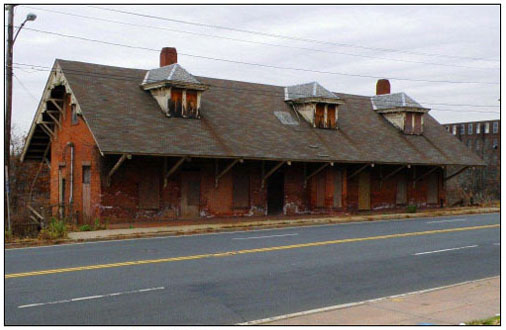
Source: Parsons Brinkerhoff, 2011
Potential adverse visual impacts at proposed new stations are as follows:
- Wallingford Station: The height of the proposed pedestrian overpass at the Wallingford Parker Street station alternative site would have potential adverse visual impact to 6 to 8 residences east of the rail line along North Colony Road, and about 10 row homes across from the North Cherry Street parcel. The Judd Square alternative site is in proximity to existing multi-story buildings and would not cause visual impact.
- Newington Station: Removal of the National Register-listed Newington Junction Depot building would result in an adverse visual impact in the station's vicinity. Impacts are identified and mitigation is recommended in the Cultural Resources Section of this EA/EIE.
- Windsor Station: The parking structure proposed with this new station would be considerably larger than other buildings in the station's vicinity. Depending on the structure's architecture it may have an adverse visual impact on views of the historic buildings and streetscapes along Broad Street in the Broad Street Green Historic District (Figure 4-6).
Figure 4-6 - Windsor CT Train Station
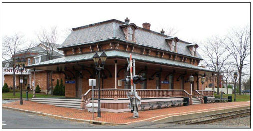
Source: Parsons Brinkerhoff, 2011
- Enfield Station: The height of the proposed pedestrian overpass would have potential adverse visual impacts to the Casket Building, which has been designated potentially eligible for listing in the National Register.
In summary, the effects of the action could be to introduce new structures that would cause an adverse visual impact either by being visually inconsistent with the existing visual context or by blocking views of the existing surroundings.
Mitigation
Based on a final determination of effect made by FRA, measures to mitigate potential adverse visual impacts of the improved, relocated, and new stations discussed above may include landscaping (including densely placed plantings to screen direct views of Wallingford Station from adjacent homes) and using building construction materials, colors and architectural styles consistent with station sites' surroundings, to the extent possible. Measures to mitigate potential adverse visual impacts affecting the integrity of historic properties will be developed in consultation with the Connecticut SHPO, as part of the Section 106 consultation process (see Section 4.4.7).
4.4.7 Cultural Resources
Summary
The NHHS rail corridor runs through an area of southern New England that has been the scene of human habitation for some 12,000 years. Consequently, the area is rich in pre-Colonial archaeological sites, historic-period archaeological sites, historic districts and individual historic properties. Archaeological resources have not yet been identified; therefore, impacts cannot be fully evaluated at this time because a majority of the proposed project's infrastructure improvements have been only conceptually designed or have not yet advanced to that stage. A PA among the FRA, FTA, CTDOT, CTSHPO, MASHPO, and other interested parties is being developed in accordance with 36 CFR § 800.4(b)2. The PA implements a phased process for further consultation among FRA, CTDOT, CTSHPO and other interested parties; identification of historic properties that may be affected by individual elements of the proposed project; and resolution of all adverse effects to historic properties that may result with the proposed project. The Draft Programmatic Agreement is included as Appendix 9. Details on the archaeological and historical resources that could be impacted are contained in the Technical Report on Cultural Resources.
Applicable Law
In addition to Federal and state laws cited in earlier sections, the following apply:
- Section 106 of the National Historic Preservation Act of 1966, as amended (16 USC 470f). Section 106 requires that Federally funded or permitted projects take into account the effects of their undertakings on historic and archaeological resources listed in or eligible for listing in the National Register of Historic Places (NHRP).
- Section 4(f) of the Department of Transportation Act of 1966 (49 USC 303). Section 4(f) states that the Secretary of the U.S. DOT may approve a transportation program or project requiring the use of land from an historic site of national, state or local significance (as determined by the Federal, state or local officials having jurisdiction over the site) only if:
- There is no feasible and prudent alternative to using that land, and
- The program or project includes all possible planning to minimize harm to the Section 4(f) property.
OR
The Section 4(f) use is de minimis.
- Massachusetts General Law, c. 9, ss. 26-27c. ("Antiquities Act" 950 CMR 70.00 and 950 CMR 71.00). The purpose of M.G.L. c. 9, ss. 26-27c is to eliminate, minimize, or mitigate adverse effects to properties listed in the Massachusetts State Register of Historic Places. 950 CMR 70.00 establishes a standardized system for conducting archaeological investigations in Massachusetts. 950 CMR 71.00 creates a uniform system for notification of MASHPO of projects that may affect, directly or indirectly, any property listed in the State Register of Historic Places.
Methodology Applied
Historic Properties
The National Register Criteria of Significance were applied to the potentially eligible resources. The Criteria state:
The quality of significance in American history, architecture, archaeology, engineering, and culture is present in districts, sites, buildings, structures, and objects that possess integrity of location, design, setting, materials, workmanship, feeling, and association, and:
- That are associated with events that have made a significant contribution to the broad patterns of our history; or
- That are associated with the lives of persons significant in our past; or
- That embody the distinctive characteristics of a type, period, or method of construction, or that represent the work of a master, or that possess high artistic values, or that represent a significant and distinguishable entity whose components may lack individual distinction; or
- That have yielded or may be likely to yield, information important in history or prehistory.
Archaeological Resources
In order to assess the potential for archaeological (i.e., subsurface) resources to be present within the project area -- the Area of Potential Effect (APE) -- a Phase IA Archaeological Assessment Survey was conducted. In consultation with MASHPO and CTSHPO, the CTDOT has defined the APE for the proposed project as the existing Amtrak rail ROW between New Haven Union Station (MP 0.00) and Springfield Union Station (MP 61.95), as well as additional property adjacent to grade crossings, the three siding locations, the sites of stations proposed to be constructed or improved, and the Springfield layover and maintenance facility (MP 62.90) (Figures 4.7 through 4.12). The survey was conducted in accordance with CTSHPO's Environmental Review Primer for Connecticut's Archaeological Resources and Massachusetts' M.G.L. c. 9, ss. 26-27c, 950 CMR 70.00, and 950 CMR 71.00. The survey also complied with The Secretary of the Interior's Standards and Guidelines for Identification and The Secretary of the Interior's Standards and Guidelines for Evaluation (1983 and ongoing revisions).
Figure 4-7 - Archaeologically Sensitive Area at Wallingford 2
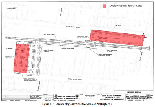
Figure 4-8 - Archeologically Sensitive Area at Berlin
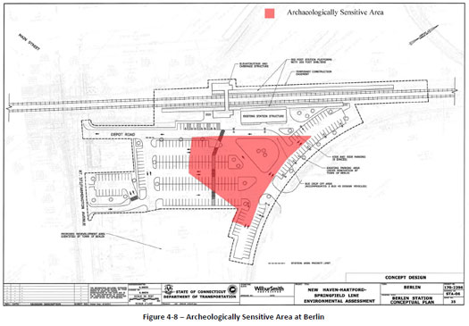
Figure 4-9 - Archeologically Sensitive Area at Windsor
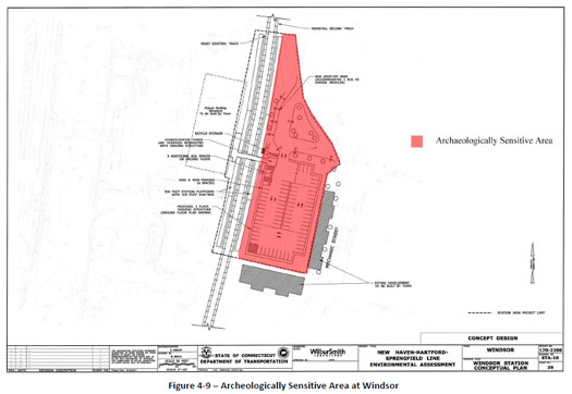
Figure 4-10 - Archaeologically Sensitive Area at Windsor Locks 1
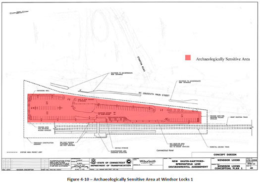
Figure 4-11 - Archeologically Sensitive Area at Enfield
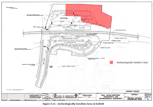
Figure 4-12 - Archaeologically Sensitive Area at Springfield Layover
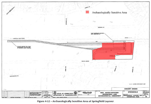
The purpose of the Phase IA survey was to determine if any known archaeological sites have been reported within or adjacent to the APE and to assess the potential for undocumented archaeological sites to be present in the APE. This assessment was based on documentary data and on environmental characteristics associated with pre-Colonial (pre-1630) Native American sites. No subsurface testing was conducted for this service-level EA/EIE because of the large scale of the project and because the project is in the early design phase and project parameters may change. Phase IB testing would be necessary for confirming whether buried archaeological sites are actually present within the APE.
The Phase IA Archaeological Assessment Survey included the following tasks:
- Background research in the CTSHPO/Office of State Archaeology (OSA) and MASHPO site files of reported archaeological sites and historic resources including those listed in the State and National Registers of Historic Places; in published and unpublished reports, articles and books on the history and archaeology of the APE; in historical maps; and in environmental sources. The research was performed to identify previously reported archaeological sites, to determine the APE's potential to contain unreported archaeological sites, and to help interpret any identified cultural resources in appropriate pre-Colonial Native American and historic-period contexts.
- Visual inspection of the APE in December 2011 via vehicular and pedestrian surveys. Areas of reported archaeological sites in or adjacent to the APE were viewed, and areas of potential archaeological sensitivity--i.e., areas which may contain intact pre-Colonial Native American or historic-period (post-1630) sites-- were identified. Indicators of archaeological sensitivity included above-ground cultural remains suggestive of archaeological sites (e.g., foundation ruins), as they may have associated subsurface components. Areas with certain environmental characteristics, such as undisturbed well-drained, relatively level locations in proximity to water sources or wetlands, have moderate to high potential for pre-Colonial Native American sites. Wetlands, areas of slope in excess of 15 percent, extremely stony soils, and excessively disturbed areas have low archaeological potential.
- Synthesis of the background research and walkover survey results to identify areas within the APE with an elevated potential to contain significant archaeological resources that may be affected by the proposed project.
Built Environment Including Buildings and Structures
For an overall historic context, the project historian consulted general statewide and local published histories that cover the communities along the NHHS rail corridor and standard works on New England railroad history. Inventories of historic resources that were consulted include the NRHP and a privately compiled guide to historic railroad stations and freight houses. Site-specific resources included railroad track maps from the late 19th century to ca.1950, Sanborn insurance maps, annual reports of the Hartford and New Haven Railroad and the New York, New Haven & Hartford Railroad, Shoreliner and other publications of the New Haven Railroad Historical and Technical Association and early- to mid-20th century aerial photographs.
The project historian participated in a field inspection of all single-track sections of the corridor in December 2011. All areas of station construction, both new construction and modifications to existing stations, were field-inspected by the project historian and the historical archaeologist. All grade crossings in built-up areas were visited to evaluate possible impacts on adjacent historic buildings and districts.
Data on bridges were compiled from Amtrak's current bridge list, as well as earlier bridge lists dating back to 1918. Bridges were individually inspected to verify the approximate dates of construction and existing condition when the inventory data appeared out-dated or incomplete. Bridges had to be field-verified.
The APE for historic properties is similar to that delineated for archaeological resources: the existing Amtrak rail ROW between New Haven Station and Springfield Station, as well as additional property adjacent to grade crossings, the three siding locations, the existing and newly proposed station sites, and the Springfield layover and maintenance facility. In the case of indirect visual effects on adjacent or nearby historic districts and other historic properties, the APE extends to the historic property.
The research and analysis of historic properties was carried out in accordance with The Secretary of the Interior's Standards and Guidelines for Identification and The Secretary of the Interior's Standards and Guidelines for Evaluation (1983 and ongoing revisions).
Existing Conditions - Archaeological Resources
The rail ROW APE is characterized by a built-up man-made environment, which includes tracks, bridges, culverts, embankments and other features that are part of the existing rail infrastructure. Station locations encompass varied landscapes, including industrial, urban, and suburban settings, parks, and rural areas.
Known Pre-Colonial Archaeological Sites near Connecticut APE
Review of the Connecticut state archaeological site files indicates that there are 104 recorded pre-Colonial archaeological sites within 1 mile of the APE. No pre-Colonial sites have been reported directly within the Connecticut APE.
Five pre-Colonial sites have been reported within approximately 250 feet of the APE centerline:
Site 101-12, also known as the State Street Site, is located on the west side of the Quinnipiac River in North Haven. Diagnostic projectile points surface-collected here indicate Archaic and Woodland-Period occupations. Site 101-12 is on the western border of the APE.
Site 101-28, known as the Paris Farm Site, is located in North Haven. It is a pre-Colonial site of unknown age near the Quinnipiac River west of the APE.
Site 101-34, known as the Cow Meadow Site, is located in North Haven. On the western APE margin, it is a pre-Colonial site of unknown age, situated on the terrace of the Quinnipiac River.
Site 148-2 is the Meetinghouse Brook Site, located in Wallingford, Connecticut. Adjacent to the east side of the railroad tracks, Site 148-2 is on the east side of Meetinghouse Brook near its confluence with Wharton Brook. Based on diagnostic projectile points recovered by the Connecticut Archaeological Society, this multicomponent site reflects Early and Late Archaic Period occupations, in addition to Early and Late Woodland Period occupations. A possible cremation burial was identified here, as well.
Site 148-5, also known as the Barnes Nursery, is located in Wallingford, Connecticut. It is a pre-Colonial site of unknown age, situated on the west side of Meetinghouse Brook near its confluence with the Quinnipiac River. It lies just west of the APE.
The site-file data indicate that undisturbed portions of the Connecticut APE, especially those near the Connecticut and Quinnipiac rivers, possess moderate to high archaeological sensitivity for pre-Colonial archaeological resources. However, undisturbed sediments represent a very small percentage of the total APE. Extensive soil displacement associated with the construction, modification, and demolition of rail lines, buildings, and structures has likely destroyed most of the pre-Colonial period archaeological deposits within the ROW.
Known Pre-Colonial and Contact Period Archaeological Resources in Massachusetts
Five pre-Colonial, ancient Native American archaeological sites are reported in MASHPO site files in the APE vicinity. No pre-Colonial sites are known directly within the Massachusetts APE.
19-HD-153 (Raspberry Brook Outlet Site). Located 2 miles west of the APE on a bluff on the eastern bank of the Connecticut River, on the Massachusetts/Connecticut state line, this Late Archaic/Woodland Period site was reported in 1980 based on a collection inventory.
19-HD-207 (Prehistoric Findspot F). Located 400 meters east of the Connecticut River and west of the APE, this pre-Colonial site, evidenced by non-diagnostic lithics and fire-cracked rock, was identified in a gas pipeline survey.
19-HD-213 (West Road Site). Adjacent to 19-HD-207, this Woodland-period site was also identified in a gas pipeline survey; its date is based on the recovery of Native American ceramics and lithic flakes. The site was noted as intact and potentially eligible for listing in the NRHP.
19-HD-271 (LMW-2 Findspot). On the east side of the APE, this site is represented by a single lithic flake.
19-HD-292 (Beech Spring Site). East of the APE in Forest Park, this site produced 166 artifacts inclusive of lithic flakes, biface fragments, a groundstone tool fragment and a small number of bone or antler fragments.
Three Contact-period (1500-1676) sites were reported near the Massachusetts rail line APE:
19-HD-82.This site, which the site form describes as an "Indian fort at the time of King Philip's War," is on the top of a high bluff on the east side of the Connecticut River, almost directly opposite the mouth of the Westfield River. Recorded by the Massachusetts Archaeological Society in 1940, the site is believed to have been destroyed by the construction of I-91 and other development.
19-HS-83 (King Philip's Stockade Site). This site was originally recorded by the Massachusetts Archaeological Society in 1940, on "a height of land" in Forest Park, based on the recovery of a "few artifacts" in paths and flower beds. Oral tradition indicated it was a "lookout for King Philip." On a high point overlooking the Connecticut River, on the west side of Route 5, the site was investigated archaeologically in 1986. The 1986 survey recovered 63 lithics, none diagnostic, over a 100 x 250 meter area; MASHPO noted on the site form that "it is estimated that the entire area consists of a series of sites."
19-HD-151 (Fort Hill). This very important site of a Contact-period and probable earlier period palisaded village was first reported in 1979. The University of Massachusetts conducted investigations in 1990 and found evidence confirming its King Philip War-era component (European flint and trade goods). This important site, with evident integrity, is "one of few known palisaded villages in southern New England."
No Contact-period sites are reported directly within the Massachusetts APE.
Known Historic-Period Archaeological Sites in or near Connecticut APE
Review of the Connecticut state archaeological site files indicates that there are 21 recorded historic-period archaeological sites within 1 mile of the APE.
Much like the pre-Colonial sites, these historic sites tend to be clustered along the Quinnipiac and Connecticut rivers, which have served as primary arteries of settlement and industry during the historic period. These resources reflect a variety of functions from various time frames. For example, one is the purported location of William Pynchon's 17th-century trading post in Enfield. Evidence of 18th-century maritime heritage is preserved at Long Wharf in New Haven. Nineteenth-century industrial complexes are represented by sites such as the Windsor Locks Gas Works and the Franklin Paper Mill in Suffield.
Two historic-period sites are within or adjacent to the APE (i.e., within 250 feet of the APE centerline):
Site 93-25 is located along Long Wharf Drive in the City of New Haven. This site, historically known as "Long Wharf" or "Union Wharf," served as a major hub for maritime commerce from the 18th through the 19th centuries. Mid-20th century harbor filling associated with the construction of Interstate Highways 91 and 95 and a massive urban renewal project moved the waterfront. Consequently, the area of the original Long Wharf has been largely re-developed for commercial purposes. However, historical and archaeological investigations have established that elements of the Long Wharf's early 19th-century stone masonry lie intact beneath the modern riprap, and may extend into the APE.
Site 93-24A is the Spring Street Roundhouse Site, located in New Haven, east of the main rail line. This site was found to contain numerous features/structural remains associated with a railroad roundhouse constructed in 1870, which was part of a larger repair-shop complex built by the New York and New Haven Railroad.
The historic-period archaeological site data highlight the probability that portions of the APE may have the potential to contain subsurface remains of rail-related features, such as buried and filled turntable pits and maintenance bays, even in areas of surficial disturbance. This is because such large, deep rail yard components were often filled and buried after their above-ground superstructures were removed. Other historic-period sites may also extend into the APE.
Known Historic-Period Archaeological Sites near Massachusetts APE
SPR-HA-1 (Springfield Waste Company Dam Remnant Site). East of the APE at the rear of 91-99 Mill Street are the brownstone remains of the 19th-century Springfield Waste Company Dam along the Mill River.
SPR-HA-2 (Bangs' Dam Remnant Site). On the Mill River at the rear of 41 Mill Streetare the remains of a brownstone dam associated with early 19th-century industrial enterprises.
SPR-HA-03 (The Quadrangle Site). On the grounds of the Springfield Science Museum east of the APE, archaeological investigations recovered remains of an early-19th-century dwelling.
SPR-HA-05 (Springfield Federal Courthouse). Archaeological survey identified a cistern associated with the 19th-century Alexander House; the cistern was filled with historic household-related refuse.
SPR-HA-06 (J. Madden Brickyard). This early-19th-century site of two "open Dutch" kiln remains was identified in Forest Park, east of the APE.
SPR-HA-07 (Coomes Dwelling). East of the APE, an archaeological study in Forest Park identified the brick remains of a mid-19th-century dwelling with apparently intact subsurface components.
Existing Conditions - Above Ground Architectural and Engineering Resources
The NHHS rail corridor is located in one of the earliest-settled and most densely developed areas of New England. Consequently, the corridor runs through or immediately abuts recognized historic districts in nearly every town through which it passes, and numerous other individual historic properties are located nearby. Many of these are specifically cited in the Impacts section, below, but a few examples here will suffice to indicate the overall density of historic resources in the vicinity of the project:
- New Haven: Wooster Square and Ninth Square historic districts (near the APE), two significant 19th-century residential and commercial areas, and the Strouse-Adler Corset factory (adjacent to the APE), an industrial complex dating from 1860;
- Wallingford: Wilson Sewing Machine Company factory (adjacent to the APE), a large brick industrial complex built in 1883 and enlarged by the New York Insulated Wire Works around 1900;
- Meriden: The Colony Street-West Main Street Historic District (adjacent to the APE), the historic commercial core of Meriden;
- Berlin: The Berlin Construction Company shops (adjacent to the APE), an industrial complex started in 1902 by one of the region's most prolific bridge-building and steel-fabrication companies;
- Hartford: Bartholomew Avenue factories (adjacent to the APE), a classic late-19th-century industrial district that grew up specifically to take advantage of rail access. Other notable Hartford resources include Bushnell Park (adjacent) and the Clay Hill Historic District, a residential-commercial area bisected by the rail line at its southeast corner;
- Windsor: Broad Street Green Historic District, a commercial/institutional center for the town that owed its existence to the siting of passenger and freight rail facilities;
- Windsor Locks: The Enfield (Windsor Locks) Canal and associated historic factory buildings. The NHHS rail corridor parallels the canal for about 2 miles before crossing it;
- Enfield: The Bigelow-Hartford Carpet Mills Historic District in Thompsonville, an area dense with former textile mills that extends across the rail corridor; and
- Springfield: The Downtown Springfield Railroad Historic District, a dense concentration of commercial and institutional buildings that specifically references the defining role of the railroad in Springfield's historical development and through which the railroad passes.
The Connecticut River towns were first settled by the English in the mid-1630s, with Springfield remaining within the Massachusetts Bay Colony and Windsor, Hartford and Wethersfield forming the nucleus of the Connecticut Colony. New Haven was settled shortly thereafter, in 1638, and remained a separate colony until it was joined with the Connecticut Colony in 1664. These early towns extended over large geographic areas and were primarily agricultural in character, with small commercial enterprises occurring only at the core of settlement. Agricultural and extractive products such as lumber were the mainstay of the region's trade for many years, helping Springfield, Hartford, and New Haven grow as commercial centers for the products of the hinterland, as well as serving as administrative and judicial centers. Over the years, new towns were set off from the original towns: Wallingford from New Haven in 1670, Enfield from Springfield in 1683 (annexed to Connecticut in 1749), East Windsor from Windsor in 1768, Longmeadow from Springfield in 1783, Berlin from Wethersfield (and parts of Farmington and Middletown) in 1785, Hamden and North Haven from New Haven in 1786, West Hartford from Hartford and Windsor Locks from Windsor in 1854, and Newington from Wethersfield in 1871. Some of these towns subsequently gave birth to additional towns: Meriden was part of Wallingford until 1806, and New Britain was incorporated from Berlin in 1850.
In the late 18th and early 19th centuries, the towns along what would become the NHHS rail corridor began to be transformed by industrial development. New Haven was an early focus of carriage-building, Berlin pioneered with tinware and other sheet-metal products, and America's first industrial-scale silverware and silver-plate enterprises appeared in Hartford, Meriden and Wallingford. Textile manufacture, in the form of specialized woolen goods, began on a large scale in Thompsonville (Enfield) after changes in the tariff laws in the 1820s. The manufacture of firearms, machine tools, and cast and stamped hardware of every description soon defined a major metalworking sector extending from Springfield all the way to New Haven.
It is doubtful that the tremendous industrial expansion that characterized the corridor beginning in the second half of the 19th century, and the accompanying commercial and residential growth that extended well through the 20th century, would have occurred at the scale it did without the construction of exceptional access to the nation's railroad network. Or, from another point of view, it is doubtful that one of the region's earliest rail lines would have been built to connect New Haven, Hartford, and Springfield had not these cities already established themselves as commercial and industrial centers. Thus, they are inextricably tied. Industry, urban growth, and railroad development were tightly bound up in a symbiotic relationship that defies simple linear cause-and-effect explanation.
The rail line between New Haven and Hartford was the most important of several lines chartered by the State of Connecticut in the early 1830s. Jointly promoted by the mercantile interest of those two cities, who were often rivals but saw a common benefit to a rail line linking the Connecticut River and Long Island Sound, the Hartford & New Haven Railroad was chartered and 1833 and laid out by the noted engineer Alexander Twining. The Depression of 1837 caused construction to halt, but by 1838 the track had been built through Meriden, arriving in Hartford a year later. From the beginning, the proponents had envisioned the line running through to Springfield and, in December 1844, the Springfield extension went into service. For the first few years, the line ended at the water in New Haven, obliging passengers to transfer to steamboats for the subsequent journey to New York City. In 1848, another railroad, the New York & New Haven, completed its service between those two cities. For more than 40 years, the corridor served as the only all-rail route between Boston and New York; it was not until 1889 that a somewhat faster all-rail shoreline route was completed, challenging the NHHS corridor as southern New England's main passenger artery.
In addition to the passenger and freight business generated by the communities along its route, the corridor benefited from numerous intersecting rail lines. In the late 1840s and early 1850s, an east-west line from Providence to Waterbury was completed, running parallel to the corridor for several miles through Hartford and Newington. The Hartford, Providence, and Fishkill Railroad later came under the control of the Boston, Hartford & Erie and then the New York & New England railroads. Other intersecting lines were built by proponents from cities that had been left out of the initial round of railroad construction. Middletown interests built a branch that connected their city with the corridor in 1848, and New Britain followed suit in 1865; both branches were operated by and eventually controlled by the Hartford & New Haven. In 1869, the Connecticut Western was begun to link Hartford with communities in Connecticut's Litchfield Hills.
In 1872, the New York & New Haven and the Hartford & New Haven merged to form the New York, New Haven & Hartford Railroad, establishing the company that would dominate transportation in southern New England until the Penn Central merger of 1968. Popularly known as the New Haven or the Consolidated, the line built little additional track, but through leases and acquisitions came to monopolize not only rail transportation in the region but steamboat service and, eventually, streetcars and buses, as well.
The emerging monopoly of the New Haven Railroad caused some business leaders to try to circumvent it with competing rail lines. Meriden manufacturers built lines to Cromwell and Waterbury in 1883 and 1888, where they would connect with lines still independent of the New Haven. However, the Crowell end came under the New Haven's control in 1887 and the Waterbury junction and the rest of the Meriden branch in 1898. A similar course ensued when the Connecticut Central (Springfield and New London in Massachusetts) attempted to build a parallel line from Springfield to East Hartford in 1876. After only a few years of independent operation, it came under the control of the New York & New England; in 1898, it was merged into the New Haven system. Known as the Armory Branch, part of the now-abandoned line runs through the proposed site of the Springfield layover/maintenance facility site. By 1900, the New Haven controlled virtually all the rail traffic in Connecticut, Rhode Island, and southern Massachusetts.
In 2009, CTSHPO expressed its opinion that the entire NHHS rail corridor within Connecticut is eligible for listing in the NRHP as a linear historic district. Logically, the eligible linear historic district extends to Springfield. The same types of historic resources - bridges and culverts, a signal tower, and an historic railroad station - are found in the portion of the project in the Commonwealth, and MASHPO has concurred with the concept of the entire historic rail corridor as a linear historic district. The components of the eligible linear historic district include the following:
- Historic passenger stations, freight houses, signal towers adjacent to the corridor. Although all were formerly railroad property and directly related to the presence of the railroad in their respective communities, today most are privately owned and in use for other purposes. Amtrak continues to maintain waiting areas and ticket facilities at historic stations in New Haven, Berlin, Hartford, and Springfield, while Wallingford and Windsor are in use as unattended station stops. Table 4-19 lists the historic buildings that contribute to the eligible linear historic district.
Table 4-19 - Rail Related Buildings that Contribute to the Historic New Haven-Springfield Rail Line
| Approx. Milepost | Name | Location | Date | NR Status |
|---|---|---|---|---|
| 0.00 | New Haven Union Station | 50 Union Avenue, New Haven | 1920 | Listed 9/3/1975 |
| 0.20 | Substation | Union Avenue, south of Route 34, New Haven | ca.1955 | Recommended as contributing |
| 2.38 | New Haven Railroad YMCA | 1435 State Street, New Haven | 1944 | Recommended as contributing |
| 7.25 | North Haven Freight House | 81 Old Broadway, North Haven | 1860 | Listed 5/27/19881 |
| 7.30 | North Haven Passenger Station | 81 Old Broadway, North Haven | ca.1875 | Listed 5/27/19881 |
| 12.60 | Wallingford Railroad Station | 7 Hall Avenue, Wallingford | 1871 | Listed 11/19/1993 |
| 12.70 | Wallingford Freight House | 105 North Cherry Street, Wallingford | ca.1910 | Recommended as contributing |
| 25.80 | Berlin Passenger Station | 51 Depot Road, Berlin | 1900 | Recommended as contributing |
| 31.70 | Newington Freight House | 200 Francis Avenue, Newington | ca. 1870 | Listed 12/22/19862 |
| 36.60 | Hartford Union Station | 1 Union Place, Hartford | 1889 | Listed 11/25/1975 |
| 37.10 | Tower S.S. 214 | North of Union Station, Hartford | ca.1900 | Recommended as contributing |
| 42.90 | Windsor Freight House | 50 Central Street, Windsor | ca.1871 | Listed 9/15/19883 |
| 42.95 | Windsor Passenger Station | 41 Central Street, Windsor | 1871 | Listed 9/15/19883 |
| 48.70 | Windsor Locks Passenger Station | North Main Street, Windsor Locks | 1875 | Listed 9/2/1975 |
| 49.90 | Warehouse Point Freight House | 4 Old Depot Hill Road, Enfield | 1872 | Recommended as contributing |
| 61.50 | Tower S.S. 274 | I-91 overpass, Springfield | ca.1900 | Recommended as contributing |
| 61.95 | Springfield Union Station | 55 Frank B. Murray Street, Springfield | 1926 | Listed 5/27/19834 |
1 Listed as a contributing component of the Pines Bridge Historic District
2 Listed as part of the Newington Junction Multiple Resource Area
3 Listed as part of the 18th and 19th Century Brick Architecture of Windsor Thematic Resource
4 Listed as a contributing component of the Downtown Springfield Railroad District
Many of these buildings are already listed on the NRHP, individually and/or as contributing components to historic districts. The buildings have great local historical significance because they recall the importance of rail access in the history of the various communities along the line. The railroad represented not only an economic connection, bringing in fuel and raw materials and allowing local industries to reach a wide market, but also a social connection: the local railroad depot was where the community met friends and family coming to visit, and said farewell to residents leaving for school and military service. In many cases, the railroad buildings also have architectural significance, illustrating particular styles of architecture and built of exceptionally substantial materials. In the case of large urban stations, the buildings represent designs by architects of state and national prominence.
Many of the rail-related buildings lie within NRHP historic districts or Multiple Resource Areas that specifically reference the importance of rail transportation in the community's historical development: the Colony Street-West Main Street Historic District in Meriden, the Newington Junction Multiple Resource Area in Newington, the Broad Street Green Historic District in Windsor and the Downtown Springfield Railroad District in Springfield. In each case, the location of railroad passenger and freight facilities resulted in a shift away from earlier centers of settlement toward the area surrounding the rail facilities. In these cases, railroad stations are key heritage resources, without which much of the meaning of the surrounding historic areas would be lost.
Most of the rail-related buildings have retained their historical appearance substantially intact, but even in cases where there have been alterations, the buildings listed in Table 4-19 retain enough integrity that their age, historic function and original architectural character are clearly evident. For resources that are not already listed on the NRHP, the recommendation in Table 4-19 is that the building contributes to the NHHS rail corridor as an eligible linear historic district; in nearly all cases, the building would also be individually eligible because of its importance in local history.
One railroad station, Longmeadow, was not included among the contributing buildings because of a lack of integrity of location and design.
- Bridges and culverts. Along the NHHS rail corridor are dozens of bridges that are more than 50 years old, which are recommended as contributing to the eligible linear historic district if they retain sufficient integrity of design and materials such that their age and original function are apparent. Some, such as the Farmington River Bridge in Windsor (1867) or the Connecticut River Bridge between Windsor Locks and East Windsor (1904), represent significant works of engineering. Others, such as the numerous smaller stone arches and ca. 1900 plate-girder bridges, are significant as examples of the typical railroad engineering of their periods. These bridges are also significant because they illustrate the ongoing rebuilding of the line to meet new transportation needs. It is unlikely that much from the original 1830s and early 1840s construction remains. Like most early Connecticut railroads, the corridor was initially hastily built, with wooden rails topped with strap-iron and a single line of track. The line was substantially rebuilt with standard-profile iron- T-rail in the 1840s and, from the 1840s through 1872; the line was steadily double-tracked to provide more capacity. Another great round of improvements occurred in the years around the turn of the century, when the heavier weight of the period's steam locomotives demanded stronger bridges, and the managerial team of Charles S. Mellen and J.P. Morgan wanted to invest heavily in both acquisitions and infrastructure improvements. Table 4-20 lists the bridges along the line that are more than 50 years old. A few have been recommended as noncontributing to the eligible linear historic district because they have been so substantially altered that they no longer retain integrity of design or materials.
The construction and upgrading of the rail line required numerous culverts to accommodate smaller streams and drainage along the route. Culverts are undated in railroad records but can be approximately dated from similar examples along lines that received few improvements and similarities in masonry to dated stone bridges. Table 4-21 lists the culverts that are likely to be more than 50 years old. Those that have one or both sides relatively intact have been recommended as contributing components to the linear historic district; those that have been buried or completely embedded in late construction have been recommended as noncontributing. The table excludes structure types that are essentially identical to modern types, such as steel and concrete pipes and corrugated-metal arches.
Table 4-20 - Bridges that Potentially Contribute to the Historic New Haven-Springfield Rail Line
| Milepost | Name | Town | Date | Type | NR Status |
|---|---|---|---|---|---|
| 0.26 | Pipe bridge | New Haven | ca.1900 | Truss | Recommended as contributing |
| 1.36 | East Street Signal Bridge | New Haven | 1906 | Truss | Recommended as contributing |
| 1.48 | Mill River | New Haven | 1906 | Concrete arch | Recommended as contributing |
| 1.61 | Humphrey Street | New Haven | 1910 | Concrete-encased beams | Recommended as contributing |
| 1.73 | James Street | New Haven | 1905 | Plate-girder | Recommended as contributing |
| 2.14 | Ferry Street | New Haven | 1912 | Truss | Eligible1 |
| 2.36 | Railroad YMCA Footbridge | New Haven | 1944 | I-beam | Recommended as contributing |
| 2.61 | Yard Footbridge | New Haven | 1913 | Truss, 3 spans | Recommended as contributing |
| 6.34 | Stream | North Haven | ca.1870 | Stone arch | Recommended as contributing |
| 7.03 | Quinnipiac River | North Haven | 1903 | Plate-girder, 4 spans | Recommended as contributing |
| 7.46 | Stream | North Haven | ca.1870 | Stone arch | Recommended as contributing |
| 9.18 | Pratt & Whitney | North Haven | 1951 | I-beam | Recommended as contributing |
| 9.80 | Defco Park Road | North Haven | 1961 | I-beam | Recommended as contributing |
| 10.46 | Wharton Brook | Wallingford | 1856 | Stone arch | Recommended as contributing |
| 12.91 | Stream | Wallingford | ca.1915 | Rail top | Recommended as contributing |
| 13.96 | Stream | Wallingford | 1908 | Concrete arch | Recommended as contributing |
| 15.00 | Stream | Wallingford | 1901 | Rail top | Noncontributing; lack of integrity |
| 15.14 | Wilbur Cross Parkway | Wallingford | 1947 | I-beam | Recommended as contributing |
| 15.26 | Falls Brook | Wallingford | ca.1900 | Concrete beam | Recommended as contributing |
| 15.66 | Route 150 | Wallingford | ca.1870 | Stone arch | Eligible1 |
| 16.78 | Gypsy Lane | Meriden | 1909 | I-beam | Recommended as contributing |
| 18.01 | South Colony Street | Meriden | 1907 | Plate-girder | Recommended as contributing |
| 18.48 | Harbor Brook | Meriden | 1904 | Plate-girder | Recommended as contributing |
| 18.72 | Clark Brook | Meriden | ca.1915 | Rail top | Recommended as contributing |
| 18.99 | Camp Street | Meriden | 1899 | Plate-girder | Recommended as contributing |
| 19.20 | Stream | Meriden | ca.1915 | Rail top | Recommended as contributing |
| 19.90 | Meriden-Waterbury Branch | Meriden | ca.1900 | Plate-girder | Recommended as contributing |
| 20.83 | Stream | Meriden | ca.1870 | Stone arch | Recommended as contributing |
| 21.12 | Yales Bridge | Meriden | 1939 | Stone abutment only | Noncontributing; lack of integrity |
| 22.53 | Belcher Brook | Meriden | ca.1870 | Stone arch | Recommended as contributing |
| 22.75 | Belcher Brook | Meriden | ca.1900 | Brick arch | Recommended as contributing |
| 23.76 | Meriden Brook | Berlin | ca.1870 | Stone arch | Recommended as contributing |
| 24.85 | Norton Brook | Berlin | ca.1870 | Stone arch | Recommended as contributing |
| 25.52 | Mill River | Berlin | 1870 | Stone arch, 8 spans | Recommended as contributing |
| 26.39 | Willow Brook | Berlin | ca.1870 | Stone arch, 4 spans | Recommended as contributing |
| 27.83 | Webster Brook | New Britain | ca.1870 | Stone arch | Recommended as contributing |
| 28.57 | Webster Brook | Newington | ca.1915 | Rail top | Recommended as contributing |
| 30.99 | Newington River | Newington | 1904 | Plate-girder | Recommended as contributing |
| 32.90 | New Britain Avenue | West Hartford | 1958 | Plate-girder | Recommended as contributing |
| 33.07 | Noyes River | West Hartford | ca.1870 | Stone arch | Recommended as contributing |
| 34.53 | Smith Brook | Hartford | ca.1870 | Stone arch | Recommended as contributing |
| 35.15 | Park Street | Hartford | ca.1910 | Plate-girder | Recommended as contributing |
| 35.41 | Park River | Hartford | 1911 | Stone arch | Recommended as contributing |
| 35.51 | Capitol Avenue | Hartford | 1924 | Plate-girder | Recommended as contributing |
| 36.52 | Asylum Street sidewalk | Hartford | 1926 | Concrete arch | Recommended as contributing |
| 36.53 | Asylum Street | Hartford | 1918 | Plate-girder | Recommended as contributing |
| 36.55 | Hartford Station Viaduct | Hartford | 1889 | Plate-girder, 25 spans | Listed as part of station |
| 36.66 | Church Street | Hartford | 1889 | Plate-girder, 2 spans | Recommended as contributing |
| 37.03 | Main Street and Albany Avenue | Hartford | 1871 | Brick-arch tunnel | Listed2 |
| 37.35 | Windsor Street | Hartford | 1937 | Concrete beam, 2 spans | Recommended as contributing |
| 39.40 | Meadow Brook | Hartford | 1905 | I-beam | Recommended as contributing |
| 40.90 | Stream | Windsor | 1874 | Stone arch | Recommended as contributing |
| 41.62 | Stream | Windsor | ca.1900 | Brick arch | Recommended as contributing |
| 42.65 | Batchelder Road | Windsor | 1914 | Plate-girder | Recommended as contributing |
| 43.08 | Palisado Avenue | Windsor | 1917 | Plate-girder | Recommended as contributing |
| 43.18 | Mill Brook culvert | Windsor | ca.1910 | Concrete arch | Recommended as contributing |
| 43.30 | Farmington River | Windsor | 1867 | Stone arch, 8 spans | Listed 8/25/1972 |
| 46.78 | Waterworks Brook | Windsor Locks | ca.1900 | Brick arch | Recommended as contributing |
| 48.16 | Pipe bridge | Windsor Locks | 1930 | Truss | Recommended as contributing |
| 49.15 | Cannon Brook | Windsor Locks | ca.1900 | Brick arch | Recommended as contributing |
| 49.73 | Connecticut River | Windsor Locks | 1904 | Truss, plate-girder | Recommended as contributing |
| 51.66 | Beemans Brook | Enfield | ca.1900 | Brick arch | Recommended as contributing |
| 53.94 | Asnuntuck Street | Enfield | 1912 | Brick arch | Noncontributing; lack of integrity |
| 53.96 | Freshwater Brook | Enfield | ca.1900 | Brick arch | Recommended as contributing |
| 54.88 | Waterworks Brook | Enfield | ca.1900 | Brick arch | Recommended as contributing |
| 56.05 | Raspberry Brook | Longmeadow | 1910 | Brick arch | Recommended as contributing |
| 57.92 | Wheel Meadow Brook | Longmeadow | ca.1900 | Brick arch | Recommended as contributing |
| 59.53 | Pecousic Brook | Longmeadow | ca.1910 | Concrete arch | Recommended as contributing |
| 60.45 | Mill River | Springfield | 1919 | Concrete arch | Recommended as contributing |
| 60.15 | New South End Bridge (Route 5) | Springfield | 1953 | I-beam | Recommended as contributing |
| 60.45 | Mill River | Springfield | 1919 | Concrete arch | Recommended as contributing |
| 61.28 | Elm Street | Springfield | 1905 | I-beam | Recommended as contributing |
| 61.42 | Memorial Bridge (Route 20) | Springfield | 1922 | Concrete arch | Recommended as contributing |
| 61.71 | Columbus Avenue | Springfield | ca. 1910 | Plate-girder | Recommended as contributing |
| 61.81 | Main Street | Springfield | 1889 | Stone arch | Listed3 |
| 61.95 | Station subway | Springfield | 1922 | Plate-girder | Listed3 |
1 Recommended as individually eligible in the 1990 ConnDOT historic bridge inventory.
2 Listed as part of the Clay Hill Historic District; also considered individually eligible in the 1990 CTDOT historic bridge inventory.
3 Listed 5/27/1983 as part of the Downtown Springfield Railroad District. Part of the CSX main line.
Table 4-21 - Culverts that Potentially Contribute to the Historic New Haven-Springfield Rail Line
| Milepost | Name | Town | Date | Type | NR Status |
|---|---|---|---|---|---|
| 2.99 | Culvert for drainage | Hamden | ca.1870 | Stone box | Recommended as contributing |
| 3.75 | Culvert for drainage | Hamden | ca.1870 | Stone box | Recommended as contributing |
| 4.18 | Culvert for drainage | Hamden | ca.1870 | Stone box | Recommended as contributing |
| 4.61 | Culvert for drainage | Hamden | ca.1870 | Stone box | Noncontributing; lack of integrity |
| 4.86 | Culvert for drainage | Hamden | ca.1870 | Stone box | Recommended as contributing |
| 5.50 | Culvert for drainage | North Haven | ca.1870 | Stone box | Noncontributing; lack of integrity |
| 6.10 | Culvert for drainage | North Haven | ca.1870 | Stone arch | Recommended as contributing |
| 6.34 | Culvert for drainage | North Haven | ca.1870 | Stone arch | Recommended as contributing |
| 7.92 | Culvert for drainage | North Haven | ca.1870 | Stone box | Noncontributing; lack of integrity |
| 7.99 | Culvert for drainage | North Haven | ca.1870 | Stone box | Recommended as contributing |
| 11.31 | Culvert for drainage | Wallingford | ca.1910 | Iron pipe | Recommended as contributing |
| 13.82 | Culvert for drainage | Wallingford | ca.1870 | Stone box | Noncontributing; lack of integrity |
| 15.56 | Culvert for drainage | Wallingford | ca.1870 | Stone box | Recommended as contributing |
| 16.19 | Culvert for drainage | Wallingford | ca.1900 | Brick arch | Recommended as contributing |
| 16.70 | Culvert for drainage | Meriden | ca.1870 | Stone box | Recommended as contributing |
| 16.84 | Culvert for drainage | Meriden | ca.1900 | Brick arch | Recommended as contributing |
| 17.00 | Culvert for drainage | Meriden | ca.1900 | Brick arch | Recommended as contributing |
| 17.65 | Culvert for drainage | Meriden | ca.1870 | Stone box | Recommended as contributing |
| 17.75 | Culvert for drainage | Meriden | ca.1900 | Brick arch | Recommended as contributing |
| 18.27 | Culvert for drainage | Meriden | ca.1870 | Stone box | Noncontributing; lack of integrity |
| 18.72 | Culvert for drainage | Meriden | ca.1870 | Stone box | Noncontributing; lack of integrity |
| 19.41 | Culvert for drainage | Meriden | ca.1870 | Stone box | Noncontributing; lack of integrity |
| 19.70 | Culvert for drainage | Meriden | ca.1900 | Brick arch | Recommended as contributing |
| 20.25 | Culvert for drainage | Meriden | ca.1900 | Brick arch | Recommended as contributing |
| 20.83 | Culvert for drainage | Meriden | ca.1870 | Stone box | Noncontributing; lack of integrity |
| 21.49 | Culvert for drainage | Meriden | ca.1870 | Stone box | Noncontributing; lack of integrity |
| 21.83 | Culvert for drainage | Meriden | ca.1870 | Stone box | Recommended as contributing |
| 23.47 | Culvert for drainage | Berlin | ca.1870 | Stone box | Recommended as contributing |
| 23.80 | Culvert for drainage | Berlin | ca.1870 | Stone box | Recommended as contributing |
| 24.53 | Culvert for drainage | Berlin | ca.1870 | Stone box | Recommended as contributing |
| 25.70 | Culvert for drainage | Berlin | ca.1900 | Brick arch | Recommended as contributing |
| 27.66 | Culvert for drainage | New Britain | ca.1870 | Stone arch | Recommended as contributing |
| 28.35 | Culvert for drainage | New Britain | ca.1870 | Stone box | Recommended as contributing |
| 28.46 | Culvert for drainage | New Britain | ca.1870 | Stone box | Noncontributing; lack of integrity |
| 30.43 | Culvert for drainage | Newington | ca.1910 | Concrete arch | Recommended as contributing |
| 30.44 | Culvert for drainage | Newington | ca.1910 | Iron pipe | Recommended as contributing |
| 31.44 | Culvert for drainage | Newington | ca.1870 | Stone box | Recommended as contributing |
| 31.54 | Culvert for drainage | Newington | ca.1870 | Stone box | Recommended as contributing |
| 31.56 | Culvert for drainage | Newington | ca.1900 | Brick arch | Recommended as contributing |
| 31.93 | Culvert for drainage | Newington | ca.1870 | Stone box | Recommended as contributing |
| 33.75 | Culvert for drainage | West Hartford | ca.1870 | Stone box | Noncontributing; lack of integrity |
| 33.95 | Culvert for drainage | West Hartford | ca.1870 | Stone box | Noncontributing; lack of integrity |
| 34.17 | Culvert for drainage | Hartford | ca.1870 | Stone box | Noncontributing; lack of integrity |
| 34.23 | Culvert for drainage | Hartford | ca.1870 | Stone box | Noncontributing; lack of integrity |
| 36.99 | Culvert for drainage | Hartford | ca.1870 | Brick arch | Noncontributing; lack of integrity |
| 38.20 | Culvert for drainage | Hartford | ca.1900 | Brick arch | Noncontributing; lack of integrity |
| 38.53 | Culvert for drainage | Hartford | ca.1900 | Brick arch | Recommended as contributing |
| 38.79 | Culvert for drainage | Hartford | ca.1900 | Brick arch | Noncontributing; lack of integrity |
| 40.30 | Culvert for drainage | Windsor | ca.1870 | Double stone box | Recommended as contributing |
| 40.63 | Culvert for drainage | Windsor | ca.1870 | Stone box | Recommended as contributing |
| 41.27 | Culvert for drainage | Windsor | ca.1870 | Stone box | Noncontributing; lack of integrity |
| 41.77 | Culvert for drainage | Windsor | ca.1900 | Brick arch | Recommended as contributing |
| 42.02 | Culvert for drainage | Windsor | ca.1870 | Iron pipe | Recommended as contributing |
| 42.32 | Culvert for drainage | Windsor | ca.1870 | Stone box | Noncontributing; lack of integrity |
| 42.64 | Creamery Brook culvert | Windsor | ca.1870 | Stone box | Recommended as contributing |
| 42.68 | Culvert for drainage | Windsor | ca.1870 | Stone box | Recommended as contributing |
| 42.69 | Culvert for drainage | Windsor | ca.1900 | Brick arch | Noncontributing; lack of integrity |
| 44.10 | Culvert for drainage | Windsor | ca.1900 | Brick arch | Recommended as contributing |
| 44.55 | Culvert for drainage | Windsor | ca.1900 | Brick arch | Recommended as contributing |
| 45.25 | Culvert for drainage | Windsor | ca.1900 | Rail top | Recommended as contributing |
| 45.91 | Culvert for drainage | Windsor | ca.1870 | Iron pipe | Recommended as contributing |
| 46.18 | Culvert for drainage | Windsor | ca.1900 | Brick arch | Recommended as contributing |
| 47.56 | Culvert for drainage | Windsor Locks | ca.1900 | Brick arch | Noncontributing; lack of integrity |
| 47.70 | Culvert for drainage | Windsor Locks | ca.1870 | Iron pipe | Recommended as contributing |
| 47.75 | Culvert for drainage | Windsor Locks | ca.1910 | Iron pipe | Recommended as contributing |
| 47.85 | Culvert for drainage | Windsor Locks | ca.1900 | Ceramic pipe | Recommended as contributing |
| 47.90 | Culvert for drainage | Windsor Locks | ca.1900 | Ceramic pipe | Recommended as contributing |
| 48.18 | Culvert for drainage | Windsor Locks | ca.1900 | Brick arch | Noncontributing; lack of integrity |
| 48.42 | Culvert for drainage | Windsor Locks | ca.1900 | Iron pipe | Recommended as contributing |
| 48.65 | Culvert for drainage | Windsor Locks | ca.1900 | Ceramic pipe | Recommended as contributing |
| 48.75 | Culvert for drainage | Windsor Locks | ca.1870 | Stone arch | Noncontributing; lack of integrity |
| 48.87 | Culvert for drainage | Windsor Locks | ca.1870 | Stone box | Recommended as contributing |
| 48.92 | Culvert for drainage | Windsor Locks | ca.1870 | Stone box | Recommended as contributing |
| 49.30 | Culvert for drainage | Windsor Locks | ca.1900 | Ceramic pipe | Recommended as contributing |
| 49.40 | Culvert for drainage | Windsor Locks | ca.1870 | Stone box | Recommended as contributing |
| 49.52 | Culvert for drainage | Windsor Locks | ca.1870 | Stone box | Recommended as contributing |
| 50.16 | Culvert for drainage | Enfield | ca.1900 | Brick arch | Recommended as contributing |
| 50.36 | Culvert for drainage | Enfield | ca.1870 | Stone box | Recommended as contributing |
| 50.48 | Culvert for drainage | Enfield | ca.1870 | Stone box | Recommended as contributing |
| 50.79 | Culvert for drainage | Enfield | ca.1870 | Stone box | Recommended as contributing |
| 50.90 | Culvert for drainage | Enfield | ca.1870 | Stone box | Recommended as contributing |
| 51.04 | Culvert for drainage | Enfield | ca.1870 | Stone box | Noncontributing; lack of integrity |
| 51.12 | Culvert for drainage | Enfield | ca.1870 | Stone box | Recommended as contributing |
| 52.00 | Culvert for drainage | Enfield | ca.1870 | Stone box | Recommended as contributing |
| 52.92 | Culvert for drainage | Enfield | ca.1870 | Stone box? | Noncontributing; lack of integrity |
| 53.15 | Culvert for drainage | Enfield | ca.1870 | Stone box | Recommended as contributing |
| 53.32 | Culvert for drainage | Enfield | ca.1870 | Stone arch | Recommended as contributing |
| 53.34 | Culvert for drainage | Enfield | ca.1870 | Stone box | Recommended as contributing |
| 53.57 | Culvert for drainage | Enfield | ca.1900 | Ceramic pipe | Recommended as contributing |
| 53.64 | Culvert for drainage | Enfield | ca.1900 | Brick arch | Noncontributing; lack of integrity |
| 53.70 | Culvert for drainage | Enfield | ca.1870 | Stone box | Recommended as contributing |
| 56.22 | Culvert for drainage | Longmeadow | ca.1870 | Stone box | Recommended as contributing |
| 56.83 | Culvert for drainage | Longmeadow | ca.1870 | Stone box | Recommended as contributing |
| 57.22 | Culvert for drainage | Longmeadow | ca.1870 | Stone box | Recommended as contributing |
| 59.92 | Culvert for drainage | Springfield | ca.1900 | Stone box | Noncontributing; lack of integrity |
- Historic archaeological sites. In addition to standing buildings and structures, the eligible linear historic district may also include historic archaeological sites that are as yet unknown. The complex for railroad workers in Berlin known as "Camp Care-Free" is today marked by a few concrete foundations, but the extent and significance of the site, which once included a dozen dormitories and other buildings, has not been evaluated (this complex is adjacent to the APE and subsurface elements of the site may extend between the visible foundations and the APE). Similarly, Berlin junction once had a turntable, oil house, water tower, and other ancillary buildings; the continued existence of evidence of these features can only be conjectured at this point.
- Wayside railroad features. The existing track, embankment, and wayside features have all been affected by the substantial rebuilding of the line in the late 1980s, which introduced the current single-track layout along much of the corridor. The current three-light wayside signals all appear to be replacements for the "searchlight"-type signals introduced in 1948 as replacements for the 1915 semaphore system. Only one freestanding overhead signal bridge appears to be more than 50 years old; the 1915 signal bridge at MP 60.61 (SPR.979) was determined to be not eligible for individual listing on the NRHP because of a lack of integrity (its eligibility as a contributing component to the potential linear historic district has not been addressed).
Approximately one dozen 1914 catenary-support structures remain in the project area. These structures are recommended as contributing components to the eligible linear historic district. Although the Springfield line was not itself electrified, it shared the first few miles with trackage associated with the Cedar Hill yards, at one time New England's largest freight facility. In the late 1950s, electrification was removed from Cedar Hill but then restored in the 1960s; the remaining catenary supports along the corridor recall the importance of electrification to the New Haven's operation, as well as that railroad's pioneering efforts in mainline electrification.
Other notable resources associated with the historic rail corridor include the 1889 stone masonry that forms the embankments for the grade separation (the Hartford Viaduct) at Hartford Union Station and ca.1940 reinforced-concrete flood-control gates at Hartford and Springfield.
The only other wayside features inventoried in connection with the proposed project are several dozen concrete whistle posts incised with the letter "W." Although undated, the posts appear in photographs from the 1950s and are similar to other, datable early 20th-century whistle markers. They are also distinct from the wood-plank, painted whistle posts along the line, which appear to be much newer.
Impacts to Archaeological and Historical Resources
No-Build Alternative
As existing service and infrastructure will be maintained with the No-Build Alternative, no previously unidentified significant archaeological resources would be disturbed.
Maintaining existing service and infrastructure would preserve the status quo with regard to historic railroad stations and other historic buildings and districts along the NHHS rail corridor. However, without the repair and rehabilitation included as part of the proposed project, historic railroad bridges would be adversely affected by the No-Build Alternative, as they would continue to deteriorate from age and lack of maintenance.
Proposed Project
Proposed infrastructure improvements may affect historic and/or archaeological resources. It is the CTSHPO's opinion that the entire Connecticut line is eligible for listing in the NRHP as a thematically linked historic district. The Massachusetts SHPO concurred with the CTSHPO eligibility determination in regards to the rail line. The proposed project may require physical alteration or demolition of historic resources that are individually eligible for listing in the NRHP or contribute to the significance of the National Register-eligible linear historic district. Further evaluation of the potential effects of the proposed project will be completed in accordance with Section 106 of the National Historic Preservation Act under the terms of the PA.
Restoration of Double-Tracking
The proposed track improvements would occur within the railroad ROW; this component of the project is not expected to have any effect on historic rail-related buildings or adjacent historic buildings, structures and districts. It is expected that some or all of the existing concrete whistle posts would be relocated or removed. Other trackside historic features, such as overhead signal bridges and catenary supports, would not be impacted under current plans.
Because all of the proposed track work necessary to upgrade the line and restore the second (double) track would occur within the railroad ROW, it is expected that this component of the project would have little or no effect on previously unidentified archaeological resources, which can be presumed to have already been disturbed or destroyed by repeated episodes of railroad construction, as well as by the buried fiber-optics line that extends the length of the corridor. However, small and isolated areas of intact soils may extend into the railroad ROW. If an extension of the existing embankments or cuts were determined to be necessary to accommodate greater clearance between track centers and/or more super-elevation, it is possible that there may be impacts to undocumented archaeological resources. A total of 17 miles (27 percent) of land immediately adjacent to the APE consists of prime farmland soils, which have a high sensitivity for archaeological resources based on environmental characteristics and the distribution of reported archaeological sites in the vicinity. An additional 22 miles (36 percent) of land adjacent to the APE has moderate archaeological sensitivity based on soils and visual inspection. The integrity of these areas cannot be confirmed without subsurface testing. The only wayside rail-related features of historic significance to be impacted by the track work needed to upgrade the line and restore the second track are the several dozen concrete whistle posts that appear to date from the early 20th century, which would-be removed.
Station Locations
Five of the existing or proposed station locations and the Springfield layover and maintenance facility site may affect archaeological resources, as described below and summarized in Table 4-22.
New Haven State Street Station
The Conceptual Plan for this station envisions adding a 180-foot platform and one stair/elevator tower to the existing facilities at State Street (2002), which already have a stair/elevator tower, overpass and platforms for Shoreline East service. The new construction may be marginally visible from two National Register-listed historic districts, the Ninth Square and Wooster Street districts, but will not have any additional effect on either. Similarly, the new construction will be visible from the National Register-listed Strouse-Adler corset factory, but the incremental visual effect over the present station will be minimal. The construction of the existing State Street Station involved substantial ground disturbance and no intact archaeological resources are anticipated within this section of the APE.
North Haven Station
The surface-level parking, stair-elevator/overpass, and 180-foot platforms envisioned in the Conceptual Plan would occupy the site of an existing parking lot on the west side of the tracks and a portion of a 1960s chemical plant on the east side. The chemical plant, dated 1960 in the North Haven Assessor records, is just slightly more than 50 years old, but it does not appear to have any particular architectural or historical significance that would rise to the level of National Register eligibility. No other potentially significant historic resources appear in the vicinity. The existing parking lot was formerly the location of at least three houses, ca.1900; the area between the houses appears to have been in agricultural use in the 1930s. The construction of the parking lot and the chemical plant is assumed to have disturbed whatever archaeological resources may have previously existed.
Wallingford Station - Conceptual Plan 1/Ward Street/Judd Square Site
The Conceptual Plan envisions a parking garage, some surface-level parking, a stair/elevator/overpass structure and 500-foot-long platforms with 200-foot-long shelters. The major part is currently vacant and overgrown. However, historically, nearly every part of this property was at one time occupied by small-scale industrial enterprises, including a hay and grain warehouse, feed mill, carpentry shop, basket factory, and numerous storage buildings, the most recent of which date from the 1950s or 1960s. The archaeological potential of the area appears to have been reduced to minimal by the modern-era construction on the site, which includes 20th-century buildings, parking lots, and driveways. The vast majority of this area is paved and inaccessible for archaeological testing; nonpaved areas appear pervasively disturbed.
Besides the 20th-century storage buildings, two other buildings are to be demolished: the ca. 1910 brick Knights of Columbus hall, originally a store, then a restaurant, then the American Legion hall, and a ca.1900 frame house. Both buildings have been highly altered from their historic appearance and do not appear to be National Register-eligible.
Table 4-22 - Areas of Archaeological Sensitivity within the Area of Potential Effect
| Approx. Milepost | Name | Location | Notes | Total Acres of Possible Archaeological Sensitivity |
|---|---|---|---|---|
| 12.30-13.00 | Wallingford Station Conceptual Plan 2 | North Colony Street/Parker Street, Wallingford | Possible intact buried pre-Colonial/historic-period sites | Two discrete areas: west side/north end = 1.35 acres East side/south end=.9 acre |
| 25.80 | Berlin Passenger Station | 51 Depot Road, Berlin | Possible intact buried historic-period rail-related features | .9 |
| 42.85 | Windsor Station - new construction | Mechanic Street, Windsor | Possible intact buried pre-Colonial/historic-period sites | 1 |
| 47.20 | Windsor Locks Conceptual Plan 1/Existing Site | South Main Street, Windsor Locks | Possible intact buried pre-Colonial/historic-period sites | 1.3 |
| 54.10 | Enfield - new station | North River Street, Enfield | Possible intact buried pre-Colonial/historic-period sites | 1.2 |
| 62.90 | Springfield Layover Yard and Maintenance Facility | Taylor Street, Springfield | Possible intact buried historic-period rail-related features | 3.8 |
Wallingford Station - Conceptual Plan 2/North Colony Street/Parker Street Site
The Conceptual Plan would create surface-level parking west of the tracks south of Parker Street and east of the tracks south of the intersection of North Colony Street and Rembert Street, as well as 500-foot-long platforms with 200-foot-long shelters, and a stair/elevator/overpass structure. The location of the west-side parking area, platforms, and overpass is near two individual National Register-eligible historic properties, the former Wilson Sewing Machine Co. Factory (1883) on the north side of Parker Street and the former Wallingford Freight House (ca. 1910). The latter building is also likely a contributing resource to the NHHS linear historic district. The concept design would largely confine new construction to an existing vacant lot that does not contribute to the historic setting of the Wilson Sewing Machine Co. Factory, the freight house, or the linear district. No indirect effects to historic properties are anticipated.
After the freight house was built, much of the area was filled with tracks. At the north end, in the area proposed for surface-level parking on the west side of the tracks, in an area that is now partly overgrown but not paved, were two small houses, erected around 1860 and demolished around 1940. This area may have historic-period archaeological sensitivity but archaeological testing would be necessary to identify any intact archaeological remains.
The location of the southern proposed parking area, on the east side of the tracks, is currently occupied mostly by modern buildings and paving. Historically, the lot was occupied by dwellings, small-scale neighborhood stores, and in the rear, an auto repair business. A small grassy and partly wooded area at the southern end of this proposed parking lot may correspond to the locations of late 19th-century house lots and may contain related archaeological remains. Phase IB survey would be necessary to ascertain whether remains are present.
Meriden Station
The Conceptual Plan calls for a 2-story parking structure at the corner of State and Brooks streets, two 500-foot-long platforms with 200-foot-long shelters, and a stair/elevator/overpass structure. The new facility will require the demolition of the present station (1970) and a large 1-story commercial/office building (1965). The railroad ROW forms the east boundary of the Colony Street-West Main Street Historic District, as well as the individually listed U.S. Post Office-Meriden. Because the existing character of the area is completely modern, and the focus of the historic buildings is on North Colony Street, no impacts would occur. The proposed facility's site coincides with the former International Silver Company's "Factory E," and it is highly unlikely that intact features, structural remains, or deposits pre-dating this facility are present within the APE. Potentially significant industrial engineering features associated with the former "Factory E" appear to have been destroyed when the facility was demolished.
Berlin Station
The Conceptual Design calls for the construction of two 500-foot-long platforms with 200-foot-long shelters on the west side of the existing station, an overpass structure with stair/elevator towers to the south of the station, and expanded surface-level parking on the east side of the station. The following effects on potential historic resources have been identified:
- The visibility of the station from public ROW will be reduced. Depending on the final design of the platforms, the west side of the station, which the CTSHPO regards as eligible for the NRHP, could be physically affected, possibly including the overhanging roof and roof supports, which would diminish the building's integrity of design and materials.
- The expanded surface-level parking will involve the demolition of three buildings; although all are more than 50 years old, the buildings' historical and architectural significance does not appear to rise to the level of individual National Register eligibility nor do these buildings contribute to the significance of the NHHS linear historic district.
- The area intended for surface-level parking is the location of several former railroad-related structures, including a turntable, water tower, oil-storage building, a lunch building, and two tool houses. It is possible that subsurface remains associated with these structures are present. Such resources have the potential to yield important information on the historic development of the rail line and, therefore, may contribute to the significance of the linear historic district.
Newington Station
The 180-foot-long platforms, stair/elevator/overpass structure, and surface-level parking called for in the Conceptual Plan would require demolition of the former Hartford & New Haven freight house, 200 Francis Avenue, listed on the NRHP on 12/22/1986. The building appears to have largely retained its integrity of design, materials, and settings. The freight house is a contributing resource to the proposed NHHS linear historic district. The location of the surface-level parking along the east side of the track is currently occupied by a nursery business and appears to have low archeological potential. The property is paved and has an extensive series of bins for mulch, topsoil, etc. A metal-sided storage building, built in 1952, is more than 50 years old but does not appear to have sufficient historical or architectural significance to make it individually National Register-eligible or eligible as a contributing resource to the NHHS linear district. The Conceptual Plan assumes coordination with the New Britain-Hartford Busway project, which calls for a station on the west side of the tracks.
West Hartford Station
The Conceptual Plan specifies 180-foot-long platforms, a stair/elevator/overpass structure, and surface-level parking east of the railroad ROW. The area of the surface-level parking, 285 Newfield Avenue, is currently occupied by 1-story 1940s brick warehouses; although more than 50 years old, the buildings' historical and architectural significance does not appear to rise to the level of National Register eligibility. A large building formerly fronted on Newfield Avenue in the 1950s at this location; its construction and demolition likely caused substantial ground disturbance. The Conceptual Plan assumes coordination with the New Britain-Hartford Busway project, which calls for a station on the west side of the tracks. The West Hartford Station appears to have virtually no archaeological potential due to large-scale development, inclusive of standing and former structures and pavement.
Hartford Union Station
The Conceptual Plan calls for one 500-foot-long platform to be built atop the existing platform, which is accessed by an existing stair/elevator structure. The existing canopy would be modified to accommodate the higher platform. Hartford Union Station was constructed in 1899 and was individually listed in the NRHP on 9/2/1975. The station is also a prominent contributing resource to the proposed NHHS linear historic district. Although only minor alterations to the existing historic station and platform canopies are anticipated, further SHPO evaluation of the potential effects to the integrity of the station will be completed in accordance with the PA. Archaeological sensitivity at this site is virtually nonexistent. No intact and potentially significant archaeological resources are anticipated in this section of the APE. The existing track and platforms are significantly elevated relative to the natural grade and previous construction has affected the entire surrounding area.
Windsor Station
The Conceptual Plan calls for construction of a new station facility approximately 500 feet south of the existing Windsor passenger station. Included will be two 500-foot-long platforms with 200-foot-long shelters, a stair/elevator tower with overpass structure, a bus drop-off area and a 3-story parking garage approximately 100 feet by 200 feet in plan. The existing Windsor Passenger Station was constructed in 1871 and is individually listed in the NRHP. It is also a contributing resource to the proposed NHHS linear historic district. No physical alterations of the building are proposed with the project. The new construction would take place immediately adjacent to the Broad Street Green Historic District, listed on the NRHP on 12/30/1999 and, in the case of the platforms, would extend into the district a short distance along Mechanic Street. An indirect visual effect on the Broad Street Green Historic District would result as the proposed parking structure would be visible from the district along Broad Street. As views from the district on Mechanic Street are of the town's dog pound and modern surface-level parking, no incremental indirect visual effect would occur.
The area of new construction may have low archaeological sensitivity due to disturbance from construction of surface-level parking and its previous use as a lumber and coal facility. However, the area is very close to what is believed to be the town's earliest English settlement, dating to the 1630s. Deeply buried related deposits and/or features may have survived. There is also the potential for pre-Colonial archaeological sites in this area of Hinckley gravelly-sandy loam.
Windsor Locks Station - Conceptual Plan 1/Existing Site
The Conceptual Plan specifies 500-foot-long platforms, a stair/elevator/overpass structure, and expanded surface-level parking at the existing Amtrak Windsor Locks Station. The area appears disturbed by construction of the existing parking lot and from the ca. 1930 construction and subsequent improvement of Route 159, which runs along the west side of the site; a modern pumping station, electric line, and communications tower probably resulted in further disturbance. Historically, this area was the back acreage of homesteads along River Road. The station sits on a terrace overlooking the Connecticut River, an environmental setting (on Hadley silt loam) frequently associated with pre-Colonial Native American and early historic-period archaeological sites.
Windsor Locks Station - Conceptual Plan 2/Proposed New Site
The Conceptual Plan calls for construction of a new station facility approximately 360 feet north of the historic Windsor Locks Station, owned by the Town of Windsor Locks and individually listed on the NRHP on 9/2/1975. The Windsor Locks Station is also a contributing resource to the proposed NHHS linear historic district. Included will be two 500-foot-long platforms with 200-foot-long shelters, stair/elevator towers with overpass, a bus drop-off area, surface-level parking, and a small detention pond. The project area includes the site of the former Windsor Locks freight house and the small Windsor Locks freight yard. It also includes a standing ca. 1930 commercial building and metal storage shed at 231 Main Street. Although more than 50 years old, the buildings to be demolished do not appear to have historical or architectural significance that rises to the level of National Register eligibility, nor do they contribute to the historic significance of the proposed linear historic district. The potential for intact and significant archaeological resources in the area is minimal due to pervasive disturbance.
Enfield Station
The Conceptual Plan includes surface-level parking on both sides of the tracks, 180-foot-long platforms with 100-foot-long shelters and a stair/elevator/overpass structure. On the east side, the construction would extend into the Bigelow-Hartford Carpet Mills Historic District, listed on the NRHP on 11/25/1994. The location is currently parking for the former carpet mills, which have been rehabilitated for residential use. Historically, this area was occupied by the mill's large 4-story storage and shipping buildings, now gone, and by Thompsonville's freight and passenger stations, also gone. Access to the parking would appear to require some modification of the brownstone retaining wall along the north side of Main Street. Pervasive disturbance from the previous development of and modification to the built environment has very likely destroyed any archaeological resources that were once located east of the tracks.
On the west side, the platforms of the stair/elevator/overpass structure would partly obscure the view from the tracks of the 1893 Westfield Plate Company casket-hardware factory, which appears to be eligible for the NRHP. The view from North River Street would not be affected, and it is anticipated that the historic factory will be retained. A modern gas-transmission building and a 1950s electrical-generating plant currently occupy the rest of the west-side parking location; these facilities appear to have required substantial ground disturbance. However, the area along the Connecticut River terrace west and north of the utility buildings is vacant and lightly wooded and may have some potential for Pre-Colonial and historic-period archaeological remains as it is in an environmental zone of established archaeological sensitivity. In the historic period, this location was fairly densely developed with a livery stable, brewery, ice house, and several houses. There may be archaeological remains associated with these structures. Phase IB subsurface testing would be necessary to confirm whether intact sites are present.
Springfield Union Station
Currently, it is anticipated that high-level platforms will be added to the existing Amtrak Springfield facility. The design of the high-level platforms may affect the adjacent historic Springfield Union Station. The existing platform shelters, baggage elevators, tower, and stone viaduct along Lyman Street are particularly important features of this historic resource. Because this facility is not at ground level, no impacts to buried cultural resources are anticipated.
Springfield Layover and Maintenance Facility
The proposed construction of a layover yard and light-maintenance facility on a 6-acre site east of Springfield Union Station would require demolition of a small 1930 building that was formerly the office of a coal company. Although more than 50 years old, the building does not appear to have historical and/or architectural significance that rises to the level of National Register eligibility, this site was originally a small freight yard, established in 1888 that included coal- and scrap metal-handling facilities and a small turntable. The development of the rail facilities, as well as later operation of the property for a coal business, can be presumed to have disturbed any pre-existing archaeological resources. The existence and significance of any buried railroad-related resources would have to be determined by Phase IB archaeological subsurface investigations.
The Upper Worthington Historic District (boundary increase, 1992) is across Taylor Street from the proposed site. The construction is not expected to have any impact on the district's setting because the project area is considerably lower in elevation than Taylor Street and has already been substantially altered from its historic appearance.
Repair, Rehabilitation and Replacement of Bridges and Culverts
Numerous bridges and culverts within the APE may require repair or replacement. Preliminary engineering for the project anticipates the possible demolition of the following 13 historic bridges:
- 2.36 YMCA Footbridge, New Haven, 1944 I-beam
- 2.61 Cedar Hill Yard Footbridge, New Haven, 1913 truss
- 12.91 Stream, Wallingford, ca. 1915 rail top
- 16.78 Gypsy Lane, Meriden, 1909 I-beam
- 19.20 Stream, Meriden, ca.1915 rail top
- 19.90 Meriden-Waterbury Branch, ca.1900 plate-girder
- 22.53 Belcher Brook, Berlin, ca. 1870 stone arch
- 22.75 Belcher Brook, Berlin, ca.1900 brick arch
- 28.57 Webster Brook, Newington, ca. 1915 rail top
- 30.99 Newington River, Newington, 1904 plate-girder
- 35.41 Park River, Hartford, 1911 stone arch
- 46.78 Waterworks Brook, Windsor Locks, ca. 1900 brick arch
- 49.15 Cannon Brook, Windsor Locks, ca. 1900 brick arch
The following 28 historic bridges would be subject to modifications ranging from minor repair to major rehabilitation:
- 7.03 Quinnipiac River, North Haven, 1903 plate-girder
- 7.06 Stream, North Haven, ca.1870 stone arch
- 10.46 Wharton Brook, North Haven, 1856 stone arch
- 13.96 Stream, Wallingford, 1908 concrete arch
- 15.26 Falls Brook, Wallingford, ca.1900 concrete beam
- 15.66 Route 150, Wallingford, ca.1870 stone arch
- 18.01 South Colony Street, Meriden, 1907 plate-girder
- 18.48 Harbor Brook, Meriden, 1904 plate-girder
- 20.83 Stream, Meriden, ca.1870 stone arch
- 23.76 Meriden Brook, Berlin, ca. 1870 stone arch
- 24.85 Norton Brook, Berlin, ca. 1870 stone arch
- 25.52 Mill River, Berlin, 1870 stone arch
- 26.39 Willow Brook, Berlin, ca. 1870 stone arch
- 27.83 Webster Brook, New Britain, ca. 1870 stone arch
- 34.53 Smith Brook , Hartford, ca.1870 stone arch
- 35.15 Park Street, Hartford, ca.1910 plate-girder
- 35.51 Capital Avenue, Hartford, 1924 plate-girder
- 36.53 Asylum Street, Hartford, 1918 plate-girder
- 36.55 Hartford Station Viaduct, 1889 plate-girder
- 36.66 Church Street, Hartford, 1889 plate-girder
- 37.35 Windsor Street, 1937 concrete beam
- 39.40 Meadow Brook, Hartford, 1905 I-beam
- 40.90 Stream, Windsor, 1874 brick arch
- 41.62 Stream, Windsor, ca. 1900 brick arch
- 42.65 Batchelder Road, Windsor, 1914 plate-girder
- 51.66 Beemans Brook, Enfield, ca.1900 brick arch
- 53.96 Freshwater Brook, Enfield, ca.1900 brick arch
- 54.88 Waterworks Brook, Enfield, ca.1900 brick arch
Recommended actions for culverts have not yet been finalized; many would require further engineering evaluation. However, it can be anticipated that several of the 69 more-than-50-year-old culverts that retain sufficient integrity to be considered as contributing components of the historic rail line (Table 4-21) would require some level of repair or rehabilitation, and some may have to be replaced.
Depending on the actions taken at the bridges and culverts, and their locations, archaeological sites may be impacted. Pre-Colonial and industrial sites are frequently located near water and are often found near structures such as bridges and culverts. As actions are more fully defined, assessments of archaeological sensitivity, or Phase IB testing to identify archaeological sites, would need to be undertaken.
Grade-Crossing Improvements
The improvements needed for the private and public grade-crossings along the NHHS rail corridor include replacement of existing gates, lights, signage and pavement markings; installation of full-quadrant gates; and roadway changes such as installation of median curbs. These changes could have visual effects on the settings of adjacent historic properties. Some grade crossings would be closed. Table 4-23 lists the grade crossings to be improved that are within or immediately adjacent to listed or eligible historic properties.
Most grade-crossing work would be confined to previously disturbed areas with a low potential to contain intact archaeological resources. Where roadways are to be widened, or gates and signals added to crossings or quadrants that do not currently have them, ground disturbance may occur that could affect unknown archaeological resources. One grade crossing, Norton Lane in Berlin (MP 22.04), involves realignment of the roadway in a rural area; further archaeological assessment would be needed to evaluate the potential of the new alignment and crossing for affecting archaeological resources.
Table 4-23 - Historical Resources Potentially Impacted by Grade-Crossing Improvements
| M.P. | Location | Listed or Eligible Historic Property Affected |
|---|---|---|
| 12.60 | Quinnipiac Street, Wallingford | Wallingford Station (NR listed); small potential historic district around station |
| 12.65 | Hall Avenue, Wallingford | Wallingford Station (NR listed); small potential historic district around station |
| 13.05 | Parker Street, Wallingford | Wilson Sewing Machine Co. Factory |
| 18.75 | East Main Street, Meriden | Colony St.-West Main St. Historic District (NR listed) |
| 34.98 | Hamilton Street, Hartford | Potential Bartholomew Street Factories historic district |
| 42.92 | Central Street, Windsor | Broad St. Green Historic District; Windsor Passenger Station; Windsor Freight house (all NR listed) |
| 45.65 | Hayden Station Road, Windsor | Small potential historic district, southwest quadrant |
| 48.10 | Dexter Mill Bridge, Windsor Locks | Enfield (Windsor Locks) Canal (NR listed), Dexter Co. factory |
| 48.20 | Dexter Ped. Bridge, Windsor Locks | Enfield (Windsor Locks) Canal (NR listed), Dexter Co. factory |
| 48.43 | Bridge Street, Windsor Locks | Enfield (Windsor Locks) Canal (NR listed), Montgomery Co. factory |
| 52.38 | Bridge Lane, Enfield | Early 19th-century house |
Rail Sidings
Berlin
The Berlin siding would begin north of Berlin Station and extend north as a parallel track east of the current active track. At the south end, the siding would be a rebuilding of a former long parallel track that served trackside industries. Construction of the industrial track can be presumed to have disturbed any previously intact pre-Colonial or early historic archaeological resources, and the track itself would appear to have minimal information potential in terms of historical archaeology. At the north end, the entire width of the right-of-way appears disturbed by the creation of embankments that formerly served two tracks, the construction of a drainage ditch, and the rebuilding of the line into a single track in the 1980s.
Hartford
The Hartford siding would be an 8,500-foot-long parallel track in what was formerly part of the Hartford freight yard. The historical use of the area, which was densely developed with tracks, can be presumed to have disturbed any previously intact pre-Colonial archaeological resources, and the freight tracks themselves would appear to have minimal information potential in terms of historical archaeology.
Springfield
The Springfield siding would connect the proposed layover/maintenance facility at the corner of Armory Street and Taylor Street with the CSX main line at Springfield Union Station. The siding would re-create a portion of a third track, formerly known as the Armory Branch, that ran from Springfield to East Hartford. Construction of the Armory Branch can be presumed to have disturbed any previously intact pre-Colonial or early historic archaeological resources, and any evidence of the track itself would appear to have minimal information potential in terms of historical archaeology.
Wetland-Creation Areas
The number, size, and location of wetlands to be created as compensation for the loss of existing wetlands have not yet been determined. Therefore, the effects of wetland creation on standing historic properties and archaeological resources are not known. State guidelines in Connecticut and Massachusetts outline the process for identification, evaluation, impact assessment and mitigation for historical and archaeological resources that could be affected by wetland creation. However, it is a reasonable assumption that at least some of the wetland-replacement areas would be in archaeologically sensitive areas because they would likely be built near existing wetlands or waterways, which are often archaeologically sensitive, particularly for Native American sites.
Mitigation
Because no impacts are anticipated, no mitigation will be needed for the following components of the project:
- New Haven State Street Station
- North Haven Station
- Wallingford - Conceptual Plan 1
- Meriden Station
- West Hartford Station
- Windsor Locks Station - Conceptual Plan 2
- Sidings
The PA provides a process for further identifying and mitigating potential adverse effects on archaeological and historical resources that could occur as a result of the following components of the project:
- Double-Tracking
- Wallingford Station - Conceptual Plan 2
- Berlin Station
- Newington Station
- Hartford Station
- Windsor Station
- Windsor Locks Station - Alternative 1
- Enfield Station
- Springfield Station
- Springfield Layover and Maintenance Facility
- Repair, Rehabilitation, and Replacement of Bridges and Culverts
- Grade-Crossing Improvements
- Wetland-Creation Areas
It is expected that additional consultation with CTSHPO and MASHPO, in accordance with the PA, will result in avoidance or mitigation of all adverse effects.
4.4.8 Section 4(f) Resources
Summary
There are no publicly owned parks, recreational areas, or wildlife or waterfowl refuges in the NHHS rail corridor that would be impacted by the proposed project. However, the NHHS rail corridor is rich in historic districts and individual historic properties that are listed on the NRHP or have been determined to be National Register-eligible. The proposed project may require physical alteration or demolition of historic resources; however, in some cases, the exact nature of impacts has not yet been identified because specific proposed improvements have been only conceptually designed or have not yet advanced into design. Further evaluation of the potential effects of the proposed project to which the FRA, FTA, CTDOT, CTSHPO and MASHPO, and other interested parties are signatories (see Section 4.4.7, Cultural Resources) is currently underway.
The Section 4(f) evaluation will be completed following identification of National Register listed or eligible historic properties that would be impacted by the proposed project and, therefore, are Section 4(f) properties. The Section 4(f) evaluation will be incorporated into a decision document which will be issued for the proposed project by the FRA.
Applicable Law
This section provides the analysis to support preliminary evaluation of the proposed project's compliance with the provisions of 49 U.S.C. 303 ("Section 4(f)") and the Land and Water Conservation Fund (LWCF) Act of 1965 ("Section 6(f)"). Final determinations of Section 4(f) applicability and use will be made by the FRA through the Tier 2 environmental analyses described in Section 1.0 of the EA/EIE (Table 1-1 identifies specific portions of the project that would require Tier 2 environmental documentation) and upon the completion of preliminary engineering of proposed infrastructure improvements. The analysis included below addressed the application of Section 4(f) at the Tier 1 level consistent with the remainder of the EA.
Section 4(f) properties are publicly owned parks, recreation areas, or wildlife and waterfowl refuges or properties of a historical site of national, state, or local significance as determined by the federal, state, regional, or local officials having jurisdiction over the resource. Under Section 4(f) FRA may not approve the use of a Section 4(f) property, as defined in 49 U.S.C. 303(c), unless it determines that there is no feasible and prudent alternative to avoid the use of the property and the action includes all possible planning to minimize harm resulting from such use or the project has a de minimis impact consistent with the requirements of 49 U.S.C. 303(d). An alternative is not feasible if it cannot be built as a matter of sound engineering judgment. FRA's Procedures for Considering Environmental Impacts (64 FR 25445, May 26, 1999) contain FRA process and protocols for analyzing the potential use of Section 4(f) protected properties. In addition, although not subject to the Title 23 Section 774 regulations regarding Section 4(f) for highway and transit projects, FRA uses these regulations as additional guidance regarding the requirements established in 49 U.S.C. 303.
The "use" of a protected Section 4(f) property occurs when any of the following conditions is met:
- Section 4(f) property is permanently incorporated into a proposed transportation project through any taking of land from within the boundary of the Section 4(f) property.
- Section 4(f) property is temporarily occupied, which occurs when five conditions are met (duration must be temporary; scope of the proposed work must be minor; no permanent adverse physical impact nor temporary or permanent interference with the property's protected activities, features or attributes would result; the land temporarily used must be fully restored; and the officials with jurisdiction over the protected property must document agreement with the preceding four conditions); or
- Section 4(f) property's protected features are substantially impaired and the value of the resource in terms of its Section 4(f) significance will be meaningfully reduced or lost through the project's constructive use, i.e., proximity effects such as noise, visual, access impacts, of the Section 4(f) property.
As stated above, use of a Section 4(f) property may also be approved through a finding that the impact is de minimis. A de minimis determination for parks, recreation areas and wildlife and waterfowl refuges can be made only if the Secretary has determined, after public notice and opportunity for public review and comment, that the transportation program or project will not adversely affect the activities, features, and attributes of the park, recreation area, or wildlife or waterfowl refuge eligible for protection under section 4(f) and that finding has received concurrence from the officials with jurisdiction over the resource. A de minimis finding with respect to historic sites can be made only if the Secretary has determined, in accordance with the consultation process required under section 106 of the National Historic Preservation Act that the transportation program or project will have no adverse effect on the historic site or there will be no historic properties affected by the transportation program or project and the Secretary's finding has received written concurrence from the applicable State historic preservation officer or tribal historic preservation officer (and from the Advisory Council on Historic Preservation if the Council is participating in the consultation process). A de minimis determination does not remove applicability of Section 4(f) but enables an agency to approve a minor use of a Section 4(f) property without having to make a finding that there are no feasible and prudent avoidance alternatives. A de minimis impact determination is property-specific and is not made for a project as a whole.
Section 4(f) also requires consultation with the U.S. Department of the Interior and relevant state and local officials before making the Section 4(f) findings. If there is both the use of a 4(f) property and FRA determines that there is no prudent and feasible alternative, the project must include all possible planning to minimize harm to the site, which includes all reasonable measures to minimize harm or mitigate impacts (49 U.S.C. 303(c)(2)).
There are no publicly-owned parks, recreational areas or wildlife or waterfowl refuges in the NHHS rail corridor that would be impacted by the proposed project so there are no Section 4(f) uses involving these resources. However, the NHHS rail corridor, itself, is a potentially National Register eligible historic district and there are several historic properties adjacent to or on it that are considered contributing elements. Some of these properties are listed on the NRHP or have been determined to be eligible to the National Register.
As described in Section 4.4.7 of this EA/EIE, the exact nature of impacts on the cultural and archaeological resources that may be located in the corridor cannot be fully evaluated at this time because the proposed project's infrastructure improvements have been only conceptually designed or have not yet advanced to that stage. The Section 106 process includes developing a PA among the FRA, FTA, CTDOT, CTSHPO, MASHPO, and other interested parties in accordance with 36 CFR § 800.4(b)2. The PA implements a phased process for further consultation among FRA, CTDOT, CTSHPO and other interested parties; identification of historic properties that may be affected by individual elements of the proposed project; and resolution of all adverse effects to historic properties that may result with the proposed project.
Section 4(f) Properties in the NHHS Rail Corridor
Based on the cultural resources evaluation completed for this EA/Environmental Impact Evaluation (EIE and subject to further evaluation per implementation of the PA, there are historic resources throughout the NHHS rail corridor (see Section 4.4.7) that have been preliminarily identified as potential Section 4(f) properties. The preliminarily identified resources include:
- The NHHS rail corridor, a single National Register-eligible linear historic district (see Section 4.4.7, Tables 4-19 through 4-23 for a partial list of contributing components);
- National Register-eligible non-rail-related properties affected by proposed station improvements and grade crossings;
- Potential historic district around Wallingford Station;
- Wilson Sewing Machine Co. Factory, Parker Street, Wallingford;
- Colony St.-West Main St. Historic District, Meriden;
- Potential Bartholomew Street Factories historic district, Hartford;
- Potential historic district, Hayden Station Road, Windsor;
- Early 19th-century house, Bridge Lane, Enfield;
- Westfield Plate Company casket-hardware factory, North River
- National Register-listed or -eligible historic districts through which the corridor passes:
- Potential historic district around Wallingford Station;
- Clay Hill Historic District in Hartford;
- Broad Street Green Historic District in Windsor;
- Enfield Canal in Windsor Locks;
- Bigelow-Hartford Carpet Mills Historic District in Enfield; and
- Downtown Springfield Railroad District in Springfield.
The proposed project may require physical alteration or have other effects of some of these historic resources. However, the exact nature of any potential adverse effects has not yet been identified because the proposed project's infrastructure improvements have been only conceptually designed or have not yet advanced to that stage. Further evaluation of the potential effects of the proposed project being carried out in a process to which the FRA, CTDOT, CTSHPO, and MASHPO and other interested parties are participating (see Section 4.4.7, Cultural Resources) is currently underway. As a result, at this Tier 1 level of environmental review it is not possible to make section 4(f) determinations of "use" or to identify all possible measures to mitigate harm.
FRA will undertake further section 4(f) analysis as a part of the Tier 2 environmental reviews. These analyses will be completed following the identification of National Register listed or eligible historic properties that would be impacted by the proposed project and, therefore, are Section 4(f) properties. The Section 4(f) evaluation(s) will be incorporated into a decision document(s), which will be issued by the FRA.
Section 4(f) Evaluation
As part of Tier 2 specific project related activities, any additional required Section 4(f) evaluations will be completed, and may include any or all of the following activities:
- Identification of Section 4(f) properties;
- Determination of project "use" of Section 4(f) properties on a property-specific basis and of any de minimis impacts;
- Development and evaluation of alternatives that would avoid the use of Section 4(f) properties and determination of whether the avoidance alternatives are feasible and prudent;
- Selection among alternatives that all use Section 4(f) properties, if there are no feasible and prudent avoidance alternatives;
- Incorporation of "all possible planning" to minimize the harm to Section 4(f) properties;
- Coordination with and concurrence by the officials having jurisdiction over the Section 4(f) properties;
- Consultation with any stakeholders that have expressed a strong interest in the Section 4(f) properties;
- Preparation of the Draft Section 4(f) Evaluation for review by the U.S. Department of the Interior and for legal sufficiency review; and
- Documentation of the Final Section 4(f) Evaluation and inclusion of it in a decision document.
4.4.9 Section 6(f) Resources
Summary
The proposed project would not impact the single Section 6(f) resource located within the study corridor.
Applicable Law
Section 6(f) of the Land and Water Conservation Fund (LWCF) Act of 1965 established a land and water conservation fund to assist local, state, and federal agencies in meeting the demand for present and future outdoor recreation sites.
Methodology
Section 6(f) resources are municipal parks or open space properties that have either been purchased, maintained, or enhanced with funding from the 1965 LWCF Act. Section 6(f) resources were identified through the National Park Service Land and Water Conservation Fund website as well as review of aerial mapping, municipal websites as well as discussion with municipal planning, community development, and economic development staff. Impacts to Section 6(f) resources were evaluated by determining if any portion of a 6(f) resource would be taken as a result of the proposed project.
Existing Conditions
There is one Section 6(f) resource within the study corridor: Bushnell Park located in Downtown Hartford (see Figure 4-13 and Figure 4-14). (See Section 4.4.9 for discussion of other parkland within the study corridor, mapping in Section 2.1 of Volume II of this EA/EIE).
Figure 4-13 - Bushnell Park, Hartford CT
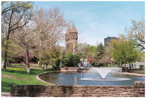
Source: Fitzgerald & Halliday, Inc., 2011
Figure 4-14 - Aerial view of Bushnell Park (with rail line on the left)
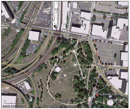
Source: Googlearth, 2011
Impacts
No-Build Alternative
The No-Build Alternative would continue existing service to existing stations. As a result, there would be no impacts to the Section 6(f) resources.
Proposed Project
The existing NHHS rail is immediately adjacent to the west of Bushnell Park for approximately 800 feet. There will be no direct or indirect impact to the park as a result of the proposed project.
Mitigation
Since there would be no impacts to the Section 6(f) resources, no mitigation is anticipated.
4.4.10 Transportation
Summary
Railroad: The proposed project would provide a beneficial impact to transportation by providing sufficient additional capacity on the NHHS rail corridor to support the level of passenger and freight rail service envisioned for without significant impact to operating performance.
Traffic: There are two intersections where the LOS falls below the criteria for acceptable LOS and causes adverse impacts primarily due to increased traffic at station access or intersections near a station. There are nine intersections where the LOS falls below the criteria for acceptable LOS and causes adverse impacts at intersections near grade crossings primarily due to increased train traffic. These impacts would be mitigated through roadway and signal improvements, as detailed in this section.
Parking & Transit: Parking at existing stations is not adequate to support the projected ridership for 2030. Parking would be increased to meet projected levels, along with additional bus bays/stalls at stations to support local bus access. Two additional bus bays/stalls would be added at the Windsor Locks station to support an express shuttle to Bradley International Airport. Bus stalls for private services at the current rail stations would be maintained. Access to transfer to the New Britain-Hartford Busway would be integrated into the station designs at Newington and West Hartford.
Pedestrian and ADA Access: The stations would provide ADA accessibility to trains and services. High-level platforms, connected by an aerial pedestrian overpass with stairs and an elevator, would provide safe access to trains, the station, and parking.
Applicable Law
NPA requires Federal agencies to examine the impacts of Federal actions on transportation. There are no direct additional applicable laws pertaining to railroad operation capacity analysis. FRA's "Railroad Corridor Transportation Plans; A Guidance Manual" was followed to assess railroad operating impacts. There also are no direct applicable laws pertaining to traffic operation capacity analysis. CTDOT studied and projected the design year traffic volumes for select intersections in the vicinity of the stations. Vehicular intersections would not be impacted in Massachusetts. At the federal level, laws relating to pedestrian access routes and parking spaces for persons with disabilities (quantity and configuration) include the Americans with Disabilities Act of 1990, as amended, and associated regulations and guidance.
Railroad Operations Methodology
A detailed NHHS operations model and Train Performance Calculator (TPC) simulation was performed to determine the projected performance of the future freight and passenger service as compared to the existing service. The following cases were evaluated:
- Existing No-Build condition (no change in existing track configuration and existing service);
- Future No-Build condition (no change in existing track configuration and existing passenger service, growth in freight service); and
- Build condition base on projected growth in freight service and the C-1 2020 Service Development Plan - Conceptual Working Schedule, This is included as Appendix 2 with freight and passenger schedules adjusted as described in the Service Development Plan.
A description of the modeling assumptions and the details of the findings are included in the Service Development Plan included as a reference document. The operation simulations are limited to the NHHS Corridor between New Haven and Springfield Terminal. Figure 4-15 illustrates the Railroad Operations Simulation Corridor and its relation to the entire New England Vision for High Speed and Intercity Passenger Rail. All of the connecting lines affecting the operation on the NHHS corridor are included in the model as boundary conditions.
These connecting rail lines include:
- Knowledge Corridor north of Springfield
- Northeast Corridor Shore Line East
- Northeast Corridor south of New Haven
All of the passenger and freight railroad operators operating on the NHHS Corridor and the boundary conditions are included in the simulation.
Summary of Existing Railroad Conditions
- Infrastructure - The NHHS Corridor is about 62 miles from New Haven, CT to Springfield, MA. The existing track configuration is illustrated in Figure 4-16 and consists of slightly greater than 24 miles of double track. The existing condition was used for the No-Build modeling.
- Freight Service - The freight operators (Connecticut Southern, Pan Am, Providence & Worcester, and CSX) serve a variety of daily shippers on the line. They maintain specific schedules to meet their customers' delivery and pick-up requirements and to interface with other rail operations on connecting routes. The freight operators provide about nine trips per day in the corridor. Their detailed schedules are included in the Service Development Plan; it varies based on the day of the week and the needs of their customers.
- Passenger Service - Amtrak operates generally six daily weekday round trip trains between New Haven, CT and Springfield, MA, which includes one daily round trip between Washington, DC and St. Albans, VT on the NHHS Corridor. Weekend service includes 8-9 round trip trains. About 36 daily round trip Amtrak and Metro North and Shore Line East trains operate on the NHHS Corridor for the short distance between New Haven and Mill River. The detailed schedules are included in the Service Development Plan.
Figure 4-15 - Railroad Operations Simulation Corridor

Figure 4-16 - No-Build Track Configuration
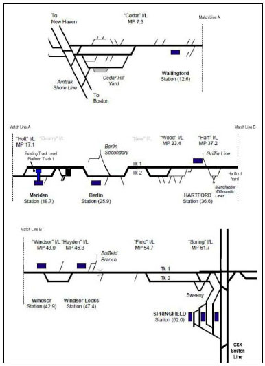
Direct and Indirect Railroad Impacts
- No-Build - Under this alternative no discretionary improvements in infrastructure would be made. The freight service tonnage and consists would continue to grow at a historic annual rate of 1.5% to 2% (1.75% average) compounded annually. Passenger service would remain at its current frequency and travel times.
Due to the growth in freight volume, delays to both passenger and freight trains would increase slightly in the future No-Build in the planning horizon year 2030 compared to current performance. Those delays are identified in Tables 4-25 through 4-27. - Build - Under this alternative the infrastructure would be improved through construction of the project as illustrated in Appendix 6. A track configuration of the Build configuration was developed by Amtrak, the freight railroads; Vermont, Massachusetts, and the FRA to accommodate the level of service envisioned for 2030, reflected in the C-1 2020 Service Development Plan - Conceptual Working Schedule, included as Appendix 2. The improvements include restoration of double track in single track areas, new sidings, additional/upgraded interlockings and cross-overs located across the corridor to facilitate track changes at locations where conflicts are likely to occur, and including using a gauntlet track at stations to facilitate wide freight loads. It does not include double-tracking of the Hartford Viaduct or of the Connecticut River Bridge at Windsor Locks. It should be noted that the track configuration may change slightly over time as design advances, freight and passenger train schedules change, and additional service is phased in. FRA requires all ROW users to agree to any changes in the corridor track configuration.
Under the Build alternative, freight service tonnage and consists would be allowed to grow at 1.5% to 2% (1.75% average) compounded annually. Passenger train speed limits would be increased to a maximum of 110 mph at selected locations. The TPC illustrating the proposed speed limits through the corridor is included in the Service Development Plan. Passenger service would be in accordance with and adjusted slightly as described in the Service Development Plan. The C-1 2020 schedule represents an increase in the number of passenger trains from the current 12 one-way trips in the corridor to 55 one-way trips.
FRA has established a goal that on-time performance (OTP) for passenger and freight service should achieve a 90% minimum without significant increase in delay compared to the Future No Build. Also, the Passenger Rail Investment and Improvement Act (PRIIA) of 2008 mandates that Amtrak OTP be at least 80%. The OTP results from the simulation runs on Case 1 (Existing No Build), Case 2 (Future No Build), and Case 4 (Build) are shown in Table 4-25 to Table 4-27.
Future operations would be acceptable when the Case 4 Build has delays that are comparable to the Case 2 Future No-Build. The simulation results compare the Future No-Build with the Build scenarios and future operations would be acceptable when the Case 4 Build has delays that are comparable to the Case 2 Future No-Build. The simulation results compare the Future No-Build with the Build scenarios and demonstrate that with the proposed infrastructure improvements the proposed passenger service OTP values are well within the 90% goal set by FRA and well above the mandated 80% level established by PRIIA.
| Case Number | Operating Case Name | Delay Percentage | |
|---|---|---|---|
| Passenger | Freight | ||
| 1 | Existing NO-BUILD | 1.4 | 14.2 |
| 2 | Future NO-BUILD | 1.5 | 14.9 |
| 4 | Build | 3.3 | 17.4 |
Table 4-26- Minutes of Delay per 100 Train-Miles
| Case Number | Operating Case Name | Minutes of Delay per 100 Train-Miles | |
|---|---|---|---|
| Passenger | Freight | ||
| 1 | Existing NO-BUILD | 2.0 | 39.5 |
| 2 | Future NO-BUILD | 2.2 | 42.2 |
| 4 | Build | 4.0 | 49.9 |
Table 4-27 - On Time Performance
| Case Number | Operating Case Name | On Time Performance | |
|---|---|---|---|
| Passenger | Freight | ||
| 1 | Existing NO-BUILD | 99.8% | 99.4% |
| 2 | Future NO-BUILD | 99.8% | 99.4% |
| 4 | Build | 95.2% | 96.7% |
Railroad Mitigation
The simulated delays are minor. During final design, the schedules for the future passenger and freight service would be optimized and an overall robustness study of the operating infrastructure completed for the corridor to validate infrastructure location.
Traffic Analysis Methodology
Traffic impacts at local streets near stations as well as selected road/rail at-grade crossings were analyzed and the results reported in two technical papers that are available for reference ("Traffic Operations Analysis" and "Windsor Locks Traffic Analysis"). These analyses were used to determine the traffic impacts resulting from increased passenger service at stations and at the at-grade crossings.
The intersections and at-grade crossings studied were selected by CTDOT after consultation with the affected towns; the intersections are listed in Table 4-28 and the at-grade crossings studied are listed in Table 4-29. (No applicable intersections or grade crossings occur in MA). A comprehensive list of at grade crossings in the project are included in Section 4.4.13 Safety and Security.
Table 4-28 - Study Driveways and Intersections
| Station Location | Intersection | Traffic Control |
|---|---|---|
| New Haven Union Station | Union Avenue and Church Street | Signalized |
| Union Avenue and Garage Driveway | Un-signalized | |
| Union Avenue and Parking Lot Driveway/Columbus Avenue | Signalized | |
| New Haven State Street | State Street and Trumbull Street | Un-signalized |
| State Street and Court Street | Signalized | |
| State Street and Chapel Street | Signalized | |
| North Haven | Route 5 and Devine Street/Station Driveway | Signalized |
| Devine Street and Route 40 Westbound Ramps | Signalized | |
| Devine Street and Hartford Turnpike | Signalized | |
| Dixwell Avenue and Hartford Turnpike | Signalized | |
| Dixwell Avenue and Route 40 Eastbound Ramps | Signalized | |
| Dixwell Avenue/Stiles Lane and Route 5 | Signalized | |
| Wallingford | North Colony Street and Route 150/Quinnipiac Avenue/Hall Avenue | Signalized |
| Washington Street/Hall Avenue | Signalized | |
| Washington Street/Quinnipiac Avenue | Signalized | |
| Route 150 and North Cherry Street/Hall Avenue | Signalized | |
| N. Cherry Street and Quinnipiac Avenue | Signalized | |
| North Colony Street and Parker Street | Signalized | |
| North Colony Street and Ward Street | Signalized | |
| Ward Street and S. Cherry Street | Signalized | |
| N. Cherry Street and Parker Street | Un-signalized | |
| Washington Street and Parker Street | Un-signalized | |
| Meriden | West Main Street and Colony Street | Signalized |
| East Main Street and State Street | Signalized | |
| East Main Street and Pratt Street | Signalized | |
| Hanover Street and S. Colony Street | Signalized | |
| Cook Avenue (Route 71) and Cooper Avenue | Signalized | |
| Pratt Street and Crown Street | Signalized | |
| S. Colony Street/Pratt Street | Signalized | |
| State Street/Cross Street | Un-signalized | |
| S. Colony Street/Cooper Avenue/Grant Street | Un-signalized | |
| Berlin | Route 372 and Main Street | Signalized |
| Route 372 and Depot Road (Station access) | Signalized | |
| Route 372 and Burnham Street/Porters Pass | Signalized | |
| Newington | Route 173 and Francis Avenue (Station access) | Un-signalized |
| Francis Avenue and Main Street | Un-signalized | |
| Main Street and Day Street/Brace Road | Un-signalized | |
| West Hartford | Flatbush Avenue and New Park Avenue | Signalized |
| Flatbush Avenue and Newfield Avenue | Signalized | |
| Flatbush Avenue and I-84 Ramps/Plaza Drive | Signalized | |
| New Britain Avenue and Newfield Avenue | Signalized | |
| New Britain Avenue and Grant Street | Signalized | |
| Newfield Avenue and Station Drive | Un-signalized | |
| Hartford | Asylum Avenue and I-84 Ramps/Spruce Street (Station access) | Signalized |
| Asylum Avenue and Garden Street/Farmington Avenue/I-84 Ramps | Signalized | |
| Spruce Street and Myrtle Street/Church Street | Signalized | |
| Windsor | Route 159 and Union Street | Un-signalized |
| Route 159 and Route 75/Broad Street | Signalized | |
| Route 159 and Maple Avenue | Signalized | |
| Route 159 and Batchelder Road | Signalized | |
| Batchelder Road and Mechanic Street | Un-signalized | |
| Broad Street and Central Street (Station access) | Un-signalized | |
| Windsor Locks | Route 159 and Lawnacre Road | Un-signalized |
| Route 159 and Stanton Road/Station Driveway | Un-signalized | |
| Route 159 and I-91 Southbound Ramps | Signalized | |
| Lawnacre Road and I-91 Northbound Ramps | Signalized | |
| Main Street and Church Street/Bridge Street | Signalized | |
| Main Street and Spring Street | Signalized | |
| Bridge Street and North Water Street | Signalized | |
| Enfield | N. River Street and North Main Street | Un-signalized |
| North Main Street and Station Driveway | Un-signalized | |
| North Main Street and Pearl Street | Un-signalized | |
| North Main Street/Elm Street and Route 5 | Signalized | |
| Pearl Street and Franklin Street/Route 190 On Ramp | Un-signalized | |
| Pearl Street and Frew Terrace/Route 190 Off Ramp | Un-signalized |
Table 4-29 - At-Grade Crossings Studied
| Town | Crossing | Mile post |
|---|---|---|
| North Haven | Sackett Point Road | 5.9 |
| Wallingford | Toelles Road | 10.5 |
| Ward Street | 12.3 | |
| Quinnipiac Street | 12.6 | |
| Hall Avenue | 12.65 | |
| Parker Street | 13.0 | |
| North Plains Highway | 13.6 | |
| Pent Highway | 14.4 | |
| Meriden | Cooper Street | 18.2 |
| South Colony | 18.5 | |
| East Main Street | 18.6 | |
| Cross Street | 18.8 | |
| Britannia Street | 19.4 | |
| North Colony Street | 19.4 | |
| West Hartford | Oakwood Avenue | 33.5 |
| Hartford | Hamilton Street | 34.9 |
| Central Street | 42.9 | |
| Windsor Locks | Bridge St. (S.R. 140) | 48.4 |
Traffic counts at station driveways and adjacent study road intersections were undertaken by the consultant team. The volumes were checked and balanced by CTDOT, which then provided the existing AM and PM peak hour volumes required for the traffic analysis.
Future traffic volumes were also developed by CTDOT using its statewide Travel Demand Model. The future traffic numbers were based on background traffic growth as determined by the CTDOT model for the No-Build alternative. For the build alternatives, future volumes accounted for trips generated by new or increased activity at the commuter rail stations.
Synchro 7 and VISSIM traffic analysis software were used to analyze the traffic capacity of intersections and station driveways. This program utilizes the analytical methodologies developed in the Highway Capacity Manual (HCM) and generates an intersection level of service output based on calculated delays and queues.
Level of Service (LOS)
Level of service (LOS) is a qualitative measure describing driver satisfaction with a number of factors that influence the degree of traffic congestion. These factors include speed and travel time, traffic interruption, freedom of maneuverability, safety, driving comfort and convenience, and delay. There are six levels of service describing flow conditions as follows:
- LOS A, describes a condition of free flow.
- LOS B represents a stable traffic flow with speeds beginning to be restricted.
- LOS C describes a stable condition of traffic operation.
- LOS D reflects a condition of more restrictive movements for motorists.
- LOS E involves delay to all motorists due to congestion.
- LOS F complete congestion occurs.
LOS D is considered acceptable for traffic operations in an urban environment.
Figure 4-17 graphically illustrates the traffic conditions experienced under the different Levels of Service at an intersection.
Figure 4-17 - Illustration of Level of Service Definitions
Figure 4-17 - Illustration of Level of Service Definitions (Continued)
Criteria for acceptable level of service (LOS):
- Intersections serving station driveways - If the level of service on any approach at this intersection shows LOS E or worse, mitigation to improve approach levels of service to LOS D or better would be required.
- Intersections not serving station driveways (off-site intersections) or not near at-grade crossings - This falls under two categories:
- If the project causes any approach to deteriorate in level of service (LOS E or worse), mitigation to improve approach levels of service to LOS D or better would be required.
- If the project maintains the same level of service (LOS E or worse) on any approach, mitigation would not be required.
Summary of Existing Traffic Conditions
The existing Levels of Service at the intersections studied are detailed in the referenced traffic analysis documents. All intersections operate at a level of service of D or better except the following:
- New Haven; Trumbull St. @ State St. WB approach, left turn; LOS E
- New Haven; Court St. @ State St. WB approach; LOS E
- Wallingford; North Cherry St. @ Hall Ave. SB approach; LOS E
- Meriden; Pratt St. @ E. Main St. SB approach; LOS E
- Newington; Francis Ave. @ Rt. 173 WB approach; LOS F
- Newington; Day St. @ Main St. EB approach; LOS E
- West Hartford; Flatbush Ave @ I-84 Ramps WB approach; LOS E
- West Hartford; Newfield Ave @ New Britain Ave SB approach; LOS F
All at-grade crossings operate at a level of service of D or better except the following:
- Hartford; Hamilton St. @ New Park Ave. WB approach; LOS F
- Hartford; Hamilton St. @ Bartholomew Ave. WB approach; LOS E
- Windsor Locks; Church/Bridge St.@ Main St EB approach; LOS E
Direct and Indirect Traffic Impacts
No-Build
Under this alternative there would be no new stations and no increase in automobile traffic accessing stations. Any reduction in LOS at station access drives and intersections near the stations would be due to increased in future traffic volumes not related to the proposed project. Similarly, there would be no increase in train frequency to cause increased congestion at the at grade crossings. Therefore, there would be no reduction in LOS at grade crossings. No adverse impacts would be caused by the No-build alternative.
Build Alternative
- Traffic Volume Impacts Near Proposed Stations - Intersections immediately adjacent to the stations would experience minimal increases in traffic as a result of increased patronage at the stations and the increased number of trains passing over the at-grade crossings. Based on the Traffic Operations Analysis of the intersections studied in the corridor, approximately 15% of the intersections near stations would experience a reduced LOS in the design year. The locations which experience a reduction in LOS falling below the criteria for acceptable LOS and causing adverse impacts primarily due to an increase in traffic volumes are :
- Route 173/Francis Avenue/Station Access (Newington)
- Asylum Avenue/Spruce Street/Station Access (Hartford)
- The main highways in the region would experience a reduction of 93 Million Vehicle Miles Traveled (VMT) as a result of project implementation, which is an overall project benefit.
- Grade Crossing Impacts And Mitigation Near Proposed Stations - There are three communities along the corridor where one or more at-grade crossings occur within close proximity to the proposed stations and would be impacted when a train stops at the station - Wallingford, Meriden, and Windsor Locks.
Intersections located near at-grade crossings in the vicinity of proposed stations in Wallingford and Windsor Locks would experience congestion and reduction in LOS due to the combination of the increased frequency of rail service and minor increases in overall traffic volumes. The following is a list of locations which experience a reduction in LOS falling below the criteria for acceptable LOS and causing adverse impacts primarily due to an increase in rail service:
- Wallingford
- Route 150/Hall Avenue/N. Cherry Street
- Quinnipiac Avenue/N. Cherry St.
- Quinnipiac Avenue/Hall Avenue/ North Colony Street /Center Street
- Route 150/Hall Avenue/Washington Street
- North Colony Street /Parker Street
- North Colony Street /Ward Street
- Windsor Locks
- Route 140/Bridge Street/Route 159/Church Street
- Main Street and Spring Street
- Main Street and Church Street/Bridge Street
Intersections adjacent to the Meriden station will not deteriorate in LOS due to grade crossings compared to the no-build conditions and there are no adverse impacts.
- Grade Crossing Impacts (Not Adjacent To Station Areas) - Intersections immediately adjacent to at-grade crossings throughout the corridor would experience minimal increases in traffic. The traffic impact due to more frequent rail service would result in a slight increase in delay but no reduction in LOS and no adverse traffic impact.
Traffic Mitigation
To mitigate the adverse traffic impacts at the affected station access driveways and intersections near the stations, the following would be implemented:
- Route 173/Francis Avenue/Station access (Newington) - Install new traffic signal.
- Asylum Avenue/Spruce Street/Station Access (Hartford) - Re-striping of approach roadways and signal timing improvements.
To mitigate the adverse traffic impacts at the affected grade crossings the following would be implemented:
- Route 150/Hall Avenue/N. Cherry Street (Wallingford) - Signal timing changes.
- Quinnipiac Avenue/N. Cherry St. (Wallingford) - Signal timing and phasing changes in railroad pre-emption operation. Allow N. Cherry Street movements during the railroad pre-emption phase.
- Quinnipiac Avenue/Hall Avenue/North Colony Street/Center Street (Wallingford) - Signal timing and phasing changes in railroad pre-emption operation. Allow northbound left turn movements on North Colony Street during the railroad pre-emption phase.
- Route 150/Hall Avenue/Washington Street (Wallingford) - Signal timing changes.
- North Colony Street /Parker Street (Wallingford) - Signal timing changes.
- North Colony Street /Ward Street (Wallingford) - Signal timing changes.
- Route 140/Bridge Street/Route 159/Church Street (Windsor Locks) - Turn restrictions and signal phasing/timing changes.
- Main Street and Spring Street (Windsor Locks) -Signal phasing/timing changes.
- Main Street and Church Street/Bridge Street (Windsor Locks)
- Prohibit eastbound Church Street through and left-turn movements and reallocate signal green time to southbound Main Street and westbound Bridge Street. Right turns would still be allowed from Church Street.
- Remove the traffic signal at the driveways to the Montgomery and Ahlstrom properties and reallocate green time to Main and Bridge streets. Montgomery and Ahlstrom driveway movements would be restricted to right-turn in and right-turn out operations only. Left-turns into and out of the Montgomery and Ahlstrom driveways would be prohibited.
- Install a median barrier on Bridge Street at the Montgomery and Ahlstrom driveways to physical prevent left-turn movements into and out of the driveways.
- Modify the signal timing to allow the westbound Bridge Street right turn to receive green time concurrently with the protected southbound Main Street left-turn green phase.
- Modify the signal timing to allow the northbound Main Street right turn to receive green time concurrently with the protected westbound Bridge Street left-turn green phase.
The proposed signal timing and railroad pre-emption changes in Wallingford would mitigate the reduction in LOS and reduce the congestion to a level occurring under the Build alternative to comparable or better than the under no-build condition. These improvements would be further coordinated with the Town of Wallingford and developed during final design.
The Bridge Street grade crossing near the proposed downtown Windsor Locks station (Sheet 41 Windsor Locks Conceptual Plan 2, included in Section 1.3 of Volume II of this EA/EIE) would experience a reduction in LOS. The proposed mitigation would eliminate the signals and add a median barrier on Bridge Street that would not allow left turns into or out of private property on Bridge Street. The project would also provide intersection improvements at Bridge Street and North Street in East Windsor to accommodate the desired traffic movements and access to various destinations.
Transit, Parking, and Pedestrian Access
Methodology
- Transit - Transit schedules and routes for Connecticut Transit service to existing and proposed rail stations were studied to compare the arrival and departure of the trains and transit. This study was reported in a separate technical paper available as a reference document ("Transportation/ Transit"). The results of this report were used to determine transit route extensions, added transit trips, and the number of transit stalls necessary to integrate local transit with the rail passenger service.
- Parking-The travel demand models completed by CTDOT and Amtrak were used to determine the number of passenger boardings and modal splits at each station. This study was reported in a separate technical paper available as a reference document ("Data Collection/Ridership Analysis"). The results of this report were used to determine the number of riders arriving by automobile and, in turn, the number of parking spaces needed for kiss-n-ride and all day parking.
- Pedestrian Access - The travel demand models completed by CTDOT indicated that some passengers would walk to the station. While these volumes are low, it demonstrates that safe pedestrian access must be provided from the local sidewalks to the station platforms.
Summary of Existing Conditions
All of the existing railroad stations provide for bus access, some parking, and pedestrian access. The urban stations at New Haven, Hartford, and Springfield have parking facilities operated by the local parking authority, which charge for parking. For the remaining stations, limited free parking is available. The New Haven stations have high-level platforms providing "level boarding" from the platform into the trains. All other stations have low level boarding platforms, requiring passengers to climb stairs into the trains or use a manually operated lift for access of wheelchairs. At Meriden Station, there are two tracks at the station, requiring passengers to cross the active track to access the train. This increases boarding time and can cause delays to other trains operating in the vicinity.
Direct and Indirect Impacts
- No-Build Alternative - Under this alternative there would not be any new stations or enhancements to existing stations, nor any passenger rail related increase in transit, automobile, or pedestrian traffic accessing stations. Therefore, there would be no increase in the number of bus bays/stalls or automobile parking requirements. No adverse impacts would be caused by the No-build alternative.
Build Alternative:
- Transit - The increase in train service would increase the number of passengers arriving and departing at each station and, in turn, increase the need for timed connectivity with local transit, as well as with commuter and Amtrak trains at New Haven connecting to points south/west and north/east. In addition, a shuttle bus connection at the Windsor Locks Station would provide access for train passengers to Bradley International Airport. Stations at Newington and West Hartford would provide cross-platform access to the recently approved New Britain-Hartford Busway.
- Parking - The current number of parking accommodations at the existing stations are below the planned parking capacity (Table 4-30) needed to support the projected intercity and commuter ridership as well as the current non-rail parking (some of the lots also serve as carpool park and ride). Without additional parking accommodations at the stations, auto arrivals, ridership, and local area traffic congestion will be adversely impacted.
Table 4-30 - Planned Parking Capacity
| Station | Existing Total Parking Spaces | Planned Total Parking Spaces |
Kiss and Ride Spaces Included |
|---|---|---|---|
| New Haven Union (1) | NA | 249 | 15 |
| New Haven State Street (1) | NA | 127 | 5 |
| North Haven | 65 | 288 | 7 |
| Wallingford | 0 | 210 | 9 |
| Meriden | 0 | 300 | 11 |
| Berlin | 60 | 232 | 9 |
| Newington | NA | 202 | 5 |
| West Hartford | NA | 167 | 3 |
| Hartford Union (1) | NA | 342 | 18 |
| Windsor | 116 | 180 | 4 |
| Windsor Locks | 20 | 107 | 3 |
| Enfield | 71 | 214 | 6 |
| Springfield Union (1) | NA | 364 | 21 |
Note 1: The project would not be constructing additional parking capacity at New Haven Union Station, New Haven State Street Station, Hartford Union Station, or Springfield Union Station. Parking needs at those stations are provided by and will be addressed and advanced by the local parking authorities to be compatible with their downtown development plans. The parking capacity added by the local parking authorities may be phased over several years to meet the parking demand as it develops.
- Pedestrian and ADA Access- Increased volumes of passengers boarding or disembarking trains at stations will cause significant delays if passengers are required to use stairs or if a lift is required for wheelchair or other disability access. There is currently limited access across the tracks to the opposite platform. The project includes high-level platforms at all existing and future stations (except at Springfield, where the city and Massachusetts are implementing a separate project to improvement the station platforms). The platforms would be connected by an aerial pedestrian overpass for safe access between platforms. These would provide both stairs and elevator access.
Mitigation:
- Transit: Increased connections to and from local bus transit would be facilitated by providing two to four bus stalls at each rail station, with two additional stalls at the Windsor Locks station to provide an express shuttle to Bradley International Airport. Bus stalls for private services at the current rail stations will be maintained. Access to the New Britain - Hartford Busway buses would be integrated into the station designs at Newington and West Hartford.
- Parking - Increase station parking capacity as indicated in Table 4-30 at all stations except New Haven Union, New Haven State Street, Hartford Union, and Springfield Union. At these stations parking would continue to be provided by the local parking authority.
- Pedestrian and ADA Access-- All stations that are reconstructed, relocated, or new would provide ADA accessible routes from the existing sidewalks at the edge of the project limits to the boarding platforms. The ADA accommodations would include curb ramps, longitudinal and cross slopes that meet ADA requirements, ramps to the platforms, ADA parking spaces, and pedestrian bridges with elevator access to cross over the tracks. Similarly, the sites would be designed to include access by bicycle on the station drives and bicycle storage. High-level platforms, connected by an aerial pedestrian overpass, would provide safe access to the platforms and the trains. The New Haven Union Station already meets ADA requirements and is not being improved as part of this project. Springfield Union Station does not have high level platforms; accessibility improvements to this station would be part of a future project.
4.4.1 Public Utilities and Energy
Summary
The proposed project may require utility relocations during project construction, which would be coordinated with utility providers to optimize relocation work during the program. Potential disruption to utility customers would also be minimized through coordination with utility providers.
The proposed project would have a positive impact on energy requirements as increased regional rail ridership would result in a reduction in personal automobile usage and reduced fossil fuel consumption.
Applicable Law
Relocation of local utilities located in the railroad ROW would comply with all applicable federal and state laws. Relocations would include water, sewage and other pipe crossings, electrical and natural gas lines, communications cables, and utilities required to support rail operations such as at-grade crossing equipment.
While there are no laws pertaining to energy requirements for the rail project, the proposed transportation improvements are consistent with federal and state initiatives to reduce energy consumption.
Methodology
Locations of existing utilities that could be affected by the proposed project were determined through review of available survey-based mapping, site visits and discussions with utility companies and Amtrak. Plans and as-built drawings have been collected, where available.
Travel demand forecasts for the analysis year (2030) without and with the proposed project were obtained from CTDOT and Amtrak as the basis for estimating the potential reduction in vehicle miles traveled (VMT) and the associated change in fuel consumption.
Existing Conditions
Utilities in the NHHS rail corridor ROW that could be affected by double-track restoration, installation and at-grade crossing improvements and other work include water, sewage and other pipe crossings, electrical and natural gas lines, communications cables and utilities required to support rail operations such as at-grade crossing equipment and interlockings. Utility providers include, but are not limited to, Northeast Utilities, local and regional water companies (Metropolitan District Commission, South Central Connecticut Regional, City of Berlin, City of Meriden, and City of New Britain), Level 3 Communications, Connecticut Natural Gas, AT&T, Comcast, and CoxCom. The North Haven, Newington, and Hartford regional rail stations have overhead utilities along the railroad tracks.
Impacts
No-Build Alternative
The No-Build Alternative, with the current rail and transit service and no physical alterations in the NHHS rail corridor, would not result in any utility impacts.
Build Alternative
Construction of the proposed project would require utility relocations. For example, overhead utilities at the Newington and North Haven stations may have to be raised to clear the proposed pedestrian crossover. Level 3 fiber optic cables running within and along the NHHS rail corridor would have to be replaced. In addition, Amtrak intends to install new power, signal, and communications cables along the west side of the corridor. CTDOT has met with utility owners along the corridor to advise them of the project and to seek as-built and other design plans to help identify the location of utility crossings and their depth. As design of the improvements advance, CTDOT would work with the utility owners to optimize the scheduling of utility relocations.
Based on the preliminary Passenger Service Plan, the proposed project would result in a total reduction of 92.65 million miles in VMT of light-duty vehicles and an increase of 760,000 gallons of diesel fuel used for train locomotion. Overall energy consumption would be reduced (Table 4-31) with increased regional rail ridership, particularly during peak hours of travel. The resulting reduction in regional consumption of fossil fuels would reduce greenhouse gas emissions.
Table 4-31- Energy Requirements
| Change in Fuel Consumption in Design Year (2030) | |||||
|---|---|---|---|---|---|
| Reduction in MVT |
Fuel Quantity (Gal) |
Fuel Type | Energy Content (BTU/Gallon)2 | Energy Consumption (1,000,000,000 BTU's) | |
| Light Duty Vehicles | -92,650,000 | 3,369,0901 | Gasoline | 120,215 | -405 |
| Locomotive | N/A | 760,000 | Diesel | 132,915 | 101 |
| Net Reduction in Energy Consumption | -304 | ||||
Source: CDM Smith, 2011
1: Fuel quantity is based on an average consumption of 27.5 miles per gallon. (National Highway Traffic Safety Administration 2010 CAFE Standards)
2: US Department of Energy, Alternative Fuels and Advanced Vehicles Data Center (AFDC) 2011, Average of Lower and Higher BTU Values.
Mitigation
Utility service disruptions during construction would be minimized through close coordination of construction activities, scheduling with utility providers and advanced notice of any anticipated outages to nearby customers. Project engineers would coordinate with utility providers to minimize environmental and community impacts to the greatest extent practicable.
4.4.12 Hazardous Materials and Environmental Risk Sites
Applicable Law
Federal agencies are required to consider the impact of Federal actions on hazardous material sites. There are no additional governing State statutes that are applicable to the preparation of this section of the EA/EIE. CT DEEP and MassDEP environmental compliance laws would be applicable during project final design and construction.
Methodology
Hazardous waste sites were identified using the EPA's 2002 Comprehensive Environmental Response, Compensation, and Liability Information System (CERCLIS) GIS coverage for those towns located in the New Haven-Hartford-Springfield Rail Corridor in Connecticut and Massachusetts. In addition, the CT DEEP GIS coverage, Landfill Leachate and Wastewater Discharges, and MassGIS (MassDEP) were used to augment the CERCLIS information obtained for the study corridor. Those CERCLIS or other potential hazardous materials sites located within 250 feet of the rail corridor were identified on project mapping (included as Section 2.6 of Volume II of this EA/EIE). No field verification or visual inspection of these locations was conducted.
Existing Conditions
Along the existing railroad track bed, there is a high probability of the presence of contaminated soils or debris. Contaminants commonly found associated with railroad corridors include railroad ties (wood treating chemicals), spilled, or leaked fluids (oil, cleaning solvents), herbicides, transformer fluids [Polychlorinated biphenyl (PCBs)], fossil fuel combustion products [Polycyclic aromatic hydrocarbons (PAHs)], asbestos, and metals such as arsenic and mercury. Also, existing steel bridge overpasses along the corridor were likely painted with lead-based paint prior to 1970, which may or may not have been removed or sealed.
Based on GIS analysis, the rail corridor contains 19 CERCLIS-listed sites. In addition, 44 other potential hazardous waste sites were identified on the CT DEEP Landfill Leachate and Wastewater Discharges data layer. All hazardous waste sites located within the New Haven-Hartford-Springfield Rail Corridor are presented below in Table 4-32 and are collectively called environmental risk sties - locations where hazardous materials are known to have been used and/or hazardous waste generated and potentially discharged to the ground or water. Additional information regarding the location of these sites in relation to the rail corridor as well as Hazardous Materials and Leachate Waste maps can be found in Section 2.6 of Volume II of this EA/EIE.
Table 4-32 -Hazardous Materials Risk Sites within 250 Feet of the Rail Corridor
Study Area City/Town |
Number of Sites | Site Type |
|---|---|---|
| New Haven | 1 | CERCLIS |
| 1 | Combined Sewer Overflow | |
| Hamden | 1 | CERCLIS |
| 1 | Oil Spill | |
| 1 | Sludge Lagoon | |
| North Haven | 2 | Cooling Water Discharge |
| 1 | Landfill for Tires | |
| 3 | Treated Industrial Discharge | |
| 2 | Bulky Waste Landfill | |
| Wallingford | 2 | CERCLIS |
| 1 | Salt Storage | |
| 3 | Automobile Junkyard | |
| 1 | Industrial Pit | |
| 1 | Sewage Treatment Plant | |
| Meriden | 1 | Industrial Pit |
| 1 | Treated Industrial Discharge | |
| Berlin | 1 | Chemical Spill |
| New Britain | 1 | Solid Waste Transfer Station |
| 1 | Industrial Wastewater Discharge | |
| Newington | 1 | CERCLIS |
| 3 | Industrial Wastewater Discharge | |
| 1 | Cooling Water Discharge | |
| 1 | Sewage Treatment Plant | |
| West Hartford | 3 | CERCLIS |
| 1 | Cooling Water Discharge | |
| 1 | Industrial Wastewater Discharge | |
| 1 | Ash Waste Landfill | |
| Hartford | 2 | Cooling Water Discharge |
| 2 | Automobile Junkyard | |
| 2 | Oil Spill | |
| Windsor | 2 | CERCLIS |
| 2 | Cooling Water Discharge | |
| 1 | Industrial Pit | |
| Windsor Locks | 1 | Bulky Waste Landfill |
| 1 | Industrial Wastewater Discharge | |
| 1 | Cooling Water Discharge | |
| Enfield | 3 | CERCLIS |
| 1 | Sewage Treatment Plant | |
| Longmeadow | 0 | n/a |
| Springfield | 6 | CERCLIS |
Impacts
Impacts from environmental risk sites and hazardous materials were evaluated based on proximity of the proposed project site(s) to the CERCLIS-listed and other potential hazardous risk sites. Those CERCLIS or other potential hazardous materials sites within 250 feet of the rail corridor were identified as potential risk/impact areas.
No-Build Alternative
The No-Build Alternative would constitute the continuation of existing rail service, which would not result in any anticipated changes to the existing railroad line or associated facilities. As such, the No-Build Alternative would not result in direct or indirect impacts to environmental risk sites or from hazardous materials.
Proposed Project
Impacts to environmental risk sites or from hazardous materials are not expected from the proposed project with the following exceptions:
- Along the existing railroad track bed, there is a high risk for encountering contaminated soils or debris during project construction. Any construction near the steel bridge structures is likely to encounter lead-containing soils and dust from the previous use of lead-based paint.
- Older building structures along the corridor requiring demolition would necessitate lead and asbestos testing and possible abatement.
- There is one potentially hazardous waste site located in the double tracking segment from MP 35.1 to MP 37.2. Further investigation into the property at 17-35 Bartholomew Avenue in Hartford (MP 35.21), which is listed as a brownfields site, would be conducted at the time of final design to determine the presence of oil and hazardous materials (OHMs).
- Along the existing railroad track bed and in the vicinity of the proposed Springfield Layover site at Armory Street there is a strong probability for encountering contamination during project construction. Contaminants commonly found associated with railroad corridors are listed above in the existing conditions section.
- There are no CERCLIS or other potentially hazardous waste sites in the vicinity of the existing and proposed station locations with the exception of the North Haven Station site; a proposed new station. This potential hazardous waste source consists of the industrial discharge from contaminated site located on the parcel located east of the tracks proposed for station parking. Construction of the proposed station in this location may have an adverse impact from movement, exposure or disturbance of OHMs.
Mitigation
The property at 17-35 Bartholomew Avenue in Hartford (MP 35.21), which is listed as a brownfields site, would be further investigated at the time of final design to determine the presence of OHMs. For identified potential Environmental Risk and Hazardous Materials Sites in Connecticut, State of Connecticut regulatory requirements would be followed by CTDOT through its environmental compliance process as the proposed project progresses through to final design and construction. In Massachusettes, the requirements of the Massachusettes Contingency Plan would be followed. If contaminated soils are discovered during track work, the following tasks would be required during the final design:
- Sample the soils to determine the nature and location of contaminated soil.
- Establish locations and techniques for storing excavated material on the site in a manner that contains run-off of contaminated material.
- Use or distribute as much excavated material as possible within the final ROW in a way that contains run-off of contaminated materials.
- Establish requirements for transporting and disposing of contaminated materials that cannot be used or distributed within the final ROW.
Impact Summary
Potential impacts to environmental risk sites include the following:
- Existing railroad track bed; there is a high risk for encountering contaminated soils or debris during project construction
- Older building structures along the corridor requiring demolition can contain lead and asbestos.
- The property at 17-35 Bartholomew Avenue in Hartford (MP 35.21), which is in the vicinity of the area of double tracking and is listed as a brownfields site, has a probability of the presence of OHMs.
- Along the existing railroad track bed and in the vicinity of the Springfield Layover site there is a strong probability for encountering contamination during project construction.
- There is a potential hazardous waste source on the site of the proposed North Haven Station consisting of treated industrial discharge from Humphrey Chemical.
These would be mitigated with:
- In-depth studies at the time of final design;
- Lead and asbestos testing and abatement;
- Adherence to state of Connecticut environmental compliance requirements; and
- Adherence to the requirements of the Massachusettes Contingency Plan.
4.4.13 Safety and Security
Summary
The proposed project would not appreciably impact public health, safety and security in the NHHS rail corridor. While greater frequency of trains may increase the frequency of opportunities for conflict between trains and vehicles or people, safety improvements at crossings and improved communications among emergency responders would be a beneficial impact, serving to minimize potential conflicts and their consequences. Safety and security design features at the stations would also have a beneficial impact. An increase in rail service is expected to divert some vehicular traffic to the rail mode in the region and, thus, would indirectly improve safety on roads and highways. Implementation of the proposed project would conform to all applicable safety requirements, regulations, standards and certifications and a comprehensive NHHS System Safety Program (SSP), as described below under "Mitigation," would be developed for the proposed project.
Applicable Law
NEPA requires Federal agencies to consider the impact of Federal actions on public safety.
Rail Safety Improvement Act of 2008 (Public Law 110-432)
The Rail Safety Improvement Act reauthorized funding to enable FRA to oversee the nation's rail safety program between 2009 and 2013. One aim of the statute is to improve conditions of rail bridges and tunnels. The Rail Safety Improvement Act also requires that railroads implement Positive Train Control (PTC) systems to prevent train-to-train collisions on certain rail lines by the end of 2015. PTC infrastructure is integrated command, control, communications, and information systems for controlling train movements that improve railroad safety by significantly reducing the probability of collisions between trains, casualties to roadway workers and damage to their equipment, and over-speed accidents.
Federal Railroad Administration (49 CFR Volume 4, Chapter II, Part 200 to 299)
FRA regulations for railroad transportation safety, including standards, rules, and practices, are listed in 49 CFR Parts 200 to 299.
U.S. Code on Railroad Safety (49 U.S.C. §§ 20101 et seq.)
Part A of Subtitle V of Title 49 of the United States Code (49 U.S.C. §§ 20101 et seq.) contains a series of statutory provisions affecting the safety of railroad operations. In particular, Section 20109 protects the reporting of safety concerns and injuries and prohibits railroads from disciplining, discharging, or retaliating in any form against employees who engage in protected activities. This section also prohibits the delay or interference of an injured employee's treatment.
Department of Homeland Security/Transportation Security Administration (49 CFR 1580)
Part 1580, Rail Transportation Security, codifies the Transportation Security Administration inspection program. It also includes security requirements for freight railroad carriers; intercity, commuter, and short-haul passenger train service providers; rail transit systems; and rail operations at certain fixed-site facilities that ship or receive specified hazardous materials by rail.
Transportation Security Administration - Security Directives for Passenger Rail Security
Directives RAILPAX-04-01 require rail transportation operators to implement 15 protective security measures, which include reporting potential threats and security concerns to the Transportation Security Administration, and designate a primary and alternate security coordinator.
Emergency Planning and Community Right-to-Know Act (42 CFR 116)
The objectives of the Emergency Planning and Community Right-to-Know Act are to allow state and local planning for chemical emergencies, provide for notification of emergency releases of chemicals, and address a community's right-to-know about toxic and hazardous chemicals.
Methodology
Facilities and services related to the provision and protection of safety and security in the NHHS rail corridor were identified through review of the 2005 New Haven-Hartford-Springfield Commuter Rail Implementation Study, data provided by municipal planning staff/offices, limited field review, and review of current aerials (2010) of the study corridor.
Existing Conditions
Protection of safety and security in the NHHS rail corridor is accomplished through the combined facilities and services of the rail companies (Amtrak, CSX, and others), local police departments in each town/city in the corridor, the Connecticut State Police and other local emergency service providers.
Amtrak, along with the freight rail companies currently operating on the NHHS rail line, assume responsibility for rail line safety and security. At-grade crossings and direct rail access at the existing stations have warning signals and gates. All trains sound their horns as they approach stations and travel through at-grade crossings. Existing controls at numerous street and highway crossing locations range from grade crossings equipped with active warning systems (gates and flashing light signals), crossings that provide active warning without gates, and crossings with only passive warnings.
Fencing exists along various areas of the railroad ROW. However, there is no discernible pattern to fencing locations and the fencing is in various states of condition.
There are 13 emergency service stations (police, fire, and ambulance) and three hospitals within the study corridor (see Table 4-33 and Community Facilities Maps in Section 2.1 of Volume II of this EA/EIE).
Table 4-33 - Emergency Services and Hospitals in the Study Corridor
| Town | No. of Emergency Services Stations |
No. of Hospitals |
|---|---|---|
| New Haven | 3 | 1 |
| Wallingford | 1 | 0 |
| Berlin | 1 | 0 |
| Newington | 2 | 1 |
| Hartford | 4 | 1 |
| Springfield | 2 | 0 |
| Total | 13 | 3 |
Impacts
No-Build Alternative
The No-Build Alternative would continue existing rail operations to existing stations with existing controls for public safety and security. There would be no direct or indirect impacts to safety and security with the No-Build Alternative.
Proposed Project
The proposed project would not appreciably impact safety and security because the NHHS rail line is currently active and operational with safety measures, such as crossing gates, in place. There would be a greater frequency of train movements, which may increase the frequency of opportunities for conflict between trains and vehicles or people. The proposed project's upgrade and replacement of at-grade crossing signal equipment and installation of supplemental safety devices, such as four-quadrant gates or non-mountable median dividers, would provide additional safety protection (see Table 4-34). This would have the beneficial impact of improving public safety at potential conflict points. If safety at crossings meets certain FRA risk thresholds, the communities within which the crossings are located would be able to seek designation of Quiet Zones at the crossings, eliminating the need for trains to sound their horns.
No impacts to safety and security would occur as a result of the proposed train layover and maintenance facility in the Springfield area. CTDOT is working with Amtrak to explore ways to improve communications between the towns and Amtrak dispatchers in order to expedite movement of emergency response vehicles for safety and security purposes at-grade rail crossings. This would result in a beneficial impact to safety and security.
The project includes addition of fencing at appropriate locations where there is a history or evidence of known trespassing and adjacent to public recreation areas and schools. A fencing inventory and condition analysis would be completed and a fencing policy established for the project. Fencing also would be provided at stations as required to prevent passengers from crossing tracks to access platforms.
Table 4-34 - Grade Crossings in NHHS Rail Corridor and Proposed Improvements
| LOCATION CITY/TOWN | CROSSING NAME | MILE POST | NUMBER OF TRACKS EXISTING/PROPOSED |
TYPE | PROPOSED ACTION |
COMMENTS |
|---|---|---|---|---|---|---|
| Windsor | East Barber Street | 40.16 | 1/2 | Public At Grade | Two Quadrant Gates | 100' and 70' non-mountable curb median dividers |
| Windsor | Island Road | 42.27 | 1/2 | Public At Grade | Two Quadrant Gates | Two - 100' non-mountable curb median dividers |
| Windsor | Central Street | 42.92 | 1/2 | Public At Grade | Four Quadrant Gates | Commerial driveways prohibit the installation of non-mountable curb median divider |
| Windsor | Pierson Lane | 43.68 | 2/2 | Public At Grade | Two Quadrant Gates | Two - 100' non-mountable curb median dividers |
| Windsor | Macktown Road | 45.05 | 2/2 | Public At Grade | Two Quadrant Gates | 100' and 70' non-mountable curb median dividers |
| Windsor | Hayden Station Road | 45.65 | 1/2 | Public At Grade | Four Quadrant Gates | Commercial driveway prohibits the installation of non-mountable curb median divider |
| Windsor Locks | T-2 Trolley Barn | 46.66 | 2/2 | Private At Grade | To Be Closed | Pedestrian crossing |
| Windor Locks | Dexters | 48.20 | 1/2 | Private At Grade | Two Quadrant Gates | Dexter Co - Pedestrian walkway gates across road; No automobile traffic except in emergency. No median divider proposed |
| Windor Locks | Montgomery Co. | 1/2 | Private At Grade | Pedestrian Gates | Pedestrian crossing | |
| Windor Locks | Bridge Street | 48.43 | 1/2 | Public At Grade | Four Quadrant Gates | Roadway prohibit the installation of non-mountable curb median divider |
| Enfield | Parsons Lane | 51.44 | 1/2 | Public At Grade | Two Quadrant Gates | Two - 100' non-mountable curb median dividers |
| Enfield | Bridge Lane | 52.38 | 1/2 | Public At Grade | Two Quadrant Gates | Right Turn in and Right Turn out configuration of two residential driveways within median divider shall be imposed. |
| Enfield | T-2 Saw Mill Xing | 55.66 | 1/2 | Private At Grade | To Be Closed | Gravel crossing surface. Crossing barricaded with welded steel barricade on East side only. Grade crossing will remain closed |
| Longmeadow, MA | Bark Haul Road | 56.70 | 1/2 | Public At Grade | To Be Closed | Possible closure of crossing or install passive signage |
| Longmeadow, MA | Birnie Road | 57.30 | 1/2 | Public At Grade | To Be Closed | Possible closure of crossing or install passive signage |
| Longmeadow, MA | Emerson Road | 58.14 | 1/2 | Public At Grade | Four Quadrant Gates | Commerial driveway and roadway prohibit the installation of non-mountable curb median divider |
| West Springfield, MA | West Union St | 61.03 | 1/2 | Private At Grade | To Be Closed | Crossing is closed and will remain closed |
| West Springfield, MA | State Street | 61.20 | 1/2 | Public At Grade | Two Pedestrian Gates | Gates for Pedestrian crossing only, no median divider proposed |
The designs for proposed station improvements would employ techniques that can enhance and create a sense of security for rail passengers, transit and personal vehicles accessing the station, pedestrians, and nearby residents and business while deterring potential undesirable or unsafe behavior. Examples of the techniques that would be used include: access control, surveillance, and lighting. Local law enforcement would be responsible for surveillance and security at the stations.
The increase in rail service is anticipated to displace some vehicular traffic from congested streets, which would indirectly improve safety on roads and highways within the communities located along the study corridor.
Mitigation
The NHHS Rail Program would conform to all applicable FRA, FTA, OSHA, Amtrak and state safety and security requirements, regulations, standards, and certifications. These measures would be incorporated into a comprehensive NHHS System Safety Program (SSP) that ensures the development and coordination of responsibilities for implementing key safety and security policies. Appropriate life safety plans and procedures, such as the Manual for Development of System Safety Program Plans for Commuter Railroads (APTA, 2006), would be incorporated into the administration, design and operations of the NHHS rail line to ensure the safety and security of the passengers, employees and the public. The SSP would address the broad categories of safety management administrative requirements, safety program implementation, safety engineering techniques and analysis, and safety assurance.
A fencing policy would be established to provide protection in areas of known trespassing and at recreation and school locations. Fencing would be included at stations to prevent passengers from crossing tracks to access trains.
4.4.14 Environmental Justice
Summary
The proposed NHHS rail corridor service enhancements would have a beneficial impact on environmental justice (EJ) populations in the vicinity of improved existing stations and relocated and proposed new stations. The proposed project would provide improved access to regional rail services with station locations nearer to some EJ populations, thereby improving mobility options for those who are transit-dependent. It is anticipated that EJ populations near New Haven Union, Meriden, West Hartford, Hartford, and Springfield Union stations would be most beneficially impacted.
Implementation of improvements to or relocations of existing regional rail stations, construction of the proposed new stations, and construction of the proposed Springfield Armory Site layover/maintenance facility would not adversely impact EJ populations near these facilities. These changes would not disproportionately impact neighborhood character, access to jobs, goods or services, or social interaction where EJ populations are located near each station. Certain intersections near EJ populations in Hartford and Wallingford would experience traffic conjestion due to increased train service and consequent additional automobile traffic. EJ populations in Wallingford, Meriden, Windsor and Enfield would experience additional noise due to the increased train service. These effects would be mitigated as described in Sections 4.2.2 (Noise) and 4.4.10 (Transportation/Traffic) of this EA/EIE.
Applicable Law
The USDOT has a policy to insure nondiscrimination under Title VI of the Civil Rights Act of 1964. The specifics of Title VI are that "no person in the United States shall, on the ground of race, color, or national origin be excluded from participation in, be denied the benefits of, or be subjected to discrimination under any program or activity receiving Federal financial assistance."
Additionally, Executive Order 12898, Federal Actions to Address Environmental Justice in Minority Populations and Low- Income Populations, issued in 1994, states that "each Federal agency shall make achieving environmental justice part of its mission by identifying and addressing, as appropriate, disproportionately high and adverse human health or environmental effects of its programs, policies, and activities on minority populations and low-income populations."
Methodology
Typically, U.S. Census Bureau (Census) data are used to determine the presence or concentration of minority and low-income populations in the census tracts and block groups located within a study area. However, because sufficiently detailed data are not yet available from the 2010 Census, the following approach was used to identify locations of EJ populations and reflect current population characteristics in the EJ analysis area:
- Obtained data from the 2009 American Community Survey (ACS); the ACS contains Census data that have been updated to 2009 via surveys (yielding sample data) and projections of post-2010 Census trends;
- Refined the study area to include all census tracts and block groups within a 1/2-mile radius of the NHHS rail line in all directions, which is both a walkable distance to/from the regional rail stations and consistent with the study areas defined for evaluation of potential impacts (noise and air) resulting from project-related rail operations;
- Collected data by block group for the entire study area;
- Identified all block groups that intersect with the study area (269 block groups collectively encompass the EJ study area);
- Calculated total population for the 269 block groups in the study area (321,995);
- Calculated the mean percent minority for the 269 block groups in the study area (46 percent), as well as for the study area as a whole (69 percent).
- Determined a threshold for a minority concentration: any block group with a minority population higher than the mean percent minority for the 269 block groups of 46 percent is considered to contain a minority concentration; block groups with minority percentage more than 50 percent higher than the study area mean (69 percent) indicates a high concentration for analysis purposes;
- Calculated the mean median household income for the 269 block groups in the study area ($50,480);
- Determined a threshold for a low-income concentration: any block group with an annual median household income lower than $50,480 is considered to have a concentration of lower-income households; block groups with annual median household income less than 2009 Department of Health and Human Services (DHHS) Poverty Standard for a family of four ($22,050) indicates a high concentration of lower income households for analysis purposes; and
- Determined whether an EJ population is present.
An EJ population is considered to exist in any area with a concentration or high concentration of minority population and/or has a concentration of below-poverty households. The approach outlined above is consistent with, although not identical, to that used by the Capitol Region Council of Governments (CRCOG) and South Central Regional Council of Governments (SCRCOG) to evaluate EJ in their respective public outreach programs. The methodology used for this EA/EIE takes a similar analytic approach and the outcomes are consistent with the findings of those agencies' analysis. The findings were also comparable to the CTFDOT analysis of areas of low-income and Limited English Proficiency (LEP) populations used to inform public outreach programs for CTDOT projects.
Impacts to EJ populations are considered to occur where there is a disproportionately high and adverse effect on such populations, or where EJ populations would not receive the same level of project-related benefit, compared to effects on non-EJ populations.
Existing Conditions
EJ populations are scattered throughout the EJ analysis area with particular concentrations in the larger cities of New Haven, Hartford, and Springfield (Table 4-35). There are no EJ populations in the EJ analysis area in Newington and Windsor Locks, nor near the Springfield site of the proposed train layover/maintenance facility.
Table 4-35 - Summary - Locations of EJ Populations in EJ Analysis Area
| Municipality | Minority Concentration (47% of pop. or more) | Low-Income Concentration (median household income < $22,020) | LEP Concentration (5% or more) |
|---|---|---|---|
| New Haven | South of the State Street Station site | Within 1/2 mile of Union Station and in pockets along the tracks | Throughout |
| Hamden/North Haven | South of the proposed stations site - and in Hamden | Not Applicable | Not Applicable |
| Wallingford | South of potential station areas | Not Applicable | At existing station site and throughout |
| Berlin | Throughout but not at the station site | ||
| Meriden | At the station area and in pockets through-out | Within 1/2 mile of the station site and immediately north and south of it | Throughout |
| New Britain | Along the tracks | Western edge of the proposed project analysis area | Throughout |
| West Hartford | At station site and throughout | At the stations site and in pockets between West Hartford and Hartford | Throughout |
| Hartford | At station site and throughout - in particular north of the station | Along the tracks north and south of the station site - but not at the station area | Throughout |
| Windsor | Pockets near the tracks - not at station site | Not Applicable | Not Applicable |
| Enfield | Northern end of the analysis area and east of the tracks | ||
| Springfield | Vicinity of Union Station | At Union Station in particular and throughout | At Union Station in particular and throughout |
Impacts
No-Build Alternative
The No-Build Alternative would not result in any impacts to EJ populations as existing regional rail services would continue to existing stations, neither providing improved travel options to nor adversely affecting EJ populations in the study corridor.
Proposed Project
Proposed double-tracking and new sidings would be accommodated within the existing railroad ROW, resulting in no substantive physical changes to areas with EJ populations. In the vicinity of improved existing stations and relocated and proposed new stations the proposed project would provide new or improved access to regional rail services with station locations nearer to some EJ populations, thereby improving mobility options for those who are transit-dependent. It is anticipated that EJ populations near New Haven Union, Meriden, West Hartford, Hartford, and Springfield Union stations would be most beneficially impacted. Where frequency of service would be the single change from the proposed project, as facilitated by track improvements and a new rail siding, there may be some minor adverse effects to EJ populations where EJ communities along the tracks experience a change in traffic patterns, access across the tracks, or increased noise levels.
EJ population concentrations in Hartford and Wallingford could experience some disproportionately high adverse effects due to traffic congestion. The Asylum Avenue/Spruce Street/Station Access intersections in Hartford would experience a reduction in Level of Service (LOS), falling below acceptable levels and causing adverse impacts primarily due to increased traffic volumes. Intersections located near at-grade crossings near the proposed station in Wallingford could experience congestion and reduction in LOS due to the combination of increased frequency of train service and minimal increases in traffic volumes (see Section 4.4.10 Transportation).
EJ population concentrations in Wallingford, Meriden, Windsor and Enfield could experience disproportionately high adverse effects from train horn and wayside noise (see Section 4.2.2 Noise and the Noise Technical Report).
Mitigation
Adverse impacts due to traffic and noise that would affect EJ populations would be mitigated in the form of intersection improvements, Quiet Zones, and potential noise insulation of some homes (see Sections 4.4.10 and 4.2.2, respectively). As no other significant adverse impacts to EJ populations are anticipated, no additional mitigation is warranted or proposed. Nonetheless, CTDOT would continue to conduct an inclusive public outreach process for the proposed improvements through the final design phase, which would include several opportunities for EJ populations to participate. Coordination within each municipality would be integrated into the station design process relative to EJ population needs or concerns.
4.4.15 Secondary and Cumulative Impacts
Summary
Secondary and Cumulative impacts would be largely beneficial, comprising improved regional mobility and accessibility, improved regional air quality, and induced economic development consistent with local land use regulations and state smart growth policies. Adverse secondary and cumulative impact is anticipated to be limited to induced development-related pressures on the infrastructure and services of local municipalities, which may need to be expanded, and increased localized traffic congestion.
Applicable Law
NEPA requires Federal agencies to consider the secondary and cumulative impacts of Federal actions. Secondary and cumulative impacts are defined in CEQ regulation in, respectively, 40 CFR §§ 1508.7 and 1508.8(b).
Methodology
Secondary impacts are those which are caused by the project and are later in time or farther removed in distance, but are still reasonably foreseeable. Secondary impacts may include induced growth and other effects related to induced changes in the pattern of land use, population density or growth rate, and related effects on air and water and other natural systems, including ecosystems.
The baseline for evaluating potential indirect impacts is the existing and reasonably foreseeable expected environment, which is described in the No Build Alternative.
Cumulative impacts are the impacts upon the environment which result from the incremental effect of the project when added to other past, present, and reasonably foreseeable future actions regardless of what agency (Federal or non-Federal) or person undertakes such other actions. Cumulative impacts can result from individually minor but collectively significant actions taking place over a period of time.
Cumulative impacts need to be analyzed in terms of the specific resource or ecosystem being impacted. The list of environmental effects must focus on those impacts and affected resources that are truly meaningful.
Impacts
Secondary Impacts
For the NHHS Rail Corridor project elements secondary impacts for the project have been identified for each resource in the corresponding section for the particular resource. They include beneficial impacts resulting from improved access, air quality, employment opportunities and community sustainability. Temporary adverse impacts to water quality may result during construction. The Project is likely to have positive secondary impacts as a result of construction spending within the region.
Secondary adverse impacts upon the region associated with the passenger rail corridor as a whole are expected to come from increased frequency of trains with increased noise from train horns and passing trains, and temporary effects on water resources from the construction of double tracking. Temporary effects on water resources can arise from erosion and sedimentation during construction and short-term changes to water flow patterns in a local watershed.
Secondary impacts associated with the passenger rail stations are expected to be generally beneficial and occur primarily from induced development. Increased human activity (such as pedestrians) associated with a rail station can create a positive economic climate within which businesses want to locate. Such development and redevelopment can be expected to be stimulated in the vicinity of new or significantly upgraded station locations. Indirect effects may include change in land use mix, increased sustainability of the local economy, and improvements to community cohesion. Improved access to rail can also encourage the formation of TOD at new station locations. TOD is generally expected to have beneficial effects by establishing vibrant mixed residential and commercial neighborhoods which are economically and socially strong.
In summary, secondary impacts are anticipated to be mostly beneficial effects resulting from:
- Improved access and connectivity within the Springfield Line, the New England region and its communities;
- Improved air quality from reduced traffic volumes;
- More employment opportunities due to increased access to jobs and the creation of new jobs associated with induced development; and
- Stimulation of TOD and community sustainability.
Cumulative Impacts
For the NHHS Rail Corridor, project impacts are based on the data generated by the State of Connecticut, Department of Transportation Travel Demand Model (TDM). The TDM considers reasonably foreseeable activities when calculations are made. Therefore, any cumulative impacts relative to anticipated land use and committed projects have already been taken into account in the analysis of impacts. As far as improvements to existing stations and new station locations are concerned, the Project is consistent with and supported by all regional and local plans with the exception of the Town of Windsor Plan of Conservation and Development (June 2004), which supports constructing a second commuter railroad station which is not included as an element of the Project. Therefore, development is assumed to be managed consistent with local land use policies and regulations and the cumulative impacts of growth on community and natural resources would be offset by local land use management actions.
The long term plan for High Speed Rail (HSR) service and infrastructure improvements on the Springfield Line contemplates potential electrification of the line so that electric locomotives would be used in lieu of diesel locomotives. This provides many benefits including quieter service with fewer emissions and a seamless connection from the Springfield Line to the electrified Northeast corridor which runs to Washington, DC. Service improvements would include reduced travel times, improvements in on time performance, and increase the attractiveness of rail travel. Infrastructure improvements associated with electrification would include construction of an overhead catenary system (OCS), purchase of new rolling stock, and possible acquisition of additional ROW.
Overall cumulative effects of the development of the projects can be expected where new development emerges consistent with smart growth principles advocated by the State of Connecticut, Commonwealth of Massachusetts, and State of Vermont. These include concentrating new development in designated growth areas, preserving neighborhood character as development occurs, and locating new growth where supportive infrastructure, including all modes of transportation, is available. To the extent that the project improvements work in concert with such land use management strategies, a long-term beneficial cumulative effect can be expected to occur.
Regional cumulative impacts due to the station improvements generally occur when the impacts of new local development or redevelopment new or improved station locations are added together. All proposed stations locations occur in existing well-developed communities where growth or change in land use patterns is ongoing. Adverse cumulative impacts for the station locations are not expected to be substantial, because changes in land use (development and redevelopment) are assumed to be managed consistent with local land use policies and regulations. Thus, the cumulative impacts of growth on community and natural resources when added to the project would be offset by local land use management actions. There may be some adverse cumulative effects of growth, however, from increased traffic congestion at stations and increased demand on local infrastructure, including water, sewer, roads, and schools to serve new development. Conversely, beneficial cumulative socioeconomic effects could result from new station locations where they would support local neighborhood revitalization efforts. This can be expected to occur for all proposed urban station locations.
4.4.16 Construction Period Impacts
Summary
Construction of the proposed project would result in some temporary impacts, which would be minimized or mitigated through design- and construction-related measures and controls and implementation of plans developed in compliance with applicable state and federal requirements. Potential impacts would include: fugitive-dust emissions; light pollution during any nighttime construction activity; erosion and sedimentation of wetlands, waterways and reduced quality of surface and ground waters; contaminated materials exposure; business disruptions; and localized increases in traffic volumes, parking relocation and detours to typical traffic patterns.
Applicable Law
NEPA requires Federal agencies to consider the construction impacts of Federal actions. Other statutes or guidance applicable to impacts to the various individual environmental resources are identified in this EA/EIE and are also applicable to construction of the proposed project.
Methodology
Potential impacts that may be anticipated during construction of the proposed project were assessed based on preliminary, conceptual definition of construction activities, duration, methodology and sequencing of the construction activities, and construction equipment and use of on-track construction approaches, considered in the context of each of the resource categories discussed earlier in this section.
Anticipated Scope of Infrastructure Improvements and Stations
Track and other rail infrastructure improvements include the following:
- Restoration of approximately 25 miles of second track;
- Upgrade of existing and construction of new passing sidings;
- Addition of new interlockings and installation and/or reconstruction of crossovers;
- Signal system improvements, including installation of new signal cable and connections to Amtrak and local utilities and equipment
- Improvements to warning devices at all grade crossings; and
- Repairs to existing bridges and culverts in single-track areas.
Improvements at existing or new stations include the following:
- New high-level platforms, overhead pedestrian access, and parking lot improvements or new parking structures at Wallingford, Meriden, Berlin, Windsor and Windsor Locks stations;
- Raised platform and vertical transportation improvements at Hartford Union Station;
- New platform and platform access at new Haven State Street Station; and
- New high-level platforms, overhead pedestrian access, and parking lots at North Haven, Newington, West Hartford and Enfield stations.
A new siding and a layover yard and light maintenance facility would be constructed east of Springfield Union Station.
Construction Duration, Equipment and Staging
Construction of the proposed project is expected to take approximately 5 years. It should be noted that CTDOT lacks all the funding required to complete the full scope of the project. As a result, the construction duration of the entire proposed project may take longer.
Track, signal, and station improvements would be built using a combination of on- and off-track construction equipment. This would include: various track and ballast machines; on-track cable plow; trucks and dump trucks; bulldozers and front-end loaders; backhoes; cranes; jackhammers and other pneumatic tools; pile drivers; concrete mixers; air compressors; generators; scrapers and graders; paving machines; and pavement rollers.
Because the rail line has been in existence for over 160 years, there are numerous large and small storage, yard and staging areas along the rail line used for maintenance and construction purposes. Use of these existing facilities - e.g., Cedar Hill Yard in New Haven; Hartford Yard; equipment siding at Windsor Locks - for staging would help to minimize adverse impacts from creation of new staging areas. Staging areas for equipment and materials would be identified during final design and included in the contract documents.
The portions of the proposed station property not require for or impeded by train operations may be available to the contractor for staging equipment and materials for improvements prior to constructing the stations. Such station property available for staging activities would be identified during the final designs and included in the contract documents.
The final design plans would include requirements and recommended construction staging and sequencing of the work to coordinate the various contractors involved in the project with the transportation needs of the passenger/freight railroads, the station operations (bus, auto, and pedestrian), adjacent roadways, and resolution of other potential community disruption and inconvenience.
Impacts and Mitigation
The most important way to reduce construction-related impacts is through proactive communications with residents, businesses, public officials, railroads and communities to ensure that those impacted by construction would know when the work would take place, how long it would take, and the extent of likely impacts. CTDOT is committed to a highly proactive communications program that relies on providing impacted parties detailed information about the project and project activities through the project website, Facebook, and Twitter, newsletters, press releases, public meetings and written materials and correspondence. CTDOT would work with all entities involved in the planning and implementation of construction work - including Amtrak and contractor forces - to maximize communications with the public and coordinate notifications in advance of work activities, track outages, and any schedule changes in train service.
The duration of railroad construction work depends both on the scope of the work and the availability of track outages. Coordination with the railroads would establish strict limits on when construction work could take place based on passenger and freight train schedules. Much of the construction planning associated with implementation of the project would be focused on optimizing the use of track outages to stage as much work in parallel as possible.
Construction-related impacts would be temporary at any given location along the NHHS rail corridor. Track and signal work for comparable stretches of rail line often can be completed within a matter of weeks. Bridge and culvert repairs may be seasonally limited; the duration of work would depend on both project scope and the availability of track outages. Station improvements are expected to take approximately 18 months.
Potential construction-related impacts and design and construction measures that would be used to avoid, minimize, or mitigate the impacts are summarized below. Development of appropriate construction-phasing plans to avoid, minimize or mitigate temporary impacts would be developed and coordinated with Amtrak, as well as with state and local agencies, including CTDOT, DPH, CTDEEP, MassDOT and MADEP and incorporated in construction documents. Following construction, temporarily impacted natural resources would be restored to their natural conditions, and construction staging areas would be graded to provide natural drainage and would be replanted.
During final design and construction, Best Management Practices (BMPs) would be followed for track restoration, construction of rail siding, bridge and culvert repair and replacement and station improvements. These BMPs include design features to properly manage storm water during and after construction, as well as temporary measures to minimize direct and indirect impacts during construction.
AMTRAK would also conduct all design and construction activities in conjunction with:
- CTDOT's Standard Specifications for Roads, Bridges, and Incidental Construction (Form 816);
- CTDOT's Drainage Manual and the FEMA National Flood Insurance Program (NFIP) so that site runoff does not cause adverse flooding or indirect scour effects on adjacent or downstream lands;
- CT DEEP Connecticut Storm water Quality Manual (2004); and
- FEMA NFIP requirements to reduce the potential for offsite flooding impacts associated with drainage and storm water runoff.
Low-impact development and other innovative techniques, such as the use of pervious pavements and rain gardens, would be considered by designers during final design to minimize potential storm water and flooding impacts.
With respect to potentially contaminate media, design plans would include measures to mitigate potential impacts from construction waste activities (spoils, debris, etc.) in compliance with federal and state environmental regulations.
Amtrak and Freight Rail Operations
As construction in the NHHS rail corridor could conflict with ongoing Amtrak and freight rail operations, a Maintenance and Protection of Railroad Traffic (MPRRT) plan would be developed to minimize and mitigate such potential conflict. The MPRRT, prepared in compliance with all Amtrak and FRA requirements for work within railroad ROW, would be implemented during all track, bridge/culvert and station related activities. Required MPRRT measures include employing railroad flagmen for constant coordination with railroad operations to ensure safe operations, and phased construction to avoid peak periods of railroad traffic. Temporary speed restrictions on the operating track adjacent to construction work, temporary revision of passenger and freight schedules, and brief suspensions of train service may be required to safely accommodate the work. Because Amtrak is the owner and operator of the rail line, and also would be responsible for many of the construction activities, the challenge of coordinating work activities and optimizing use of track outages should be substantially simplified. Any temporary changes to passenger service schedules resulting from the project would be broadly advertised for public notification. In certain situations, alternative bus service may be provided to mitigate disruptions in rail service.
Vehicular Traffic and Safety
Road and crossing improvements at stations and at-grade crossings, as well as bridge work over roadways, would result in temporary traffic impacts. Staging of the work to permit continued traffic flow during construction, and working when traffic is less dense, can help to reduce the severity of the temporary impacts. A Maintenance and Protection of Traffic (MPT) plan would be developed and implemented to minimize temporary disruption to community travel patterns and mitigate temporary traffic impacts on local streets and existing station sites. Techniques that may be employed include phased construction, temporary signage, pedestrian walkways through construction zones for the general public and transit riders to keep existing stations and businesses operational, parking relocation, reduced lane widths, detours, and employment of traffic officers to direct traffic. Temporary measures to maintain traffic during construction or re-construction of access routes to stations may also be necessary.
Noise and Vibration
Project construction would result in temporary increases in noise levels and vibration from construction equipment and activities. Construction-related noise and vibration would occur along the entire length of the NHHS rail corridor, but would be of short duration in most locations and intermittent, varying with time of day and stage of construction. The severity of construction noise and vibration impacts would depend on the type and amount of equipment being used, and the location and duration of the activity.
Mitigation of construction-related noise and vibration would entail the following:
- Project layout and design considerations:
- Locating noise-creating equipment, such as air compressors, as far from vibration-sensitive receivers as possible; and
- Directing trucks and other equipment off residential streets; if residential streets cannot be avoided, choose streets with the fewest number of residences;
- Sequence of operations:
- Avoiding night-time construction activities to the degree possible; and
- Staggering the use of earthmoving, demolition, and ground-impacting activities so they do not occur within the same time period, reducing the potential for noise and vibration impact;
- Alternative construction approaches:
- Selecting equipment and tools that generate less noise and/or vibration when working near vibration-sensitive areas; and
- Selecting demolition methods that reduce noise and vibration impacts (e.g., milling produces lower vibration levels than excavation using clam shell or chisel drops).
Amtrak is committed to conducting this Project such as to minimize disturbance to the local residents due to construction noise. All construction equipment utilized on this Project must comply with all applicable laws, regulations, and codes. Should any construction operations be identified by local residents as the source of unacceptable noise pollution, the Contractor shall actively cooperate with Amtrak on the development and implementation of reasonable measures to mitigate such noise.
Air Quality
Fugitive-dust impacts can be expected throughout the construction phase. Generally, the greater the area of disturbed earth, the larger the amount of fugitive dust that is produced. Mitigation for fugitive-dust emissions involves curbing or eliminating its generation. Mitigation measures that would be used during construction include wetting and stabilization to suppress dust generation, cleaning paved roads, placing tarps over truck beds when hauling dirt, and scheduling construction to minimize the amount and duration of earth that is exposed at any one time. Connecticut's Standard Specifications for Roads, Bridges and Incidental Construction, as updated by supplemental specifications, as well as similar Massachusetts and Amtrak specifications, would be used for the design and installation of these measures.
Appropriate measures to avoid or minimize excessive idling of construction equipment and fugitive-dust impacts are described in applicable sections of Regulations of Connecticut State Agencies. Final construction contract documents would require mitigation measures to avoid impacts to air quality, including the following:
- Construction vehicles would be required to comply with 40 CFR Parts 9, 69, et al. "Control of Emissions and Air Pollution from Non-road Diesel Engines and Fuel; Final Rule." This rule includes adoption of Tier 4 standards for non-road diesel engines by 2014. Tier 4 uses factory-installed electronic engine controls, exhaust emission control devices, Diesel Oxidation Catalysts/Diesel Particulate Filters and ultra-low sulfur diesel fuel.
- Contractor specifications would provide that motor vehicle and/or construction equipment (both on-highway and non-road) must comply with all pertinent state and federal regulations relative to exhaust emission controls and safety, including but not limited to the anti-idling provisions of the regulations under Connecticut and Massachusetts law , which limit (with exceptions) the idling of delivery and/or dump trucks, or other equipment during periods of non-active use. Contractors would be required to properly maintain equipment and operate it efficiently and in a clean manner to mitigate any exhaust impacts.
- Wetting and stabilization materials and track bed to decrease dust.
- Cleaning paved areas.
- Placing tarps over truck beds when hauling dirt.
- Staging construction in such a way to minimize the amount and duration of exposed earth.
Light Pollution to Residential Areas at Night
It is anticipated that many construction activities would be performed during daytime hours. However, nighttime work, which may be required to optimize the use of track outages and reduced train service, would require temporary lighting for safe and efficient construction operations. Those residential areas nearest the temporary lighting would be impacted for limited periods of time. This can be mitigated by directing light away from sensitive receptors and using lights only when required.
Wetlands, Waterways and Water Quality
Construction activities that may result in temporary wetlands, waterways and water quality impacts include track work adjacent to wetlands and waterways; repair or replacement of culverts and bridges and/or abutments; and re-grading and cleaning of drainage ditches. Short-term, temporary construction-related impacts to wetlands and water quality would include any impacts associated with erosion and sedimentation. Such impacts would be minimized by undertaking as much work as possible from the track bed using on-rail equipment, and through use of the latest approved measures to control water pollution and soil erosion. These measures typically include, but are not limited to, berms, dikes, dams, sediment basins, erosion control matting, gravel, mulches, grasses, slope drains, ditches, channels, riprap and grading.
Construction may result in potential increases in water turbidity and temporary changes in water color and clarity. An Erosion and Sedimentation Control Plan (E&S Plan) and a Stormwater Pollution Prevention Plan (SWPPP) would be developed, implemented and maintained in conformance with the current requirements of the Connecticut and Massachusetts soil erosion and sediment guidelines and other federal, state and local polices. Silt fences, hay bales and other controls would be properly installed adjacent to the proposed project's construction-phase disturbance limits around catch basins, and would be maintained throughout the period of active construction until exposed soils have become stabilized.
The rail corridor crosses various aquifer protection areas. Adverse impacts to these areas can best be achieved by undertaking and staging work from within the railroad track bed using on-track equipment. In addition, the following Best Management Practices would be used, reducing risk of impacts to ground and surface waters:
- Use of construction methods and equipment that operates on the rail track bed;
- Off-site servicing of machinery;
- Refueling of vehicles or machinery on an impervious pad with secondary containment designed to contain fuels;
- Off-site storage of fuel and other hazardous materials; any fuel or hazardous materials that must be kept on site during working hours would be stored on impervious surface utilizing secondary containment;
- On-site storage of a fuel spill remediation kit;
- Identification of the responsible party for maintenance, inspection, repair, replacement and incorporation of new controls as may become necessary.
Farmlands
There could be temporary construction-related impacts to prime and statewide important farmland soils resulting from improvements at bridges and culverts and in areas where double track and sidings would be added. Impacts would be mitigated by returning the soils to their prior condition. Construction-related impacts would be mitigated through the use of best management practices (BMPs). Erosion and sediment (E&S) control plans would be developed in accordance with the 2002 Connecticut Guidelines for Soil Erosion and Sediment Control.
Contaminated and Hazardous Materials
Exposure of hazardous materials during construction would be addressed prior to commencement of construction, with a site-specific hazardous materials management plan developed by CTDOT and the construction contractor. Soils that are expected to be disturbed during construction would be tested to determine the presence and nature of any hazardous or contaminated materials. The proposed project's Final Design would include:
- A Health & Safety Plan with requirements for construction workers, developed by the Contractor in accordance with federal Occupational Safety and Health Administration (OSHA) guidance;
- An estimate of the quantity of hazardous or contaminated materials to be excavated;
- Identification of locations within the project limits where hazardous or contaminated materials can be staged or stockpiled and technical requirements for securing the hazardous or contaminated material to avoid contaminated run-off;
- Requirements for any use of hazardous or contaminated materials in construction of the project precluding the need for its removal, and requirements for safe disposal of hazardous or contaminated materials that cannot be used within the project limits; and
- Stipulations that the Contractor must perform scheduled cleaning and maintenance of hazardous materials control devices. In addition, non-scheduled maintenance would be performed, as required, to ensure continued and effective operation of the devices. Such maintenance would occur throughout the period of active construction until exposed soils have become stabilized.
It is likely that the existing railroad track bed is contaminated due to historical use of herbicides and the transportation of materials. Disposal of all construction waste from the railroad track bed would be undertaken in accordance with CTDEEP's Waste Management and Disposal for Construction and Demolition Waste and the MassDEP Contingency Plan requirements. In addition, CTDOT encourages recycling of construction material and requires a Recycling Report for Construction Projects. Construction contract documents would define construction-waste handling and disposal procedures and protocols, including:
- Specification of areas that are not to be disturbed;
- Material to be used in construction or remain on-site after disturbance; and
- Requirements for excavation, on-site storage, transportation and final disposition to an approved contaminated waste disposal site.
Economics
It is anticipated that most work, including construction staging, would be completed on Amtrak- or Connecticut- owned property and ROW or on adjacent property or ROW acquired through temporary easement. Access to private property adjacent to construction activities would be maintained to the maximum extent possible during construction. However, construction activities may cause temporary disruptions with adverse economic impacts due to: temporary inconvenience or disturbance to residents, businesses and customers of businesses adjacent to active construction sites; traffic detours; interrupted access to residences and businesses; and loss of roadside parking.
Mitigation would include accommodations for businesses, such as limiting driveway closures to times when businesses are not open unless absolutely necessary for construction activities, signage to help customer access businesses, and temporary pavement and signage to guide drivers through construction zones.
Visual Quality
Temporary impacts to the visual quality of the NHHS rail corridor would be localized to the areas of active construction. Measures to minimize such impacts may include staging of work activities to reduce the duration of adverse visual impact and removing construction waste and materials as quickly as possible.
4.4.17 Irreversible and Irretrievable Commitment of Resources
The proposed project would result in an irretrievable and irreversible use of energy, construction materials, and human labor. It would also require a commitment of federal and state funds for construction and future maintenance over the life of the facility that is not retrievable.
Construction materials include but are not limited to, steel, bituminous pavement, concrete, and lumber. Labor, energy and natural resources would be used in the fabrication and preparation of construction materials. These materials are generally not retrievable. However, they are not in short supply and their use would not have an adverse effect upon the continued availability of these resources.
Much of the project-related rail infrastructure construction would take place within the existing railroad track bed. The work within the existing ROW and the use of either the Springfield station or the Sweeney Yard site for layover/maintenance would not result in a commitment of land, provided that the proposed work does not require expansion of the existing disturbed railroad track bed. Project-related construction outside the existing track bed would consist of sidings, the proposed Springfield Armory Street site train layover/maintenance facility, and existing, relocated, and new regional rail stations. These elements of the proposed project would result in irretrievable and irreversible use of land and existing resources.
These resources would be committed for implementation of the proposed rail infrastructure improvements in the NNHS rail corridor, which would meet the purpose and need for the proposed project. In turn, the proposed project's improvements in the NHHS rail corridor would provide for enhanced regional rail services to meet existing and future travel demands, reduced highway congestion, and associated reduction in the use of fossil fuels. These benefits would outweigh the commitment of resources.
The commitment of these resources is based on the concept that local, regional, and state residents would benefit from improvements to the transportation system. These improvements would consist of better availability of mass transit services to meet existing and future travel demands, reduced highway congestion, and a reduction in the use of fossil fuels. It is anticipated that these benefits would outweigh the commitment of resources.
4.5 Cost Benefit Analysis
Summary of Cost and Benefits
The New Haven-Hartford-Springfield Line High Speed Intercity Passenger Rail Project would require a Capital Cost of about $647 Million and, as a result, would generate significant transportation, economic, community, and environmental benefits within the NHHS corridor and the region. The improved rail service would:
- Provide the railroad infrastructure to support new train service along the NHHS rail corridor and into Massachusetts and Vermont along the Knowledge, Vermonter and Inland Route Corridors;
- Improve the high speed and passenger rail system serving the Northeast resulting in reduced travel time, increased service frequency, increased ridership, and increased operational reliability;
- Expand intermodal transportation options, including connections at new Haven to New York and Boston, a bus shuttle connection between Windsor Locks train station and Bradley International Airport, as well as connections to the New Britain-Hartford busway, contributing to reduced traffic congestion, improved air quality and reductions in key emission types, energy cost savings, intermodal connectivity, and improved safety;
- Encourage economic development by expanding access to markets, creating jobs and providing a catalyst for development near stations;
- Create more livable and sustainable communities by integrating compact, mixed-use TOD with pedestrian- and bike-friendly design at station areas to allow people to use their cars less, and walk, bike and use transit more. TOD contributes to a more active, healthy lifestyle and more vibrant communities.
By providing the railroad infrastructure to support the 2030 service plan, the project would facilitate the following benefits:
Transportation
- Car trips diverted to rail: 1.5 million
- Increase in passenger miles per year from 52 million to 133 million
- Ridership: 1.26 million new annual trips by 2030
Environment/Sustainability
- Reduction in number of vehicles: 3.2 million
- Reduction in vehicle miles driven: 100+ million
- Fuel saved: 3.5+ million gallons
Community
- Promote development of active, vibrant communities
- Percent of population living within 25-mile radius of planned service: 80 percent
- Serve transit-dependent populations
Economy
- Construction and related jobs: 12,590
- Connect regional travelers with local businesses and activities
Freight rail service also would be improved by the additional track capacity allowing operators to better serve their customers. It is anticipated that freight operations would grow at a rate of 1.75 percent per year. The project improvements plan has been developed to accommodate this growth with an increase in freight delay of about 8 minutes per 100 train miles or about 3 minutes per trip which is expected to be mitigated by optimizing future freight and passenger schedules.
The Service Development Plan, a reference document, provides a complete analysis of the benefits that would occur with implementation of the project. Annualized costs of the implementation of the project are included in Appendix 7. The transportation improvements would result in:
- Benefit to riders
- Economic development benefits
- Congestion reduction benefits
- Jobs and economic activity generation
Table 4-36 is a summary of expected annualized benefits and cost.
Table 4-36- Summary of Annualized Benefits and Costs
| Savings ($ MILLION) |
|
|---|---|
| Annualized Benefit | |
| Travel Time Savings - Existing and Diverted Riders | $11.95 |
| Enhanced Amenities | $5.97 |
| Reduced Emissions | $3.71 |
| Reduced Highway Maintenance | $4.63 |
| Reduced Automobile Usage | $46.33 |
| Annual Value of Benefits | $72.58 |
| Annualized Costs | |
| Annualized Capital Cost | $47.1 |
| Incremental Rail Operation and Maintenance | $41.70 |
| Incremental Revenue | $(18) |
| Annual Cost | $70.08 |
Jobs and Economic Activity Generation
Injection of capital infrastructure spending into the economy, whether regional or national, would lead to direct construction, and related professional services, jobs and economic activity, as well as indirect jobs supporting the suppliers of materials and equipment. In turn, these direct and indirect jobs support additional jobs within the economy (induced impacts), all of which could generate a relatively quick boost to the regional economy, contributing to economic growth. Following the initial construction and capital investment activity, there would be ongoing operations and maintenance expenditures for the constructed facilities, equipment, and associated services. Operations and maintenance contracts would include the hiring of employees and purchasing of supplies and services, which can be measured in terms of economic impacts. Direct expenditures for operations and maintenance of the facilities and systems represent direct economic benefits, and give rise to multiplier effects for the estimation of the total impacts.
The expenditure-based employment and economic activity, Gross Domestic Product and Gross Regional Product (GDP/GRP), direct and total, due to construction and operation have regional and nationwide benefits. Direct employment impacts are estimated to amount to 4,710 direct job-years in the region or 5,500 direct job- years nationwide over the 9-year analysis time horizon. The total employment impact (direct plus indirect employment) is estimated to amount to 8,090 total job-years in the region and 12,590 job-years for the nation as a whole over the 9-year time horizon. A complete "Economic Impact Analysis: Jobs and Economic Activity Generation" is included in the Service Development Plan, a reference document.
Socioeconomic Benefits
The socioeconomic benefits are related to opportunities that could be available as a result of the project and are described in the socioeconomic section of this document. Virtually every location where a station is being constructed has underutilized property that could be developed to strengthen the existing base of commercial, retail, and residential properties.
©
![]()